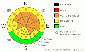
BOTTOM LINE
Danger by aspect and elevation on slopes approaching 35° or steeper.
(click HERE for tomorrow's danger rating)
|
Danger Rose Tutorial
|
There is a CONSIDERABLE (3) danger in the backcountry around Logan, with storm snow and wind slab avalanches probable on upper elevation slopes approaching and steeper than about 35 degrees. Dangerous avalanche conditions could develop, with periods of continued heavy snowfall and increasing northwest winds in the forecast, especially on slopes with significant deposits of new or drifted new snow... Natural avalanches involving the new snow are possible during periods of very heavy snowfall or sustained wind drifting...
Careful snowpack evaluation, cautious route-finding and conservative decision-making are essential for safe backcountry travel today. |
|
|
CURRENT CONDITIONS |

|
The Central Bear River Range picked up another nice shot of fresh powder overnight, temperatures dropped, the winds calmed, and winter has returned to the region... Its a cool 12 degrees at the Campbell Scientific-Logan Peak weather station at 9700', and the wind sensor appears to be rimed. The Tony Grove Snotel reports about 14" of new snow containing 1.2 inches of water. The station reports 72" of total snow with 64% of average water for the date. Continued heavy snowfall and increasing northwest winds are forecast for today. |
|
|
RECENT ACTIVITY |

|
A rider on a powder-surf board triggered a soft wind slab avalanche and was then caught and carried over rocks in steep terrain west of Tony Grove Lake on Saturday. The 12 to 18 inch deep and 50' wide avalanche involved drifted fresh snow deposited in a couple dusty layers by the windy Thursday-Friday storms, and the slab failed on the crusty old snow interface....
Here's an updated local backcountry avalanche list:
|
|
|
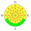
THREAT #1 |

|
| WHERE |
PROBABILITY |
SIZE |
TREND |
|
|
|
|
| |
|
|
Over the next
24 hours.
|
|
|
Storm snow and wind slab avalanches are possible this morning and the danger is likely to rise today with significantly more snow and increasing west winds likely. In some areas today's new storm snow may not bond very well to much warmer underlying snow. Storm snow avalanches may fail on weak layers or density differences within the new snow. Natural avalanches involving the new snow may occur during periods of intense heavy snowfall or with sustained wind drifting... |
|
|
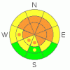
THREAT #2 |

|
| WHERE |
PROBABILITY |
SIZE |
TREND |
|
|
|
|
| |
|
|
Over the next
12 hours.
|
|
|
Watch out for fresh or buried wind slabs near ridge tops, around rock outcroppings or cliffy areas, near sub-ridges and in gullies or scoops. Today's wind slabs will not necessarily be obvious and you should use caution in complex terrain... Even shallow or soft wind slabs or storm snow avalanches could be a problem if you get caught and carried into trees or other terrain traps below.... |
|
|
MOUNTAIN WEATHER |

|
Snow will continue in the mountains today and taper off tonight... 3 to 5 additional inches of accumulation are forecast for today with intensifying northwest winds... Northwest winds will be strong tonight. The National Weather Service continued a Winter Storm Warning for the mountains of Northern Utah through tomorrow morning.... |
|
|
GENERAL ANNOUNCEMENTS |
Send us your avalanche and snow observations. You can also call me at 435-757-7578 or the SLC office at 800-662-4140, or email to uac@utahavalanchecenter.org
Donate to your favorite non-profit – The Friends of the Utah Avalanche Center. The UAC depends on contributions from users like you to support our work.
The information in this advisory is from the U.S. Forest Service, which is solely responsible for its content. This advisory describes general avalanche conditions and local variations always occur.
I will update this forecast Friday morning. We'll go to weekend and intermittent updates in April. Thanks for checking in.... |
|
|
This information does not apply to developed ski areas or highways where avalanche control is normally done. This advisory is from the U.S.D.A. Forest Service, which is solely responsible for its content. This advisory describes general avalanche conditions and local variations always occur. |
|
This advisory provided by the USDA Forest Service, in partnership with:
The Friends of the Utah Avalanche Center, Utah Division of State Parks and Recreation, Utah Division of Emergency Management, Salt Lake County, Salt Lake Unified Fire Authority and the friends of the La Sal Avalanche Center. See our Sponsors Page for a complete list. |
