BOTTOM LINE
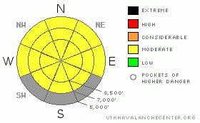
Danger by aspect and elevation on slopes approaching 35° or steeper.
(click HERE for tomorrow's danger rating)
|
Danger Rose Tutorial
|
There is MODERATE (2) danger in the backcountry around Logan, with wind slab and wet avalanches possible today. You might trigger stiff wind slab avalanches 1 to 1.5 feet deep on slopes steeper than about 35 degrees in exposed terrain, especially in and around terrain features like cliff bands, sub ridges, and gullies. Very warm weather conditions will cause a heightened danger of wet avalanches on all steep slopes with saturated surface snow. Watch for signs of wet activity, like snails, roller balls, or wet avalanche activity and leave when the snow in an area becomes soft and wet...
Evaluate the snow and terrain carefully and continue to follow safe travel protocols... |
|
|
CURRENT CONDITIONS |

|
It's already 38 degrees at the Tony Grove Snotel this morning, and the station reports an inch of snow and maybe a little rain overnight. There's currently 63 inches of total snow at the site, containing 62% of average water for the date. The 9700' Campbell Scientific-Logan Peak weather station reports a warmish temperature of 30 degrees this morning, and a strong southwest wind, currently averaging around 30 mph. |
|
|
RECENT ACTIVITY |

|
A powder-board rider triggered a soft wind slab avalanche and was then caught and carried over rocks in steep terrain west of Tony Grove Lake on Saturday. The 12 to 18 inch deep and 50' wide avalanche involved drifted fresh snow deposited in a couple dusty layers by the windy Thursday-Friday storms, and the slab failed on the crusty old snow interface....
Here's an updated local backcountry avalanche list:
|
|
|
THREAT #1 |

|
| WHERE |
PROBABILITY |
SIZE |
TREND |

|
|
|
|
| |
|
|
Over the next
24 hours.
|
|
|
With overnight and continuing strong southwest winds, I'd expect to find stiff wind slabs in upper elevation exposed terrain. Although probably fairly stubborn, you could trigger hard wind slabs on very steep slopes..... In strong winds, wind slabs are likely to form in and around terrain features well off ridge-lines in lee terrain. You need to be wary of areas exposed to winds blowing across and "cross-loading" slopes... Watch for stiff wind slabs around rock outcroppings or cliffy areas, near sub-ridges and in gullies or scoops. Today's wind slabs will be obvious and should be treated with caution in complex terrain... Even shallow or softer wind slabs could be a problem if you get caught and carried into trees or other terrain traps below.... |
|
|
THREAT #2 |

|
| WHERE |
PROBABILITY |
SIZE |
TREND |

|
|
|
|
| |
|
|
Over the next
10 hours.
|
|
|
Expect a heightened avalanche danger today as the snow in many areas did not freeze overnight and temperatures even at upper elevations in the mountains will soar into the upper 40's. Loose wet avalanches will be likely as soon as the surface of the new snow becomes saturated.... Avalanches involving the several inches of new snow could entrain substantial quantities of snow in decent and pile up deeply, especially on longer sustained pitched slopes... In some very steep areas with shallow snow cover, avalanches could gouge into saturated old snow a be fairly large and destructive... |
|
|
MOUNTAIN WEATHER |

|
Snow showers are possible, but its going to get quite warm, and it is windy! An increase in southwest wind speeds is likely, and temperatures will push 50 degrees in the mountains today.... Winds will continue overnight tonight and into tomorrow ahead of a strong Pacific storm that will race southward across the region on Tuesday night... At this point accumulation numbers don't look very high and again most of the energy is going south, but we could pick up several inches of new snow.... (9-17" forecast in our area for the Tue-Wed 36 hour time frame). |
|
|
GENERAL ANNOUNCEMENTS |
We will continue to issue morning avalanche advisories for the Logan area on Mondays, Wednesdays, Fridays and Saturdays through the rest of March. We'll then go to a weekend and intermittent update schedule in April...
Consider purchasing some Beaver Mountain lift tickets here from our good friends at Backcountry.com in partnership with Ski Utah. All proceeds benefit the Friends of the Utah Avalanche Center.
If you want to get this avalanche advisory e-mailed to you daily click HERE.
Send us your avalanche and snow observations. You can also call me at 435-757-7578 or the SLC office at 800-662-4140, or email to uac@utahavalanchecenter.org
Donate to your favorite non-profit – The Friends of the Utah Avalanche Center. The UAC depends on contributions from users like you to support our work.
The information in this advisory is from the U.S. Forest Service, which is solely responsible for its content. This advisory describes general avalanche conditions and local variations always occur.
I will update this forecast Wednesday morning. Thanks for checking in.... |
|
|
This information does not apply to developed ski areas or highways where avalanche control is normally done. This advisory is from the U.S.D.A. Forest Service, which is solely responsible for its content. This advisory describes general avalanche conditions and local variations always occur. |
|
This advisory provided by the USDA Forest Service, in partnership with:
The Friends of the Utah Avalanche Center, Utah Division of State Parks and Recreation, Utah Division of Emergency Management, Salt Lake County, Salt Lake Unified Fire Authority and the friends of the La Sal Avalanche Center. See our Sponsors Page for a complete list. |
