BOTTOM LINE
Danger by aspect and elevation on slopes approaching 35° or steeper.
(click HERE for tomorrow's danger rating)
|
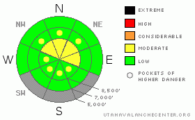
Danger Rose Tutorial
|
There is MODERATE (2) danger at upper elevations in the backcountry. You could trigger wind slab avalanches in exposed terrain, especially near ridge-tops and in and around terrain features like cliff bands, sub ridges, and gullies. You'll find a generally LOW (1) danger and solidly frozen snow under a couple new inches on most slopes at lower and mid elevations...
Use normal caution and continue to follow safe travel protocols... |
|
|
CURRENT CONDITIONS |

|
Yesterday was a bit winter like up high, with high winds and sideways snow falling for a bit. Expect continued cold temperatures and variable surface conditions as well today. The 9700' Campbell Scientific-Logan Peak weather station reports a chilly temperature of 16 degrees this morning, and a north wind, currently averaging a bit less than 10 mph. It's 23 degrees at the Tony Grove Snotel at 6:00am this morning, and the station reports four tenths of an inch of water equivalent in about 4 inches of new snow overnight. There's currently 64 inches of total snow at the site, containing 61% of average water for the date. |
|
|
RECENT ACTIVITY |

|
Locally, skiers triggered a couple shallow and manageable wind slabs in exposed terrain during yesterday's wind... Otherwise no avalanches were reported or observed since last weekend's loose wet activity.
Here's an updated local backcountry avalanche list:
|
|
|
THREAT #1 |

|
| WHERE |
PROBABILITY |
SIZE |
TREND |

|
|
|
|
| |
|
|
Over the next
10 hours.
|
|
|
Wind slabs consisting of yesterday's drifted snow are possible in steep exposed terrain. We noted drifts and some cracking yesterday around a foot deep and deeper in places. Shallow or isolated wind slabs could be a problem if you get caught and carried into trees or other terrain traps below.... |
|
|
THREAT #2 |

|
| WHERE |
PROBABILITY |
SIZE |
TREND |

|
|
|
|
| |
|
|
Over the next
10 hours.
|
|
|
Colder temperatures = less risk of wet avalanches, and the saturated snow on many slopes is now set up like icy concrete... East and west facing slopes at upper elevations sport a thick melt-freeze crust from warmth and strong sun from the past few weeks, and this caps dry winter-like snow and, in some cases, weak sugary layers... The snow is still mostly winter-like at upper elevations on northerly aspects....
More accumulation than forecast will cause the danger of fresh wind slab avalanches to increase and become more widespread... Warming over the weekend will likely cause a rise in wet avalanche danger.... |
|
|
MOUNTAIN WEATHER |

|
Stormy, winter like weather will return to the mountains today with high temperatures expected to reach only about 21 degrees above 8000 feet. Winds will keep it cool as they flow from the Northwest between 6 and 14mph. The National Weather Service is predicting 2-4 inches of accumulation at high elevation, but that might be generous as once again the brunt of storm energy hits Central and Southern Utah. The weekend looks clear and sunny with warmer temps moving in. |
|
|
GENERAL ANNOUNCEMENTS |
Thanks to Paige Pagnucco for help with Today's advisory: We will continue to issue morning avalanche advisories for the Logan area on Mondays, Wednesdays, Fridays and Saturdays through the rest of March. We'll then go to a weekend and intermittent update schedule in April...
Consider purchasing some Beaver Mountain lift tickets here from our good friends at Backcountry.com in partnership with Ski Utah. All proceeds benefit the Friends of the Utah Avalanche Center.
If you want to get this avalanche advisory e-mailed to you daily click HERE.
Send us your avalanche and snow observations. You can also call me at 435-757-7578 or the SLC office at 800-662-4140, or email to uac@utahavalanchecenter.org
Donate to your favorite non-profit – The Friends of the Utah Avalanche Center. The UAC depends on contributions from users like you to support our work.
The information in this advisory is from the U.S. Forest Service, which is solely responsible for its content. This advisory describes general avalanche conditions and local variations always occur.
We will update this forecast Saturday morning. Thanks for checking in.... |
|
|
This information does not apply to developed ski areas or highways where avalanche control is normally done. This advisory is from the U.S.D.A. Forest Service, which is solely responsible for its content. This advisory describes general avalanche conditions and local variations always occur. |
|
This advisory provided by the USDA Forest Service, in partnership with:
The Friends of the Utah Avalanche Center, Utah Division of State Parks and Recreation, Utah Division of Emergency Management, Salt Lake County, Salt Lake Unified Fire Authority and the friends of the La Sal Avalanche Center. See our Sponsors Page for a complete list. |
