BOTTOM LINE
Danger by aspect and elevation on slopes approaching 35° or steeper.
(click HERE for tomorrow's danger rating)
|
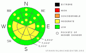
Danger Rose Tutorial
|
The danger will likely rise to MODERATE (2) with today's warm-up. Loose wet avalanches involving a few inches of new snow are likely on southeast through southwest facing slopes with daytime heating... Some of these could entrain large piles of heavy wet snow, especially on long slopes with sustained pitch. Shallow and isolated wind slab avalanches are also possible in steep exposed terrain at upper elevations... Although now rather unlikely, dangerous persistent and deep slab avalanches remain possible in isolated, steep shady terrain...
Use normal caution and continue to follow safe travel protocols... |
|
|
CURRENT CONDITIONS |

|
We found nice shallow powder and smooth dust-on-crust conditions at upper elevations yesterday, but today's warmth is likely to turn the new snow into mush on sunny slopes today. The 9700' Campbell Scientific-Logan Peak weather station reports a fairly chilly temperature of 15 degrees this morning, and an east-southeast wind, currently averaging a bit less than 10 mph....It's 22 degrees up at the Tony Grove Snotel at 5:00 this morning, and the station reports a half inch of water equivalent in about 5 inches of new snow in the last 48 hours. There's currently 62 inches of total snow at the site, containing 61% of average water for the date. |
|
|
RECENT ACTIVITY |

|
Locally, we observed evidence of a few shallow wind slabs and cornice falls from yesterday's wind... Otherwise no avalanches were reported or observed since last weekend's loose wet activity.
Here's an updated local backcountry avalanche list:
|
|
|
THREAT #1 |

|
| WHERE |
PROBABILITY |
SIZE |
TREND |

|
|
|
|
| |
|
|
Over the next
10 hours.
|
|
|
Solar heating will certainly be a factor today...Remember, when the snow gets soft and saturated it's time to leave steep terrain. This is especially true if you notice natural avalanches nearby or start sinking into bottomless mush...
At upper elevations and in areas that received a few inches of fresh snow yesterday, wet loose avalanches entraining saturated new snow on the surface may become likely. These could pick up a fair amount of snow in descent, especially on long steep slopes. |
|
|
THREAT #2 |

|
| WHERE |
PROBABILITY |
SIZE |
TREND |

|
|
|
|
| |
|
|
Over the next
10 hours.
|
|
|
Wind slabs consisting of yesterday's drifted snow are possible in steep exposed terrain. We noted drifts and some cracking yesterday around a foot deep and deeper in places. Shallow or isolated wind slabs could be a problem if you get caught and carried into trees or other terrain traps below....
Persistent and deep slab avalanches are unlikely in most areas, but you might still be able to trigger a dangerous exception in very steep terrain with lingering weak snow structure or persistent weak sugary layers... Use caution and better judgment in steep lightly tracked or untraveled terrain at upper elevations and in areas with shallow or hollow feeling snow... |
|
|
MOUNTAIN WEATHER |

|
A high pressure system will build into the region today, and we'll see much warmer temperatures and lots of spring sunshine in the mountains today. Our next chance for a bit of spring snow will come tomorrow, expect fairly strong southwest winds to develop and some snowfall, mainly in the afternoon... Storminess will continue Thursday night and Friday, but we'll be lucky to see more than a couple inches of accumulation, with around 6 inches possible by Saturday morning. A high pressure system and fair weather will set up for the coming weekend... |
|
|
GENERAL ANNOUNCEMENTS |
I will be issuing morning avalanche advisories for the Logan area on Mondays, Wednesdays, Fridays and Saturdays through March.
Consider purchasing some Beaver Mountain lift tickets here from our good friends at Backcountry.com in partnership with Ski Utah. All proceeds benefit the Friends of the Utah Avalanche Center.
If you want to get this avalanche advisory e-mailed to you daily click HERE.
Send us your avalanche and snow observations. You can also call me at 435-757-7578 or the SLC office at 800-662-4140, or email to uac@utahavalanchecenter.org
Donate to your favorite non-profit – The Friends of the Utah Avalanche Center. The UAC depends on contributions from users like you to support our work.
The information in this advisory is from the U.S. Forest Service, which is solely responsible for its content. This advisory describes general avalanche conditions and local variations always occur.
We will update this forecast Friday morning. Thanks for checking in.... |
|
|
This information does not apply to developed ski areas or highways where avalanche control is normally done. This advisory is from the U.S.D.A. Forest Service, which is solely responsible for its content. This advisory describes general avalanche conditions and local variations always occur. |
|
This advisory provided by the USDA Forest Service, in partnership with:
The Friends of the Utah Avalanche Center, Utah Division of State Parks and Recreation, Utah Division of Emergency Management, Salt Lake County, Salt Lake Unified Fire Authority and the friends of the La Sal Avalanche Center. See our Sponsors Page for a complete list. |
