BOTTOM LINE
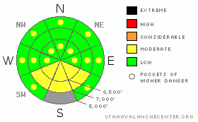
Danger by aspect and elevation on slopes approaching 35° or steeper.
(click HERE for tomorrow's danger rating)
|
Danger Rose Tutorial
|
There's a LOW (1) danger in the backcountry around Logan, and avalanches are generally unlikely in steep terrain. Pockets of MODERATE (2) danger exist at upper elevations, and exceptional triggered persistent slab avalanches are still possible on very steep lightly traveled slopes with buried weak layers. The danger will likely rise to MODERATE (2) on Tuesday, with loose wet avalanches involving a few inches of new snow likely on southeast through southwest facing slopes with daytime heating... Some of these could entrain large piles of heavy wet snow, especially on long slopes with sustained pitch.
Use normal caution and continue to follow safe travel protocols... |
|
|
CURRENT CONDITIONS |

|
Overnight temperatures in the mountains did not drop as far as I would have liked, but appear to have dropped below freezing, at least for a little while at most stations. This will only offer a superficial re-freeze on slopes softened by solar heating over the weekend. The 9700' Campbell Scientific-Logan Peak weather station reports a fairly mild temperature of 23 degrees this morning, and a west-northwest wind, currently averaging a bit more than 15 mph....It's 34 degrees up at the Tony Grove Snotel at 5:00 this morning, and the station reports a recent inch of snow accumulation. There's currently 61 inches of total snow at the site, containing 61% of average water for the date. |
|
|
RECENT ACTIVITY |

|
A handful of wet slab avalanches were reported to the UAC over the weekend. These were mostly from the Provo Area Mountains, but one nice slab pulled out on to the ground on a lower elevation slope above Parley's Canyon on Saturday...
Locally, we observed a few wet loose avalanches in steep terrain on southeast and southwest facing slopes involving a couple inches of new snow with Saturday's warmth.. Most of the slides I saw on Saturday started as point releases on upper elevation rock bands or bigger cliffs and fanned out, engulfing fresh surface snow... Some of these, on longer slopes, picked up fairly substantial piles in descent....
Here's an updated local backcountry avalanche list:
|
|
|
THREAT #1 |

|
| WHERE |
PROBABILITY |
SIZE |
TREND |

|
|
|
|
| |
|
|
Over the next
24 hours.
|
|
|
Persistent and deep slab avalanches are unlikely in most areas, but you might still be able to trigger a dangerous exception in very steep terrain with lingering weak snow structure or persistent weak sugary layers... Use caution and better judgment in steep lightly tracked or untraveled terrain at upper elevations and in areas with shallow or hollow feeling snow... |
|
|
THREAT #2 |

|
| WHERE |
PROBABILITY |
SIZE |
TREND |

|
|
|
|
| |
|
|
Over the next
10 hours.
|
|
|
Indirect solar heating or green-housing could warm the snow enough on steep sheltered slopes for wet avalanches to become possible. Remember, when the snow gets soft and saturated it's time to leave steep terrain. This is especially true if you start sinking into bottomless mush... In areas that receive more fresh snow today, wet loose avalanches entraining saturated new snow on the surface may become probable. These could pick up a fair amount of snow in descent, especially on long steep slopes. |
|
|
MOUNTAIN WEATHER |

|
A cold front from the latest weak Pacific through is slowly approaching the mountains of Northern Utah this morning. We'll likely see an inch or two of accumulation with light snow today, with the heaver precipitation holding off until the afternoon. Expect mountain temperatures in the upper twenties today, with cloud cover, light snow and moderate northwest winds. A high pressure system will build into the region midweek and our next chance for a bit of spring snow will come on around Thursday into Friday as the next series of troughs move through the region.... |
|
|
GENERAL ANNOUNCEMENTS |
I will be issuing morning avalanche advisories for the Logan area on Mondays, Wednesdays, Fridays and Saturdays through March.
Consider purchasing some Beaver Mountain lift tickets here from our good friends at Backcountry.com in partnership with Ski Utah. All proceeds benefit the Friends of the Utah Avalanche Center.
If you want to get this avalanche advisory e-mailed to you daily click HERE.
Send us your avalanche and snow observations. You can also call me at 435-757-7578 or the SLC office at 800-662-4140, or email to uac@utahavalanchecenter.org
Donate to your favorite non-profit – The Friends of the Utah Avalanche Center. The UAC depends on contributions from users like you to support our work.
The information in this advisory is from the U.S. Forest Service, which is solely responsible for its content. This advisory describes general avalanche conditions and local variations always occur.
We will update this forecast Wednesday morning. Thanks for checking in.... |
|
|
This information does not apply to developed ski areas or highways where avalanche control is normally done. This advisory is from the U.S.D.A. Forest Service, which is solely responsible for its content. This advisory describes general avalanche conditions and local variations always occur. |
|
This advisory provided by the USDA Forest Service, in partnership with:
The Friends of the Utah Avalanche Center, Utah Division of State Parks and Recreation, Utah Division of Emergency Management, Salt Lake County, Salt Lake Unified Fire Authority and the friends of the La Sal Avalanche Center. See our Sponsors Page for a complete list. |
