BOTTOM LINE
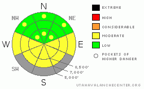
Danger by aspect and elevation on slopes approaching 35° or steeper.
(click HERE for tomorrow's danger rating)
|
Danger Rose Tutorial
|
There's a LOW (1) danger in the backcountry around Logan this morning. Avalanches are generally unlikely in steep terrain, but a Low danger does not mean No danger, and I'm not suggesting you go blindly dropping into just any steep slope.. Pockets of MODERATE (2) danger exist at upper elevations, and exceptional triggered persistent slab avalanches are still possible, especially on very steep, lightly traveled or untraveled slopes with buried weak layers or generally weak shallow snow structure. Also, solar heating will soften the saturated or fresh snow on sunny slopes enough for wet avalanches to become probable, and the danger will rise to MODERATE (2) on steep sunny slopes... The danger of wet avalanches could rise further with heating in the next couple days...
Use normal caution and continue to follow safe travel protocols... |
|
|
CURRENT CONDITIONS |

|
For the second night running, overnight temperatures in the mountains dropped into the lower teens, which has solidified the saturated snow on most slopes into icy concrete. The 9700' Campbell Scientific-Logan Peak weather station reports a very nice and cold temperature of 9 degrees this morning, and a north wind currently averaging less than 10 mph....
A few inches of snow fell overnight in the Bear River Range, with more apparently on the east side of the zone. 6 new inches of fresh powder fell at the Doc Daniels Snotel since yesterday afternoon, while Beaver Mt. reports 2". The Tony Grove Snotel reports 3 inches of accumulation, containing 3/10ths of an inch of water. There's currently 65 inches of total snow at the site, containing 62% of average water for the date. |
|
|
RECENT ACTIVITY |

|
Skiers intentionally triggered a large and dangerous hard slab avalanche with a cornice drop in very steep upper elevation terrain in the Little Cottonwood Canyon Area in the Salt Lake Mountains yesterday...
Locally, no avalanches reported since a few wet avalanches with last week's warmth....
Here's an updated local backcountry avalanche list:
|
|
|
THREAT #1 |

|
| WHERE |
PROBABILITY |
SIZE |
TREND |

|
|
|
|
| |
|
|
Over the next
24 hours.
|
|
|
Persistent and deep slab avalanches are unlikely in most areas, but you might still be able to trigger a dangerous exception in very steep terrain with lingering weak snow structure or persistent weak sugary layers... Use caution and better judgment in steep lightly tracked or untraveled terrain at upper elevations and in areas with shallow or hollow feeling snow... |
|
|
THREAT #2 |

|
| WHERE |
PROBABILITY |
SIZE |
TREND |

|
|
|
|
| |
|
|
Over the next
10 hours.
|
|
|
Cooler overnight temperatures for the last couple nights should keep the wet avalanche problem in check for the most part... However, solar heating could warm the snow enough on a few steep sunny slopes for wet avalanches to become possible. Remember, when the snow gets soft and saturated it's time to leave steep terrain... In areas that received more fresh snow, wet loose avalanches involving the couple inches of new snow on the surface may become possible... On long slopes, these could entrain a fair amount of snow in descent.
The danger of wet avalanches will probably rise with daytime heating in the next couple days... |
|
|
MOUNTAIN WEATHER |

|
A high pressure system will bring fair weather and warming conditions for the weekend. Expect mountain temperatures in the mid to upper twenties today, low twenties tonight, and upper thirties tomorrow.... Our next chance for a bit of spring snow will come on around Monday into Tuesday as the next trough moves through the region on a similar trajectory as yesterday's.... |
|
|
GENERAL ANNOUNCEMENTS |
I will be issuing morning avalanche advisories for the Logan area on Mondays, Wednesdays, Fridays and Saturdays through March.
Consider purchasing some Beaver Mountain lift tickets here from our good friends at Backcountry.com in partnership with Ski Utah. All proceeds benefit the Friends of the Utah Avalanche Center.
If you want to get this avalanche advisory e-mailed to you daily click HERE.
Send us your avalanche and snow observations. You can also call me at 435-757-7578 or the SLC office at 800-662-4140, or email to uac@utahavalanchecenter.org
Donate to your favorite non-profit – The Friends of the Utah Avalanche Center. The UAC depends on contributions from users like you to support our work.
The information in this advisory is from the U.S. Forest Service, which is solely responsible for its content. This advisory describes general avalanche conditions and local variations always occur.
We will update this forecast Monday morning. Thanks for checking in.... |
|
|
This information does not apply to developed ski areas or highways where avalanche control is normally done. This advisory is from the U.S.D.A. Forest Service, which is solely responsible for its content. This advisory describes general avalanche conditions and local variations always occur. |
|
This advisory provided by the USDA Forest Service, in partnership with:
The Friends of the Utah Avalanche Center, Utah Division of State Parks and Recreation, Utah Division of Emergency Management, Salt Lake County, Salt Lake Unified Fire Authority and the friends of the La Sal Avalanche Center. See our Sponsors Page for a complete list. |
