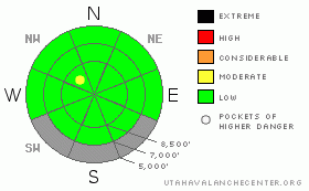
BOTTOM LINE
Danger by aspect and elevation on slopes approaching 35° or steeper.
(click HERE for tomorrow's danger rating)
|
Danger Rose Tutorial
|
There's a LOW (1) danger in the backcountry around Logan. A Low danger does not mean No danger.... I'm not suggesting you go blindly dropping into any steep slope, but avalanches are generally unlikely in steep terrain for the first time in months... Although unlikely, exceptional triggered avalanches are still possible, especially on very steep, lightly or untraveled slopes with weak or shallow snow cover. Warmer temperatures or significantly more snow accumulation than forecast will cause a rise in danger...
Use normal caution and continue to follow safe travel protocols... |
|
|
CURRENT CONDITIONS |

|
Temperatures in the mountains plummeted overnight, which has solidified the saturated snow on most slopes into icy concrete.
The 9700' Campbell Scientific-Logan Peak weather station reports a chilly temperature of 13 degrees this morning, and a north-northwesterly breeze, currently averaging around 12 mph. The Tony Grove Snotel also reports overnight temperatures well below freezing, and there's currently 62 inches of total snow containing 62% of average water for the date. |
|
|
RECENT ACTIVITY |

|
Loose wet avalanches triggered large wet slab avalanches yesterday on east facing slopes off Mt Timpanogos in the Provo Area Mountains.
Locally, we've noticed a few less significant and not unexpected loose wet avalanches resulting from this week's sustained warm weather. Much cooler weather overnight and today should keep avalanche activity at bay....
Here's an updated local backcountry avalanche list:
|
|
|
THREAT #1 |

|
| WHERE |
PROBABILITY |
SIZE |
TREND |

|
|
|
|
| |
|
|
Over the next
24 hours.
|
|
|
Cooler temperatures overnight and today will keep the wet avalanche problem in check... Persistent and deep slab avalanches are unlikely in most areas, but you might still be able to trigger a dangerous exception in very steep terrain with lingering weak snow structure... Use caution in steep lightly or untraveled terrain and in areas with shallow or hollow feeling snow... |
|
|
MOUNTAIN WEATHER |

|
A storm out of the north will slide by to our east today, likely bringing several inches of snow to the Uinta Mountains and more to Colorado and again leaving the Logan Area with the short straw... Expect one to two inches to fall in showery bursts at upper elevations around here and a possibility of thunder snow when the unstable atmosphere heats up today. It will be fairly cold and a few more snow showers are possible tonight, but significant accumulations are unlikely. Expect temperatures to drop into the low teens overnight... A high pressure system will bring fair weather and warming conditions for the weekend, and our next chance for a bit of spring snow will come on around Monday night into Tuesday as the next trough moves into the area.... |
|
|
GENERAL ANNOUNCEMENTS |
I will be issuing morning avalanche advisories for the Logan area on Mondays, Wednesdays, Fridays and Saturdays through March.
Consider purchasing some Beaver Mountain lift tickets here from our good friends at Backcountry.com in partnership with Ski Utah. All proceeds benefit the Friends of the Utah Avalanche Center.
If you want to get this avalanche advisory e-mailed to you daily click HERE.
Send us your avalanche and snow observations. You can also call me at 435-757-7578 or the SLC office at 800-662-4140, or email to uac@utahavalanchecenter.org
Donate to your favorite non-profit – The Friends of the Utah Avalanche Center. The UAC depends on contributions from users like you to support our work.
The information in this advisory is from the U.S. Forest Service, which is solely responsible for its content. This advisory describes general avalanche conditions and local variations always occur.
We will update this forecast tomorrow morning. Thanks for checking in.... |
|
|
This information does not apply to developed ski areas or highways where avalanche control is normally done. This advisory is from the U.S.D.A. Forest Service, which is solely responsible for its content. This advisory describes general avalanche conditions and local variations always occur. |
|
This advisory provided by the USDA Forest Service, in partnership with:
The Friends of the Utah Avalanche Center, Utah Division of State Parks and Recreation, Utah Division of Emergency Management, Salt Lake County, Salt Lake Unified Fire Authority and the friends of the La Sal Avalanche Center. See our Sponsors Page for a complete list. |
