BOTTOM LINE
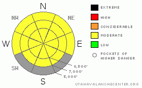
Danger by aspect and elevation on slopes approaching 35° or steeper.
(click HERE for tomorrow's danger rating)
|
Danger Rose Tutorial
|
There's a MODERATE (2) danger in the backcountry around Logan, and triggered avalanches are possible on many steep slopes in the region...Heightened avalanche conditions exist on shady slopes at upper and mid elevations where buried persistent weak layers are still a concern. Some exceptional natural deep or persistent slab avalanches are possible in steep terrain, and warmth-softened slabs in some areas may now be more sensitive to human triggers. Wet avalanches and cornice falls will again become probable today on any steep slope with soft and saturated snow in the heat of midday. Sunny, sheltered slopes will be most suspect, but green-housing could cause wet avalanche problems on mid elevation shady slopes as well....
Evaluate the snow and terrain carefully, follow safe backcountry travel protocols, and continue to make conservative decisions today. |
|
|
CURRENT CONDITIONS |

|
The Campbell Scientific-Logan Peak weather station reports a balmy temperature of 34 degrees this morning, and a northwesterly breeze averaging around 12 mph at the ridge-top at 9700' . The Tony Grove Snotel also reports overnight temperatures above freezing and there's currently 63 inches of total snow containing 64% of average water for the date.
Expect only a superficial radiation re-freeze of the snow surface this morning, and the snow on many slopes will probably soften a bit quicker today than it did yesterday... If you head out early, you might find nice spring corn conditions on some sunny slopes, but you should be getting off them before they get too soft and saturated. You can still find patches of settled powder on upper elevation north facing slopes, but the spring warmth has affected all but the shadiest lines.... |
|
|
RECENT ACTIVITY |

|
We noticed a few natural loose wet avalanches and small cornice falls yesterday on very steep east facing slopes off the south ridge of Mt. Magog... Other natural wet avalanches probably occurred in yesterday's heat, but none were reported to the Utah Avalanche Center.
It's been a week since a skier remote triggered a large and destructive deep slab avalanche while ascending near the Logan Peak-Little Baldy ridge in Upper Logan Dry Canyon last Wednesday. The avalanche, with very hard and solid car-sized blocks, ran violently through trees below and down the full 1200'+ length of it's path.
Here's an updated local backcountry avalanche list:
|
|
|
THREAT #1 |

|
| WHERE |
PROBABILITY |
SIZE |
TREND |

|
|
|
|
| |
|
|
Over the next
48 hours.
|
|
|
Avalanches in some cases might release on deeply buried weak layers creating large and dangerous avalanches. The danger of persistent or deep slab avalanches is higher in un-disturbed or untracked terrain, like in the Mount Naomi and Wellsville Mountain Wildernesses, or in other areas that haven't seen much traffic this season. Last Wednesday's avalanche in Logan Dry Canyon involved wind-loaded snow that overloaded buried weak layers.. In some areas it still might be possible to trigger a dangerous avalanche from a distance or from below.
Warming today could cause an increase in the danger of persistent and deep slab avalanches. The warmth causes both an increased creep rate and softening of slab layers. In some cases, this could lead to exceptional natural avalanches or an increased likelihood of triggering persistent or deep slabs. |
|
|
THREAT #2 |

|
| WHERE |
PROBABILITY |
SIZE |
TREND |

|
|
|
|
| |
|
|
Over the next
10 hours.
|
|
|
Solar heating, fairly calm winds, mild air temperatures, and potential green-housing will all be factors to watch today.... Wet avalanches will become more likely during the heat of midday as the snow on steep sunny slopes softens and becomes saturated... Sunny, sheltered bowl areas can reflect solar energy into themselves and heat up drastically like solar ovens....Avoid travel in such areas and on any steep slope with wet or even moist snow, especially if you start sinking through surface melt-freeze crusts....
Today's wet avalanche problems include:
- Loose wet avalanches- most common problem with heating. These are generally fairly manageable for the triggering party but can be very dangerous for anyone down slope, as they can pick up significant volume in descent.
- Wet or moist slabs- are certainly a concern in areas with existing buried weak layers. Wet slabs can be dangerous and destructive and naturals can be hard to predict since they might not always occur in the heat of midday.
- Cornice Falls- Heating causes the cornices to soften and sag or fail. Large cornice falls may cause an avalanche on slopes below...
- Glide Avalanches- These can occur at any time of day or night. Caused by water flowing under snowpack on rock slab or smooth ground.... Usually associated with glide cracks, natural avalanches are possible in steep terrain. Suspect slopes should be given wide berth.... |
|
|
MOUNTAIN WEATHER |

|
A departing high pressure system will control the weather today, with some high clouds streaming in ahead of the next Pacific weather system... Expect mild conditions in the mountains, with high temperatures today close to 45 degrees at 8500'. Increasing cloud-cover could trap heat in the atmosphere overnight, and there is a small chance of some snowfall after midnight. Snow showers are likely tomorrow afternoon, with some thunder and lightning also possible, but expect little accumulation. Our best shot for new snow comes Thursday night into Friday morning, with 4 to 8 inches of accumulation forecast for upper elevations in the Bear River Range... |
|
|
GENERAL ANNOUNCEMENTS |
I will be issuing morning avalanche advisories for the Logan area on Mondays, Wednesdays, Fridays and Saturdays through March.
Consider purchasing some Beaver Mountain lift tickets here from our good friends at Backcountry.com in partnership with Ski Utah. All proceeds benefit the Friends of the Utah Avalanche Center.
If you want to get this avalanche advisory e-mailed to you daily click HERE.
Send us your avalanche and snow observations. You can also call me at 435-757-7578 or the SLC office at 800-662-4140, or email to uac@utahavalanchecenter.org
Donate to your favorite non-profit – The Friends of the Utah Avalanche Center. The UAC depends on contributions from users like you to support our work.
The information in this advisory is from the U.S. Forest Service, which is solely responsible for its content. This advisory describes general avalanche conditions and local variations always occur.
I will update this forecast Friday morning. Thanks for checking in.... |
|
|
This information does not apply to developed ski areas or highways where avalanche control is normally done. This advisory is from the U.S.D.A. Forest Service, which is solely responsible for its content. This advisory describes general avalanche conditions and local variations always occur. |
|
This advisory provided by the USDA Forest Service, in partnership with:
The Friends of the Utah Avalanche Center, Utah Division of State Parks and Recreation, Utah Division of Emergency Management, Salt Lake County, Salt Lake Unified Fire Authority and the friends of the La Sal Avalanche Center. See our Sponsors Page for a complete list. |
