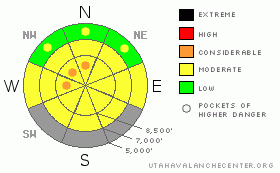
BOTTOM LINE
Danger by aspect and elevation on slopes approaching 35° or steeper.
(click HERE for tomorrow's danger rating)
|
Danger Rose Tutorial
|
There's a MODERATE (2) danger in the backcountry around Logan, and triggered avalanches are possible on many slopes in the region...Heightened avalanche conditions exist on shady slopes at upper and mid elevations where buried persistent weak layers are still a concern, and as solar warming heats the snow on steep slopes, the danger will likely become more widespread... Pockets with a CONSIDERABLE (3) danger persist in upper elevation drifted terrain, especially in areas that haven't seen much or any recent traffic. Wet avalanches will become possible on any steep slope with soft and saturated snow as daytime temperatures climb. Sunny, sheltered slopes will be most suspect.
Make conservative decisions in the backcountry today, and evaluate the snow and terrain carefully... |
|
|
CURRENT CONDITIONS |

|
The Campbell Scientific-Logan Peak weather station reports steady 15 mph east winds overnight and continuing this morning. Its already a balmy 23 degrees at the communications tower on the 9700' summit. The Tony Grove Snotel reports a couple inches of snow and 3/10ths of an inch of water accumulation in the last 48 hrs. There's currently 67 inches of total snow containing 65% of average water for the date.
Most reports from local observers are of stable and tracked-up conditions in the backcountry, but I'm still leery of big steep slopes, and there are many places where I still won't venture... |
|
|
RECENT ACTIVITY |

|
No avalanches were reported from the Logan Area despite a fairly busy backcountry over the weekend...
A skier remote triggered a large and destructive deep slab avalanche while ascending near the Logan Peak-Little Baldy ridge in Upper Logan Dry Canyon on Wednesday. The avalanche, with very hard and solid car-sized blocks, ran violently through trees below and down the full 1200'+ length of it's path.
Here's an updated local backcountry avalanche list:
|
|
|
THREAT #1 |

|
| WHERE |
PROBABILITY |
SIZE |
TREND |
|
|
|
|
| |
|
|
Over the next
48 hours.
|
|
|
Avalanches in some cases might release on deeply buried weak layers creating large and dangerous avalanches. The danger of persistent or deep slab avalanches is higher in un-disturbed or untracked terrain, like in the Mount Naomi and Wellsville Mountain Wildernesses, or in other areas that haven't seen much traffic this season. Wednesday's avalanche in Logan Dry Canyon involved wind-loaded snow that overloaded buried weak layers.. In some areas you still might might trigger a dangerous avalanche from a distance or from below.
Drastic warming in the next couple days could cause an increase in the danger of persistent and deep slab avalanches. The warmth causes both an increased creep rate and softening of slab layers. In some cases, this could lead to exceptional spontaneous natural avalanches or an increased likelihood of triggering persistent or deep slabs. |
|
|
THREAT #2 |

|
| WHERE |
PROBABILITY |
SIZE |
TREND |

|
|
|
|
| |
|
|
Over the next
10 hours.
|
|
|
Solar heating, fairly calm winds, and mild air temperatures will be factors to watch today.... Wet avalanches will become more likely during the heat of midday as the snow on steep sunny slopes softens and becomes saturated... Sunny, sheltered bowl areas can reflect solar energy into themselves and heat up drastically like solar ovens....Avoid travel in such areas and on any steep slope with wet or even moist snow, especially if you start sinking through surface melt-freeze crusts.... |
|
|
THREAT #3 |

|
| WHERE |
PROBABILITY |
SIZE |
TREND |
|
|
|
|
| |
|
|
Over the next
24 hours.
|
|
|
East winds overnight and this weekend undoubtedly found some snow to drift and likely built stiff slabs on lee slopes and in terrain dictated deposition areas like in gullies, around rock outcroppings, and on the lee sides of sub-ridges… A few triggered wind slabs have been reported from areas well off ridge-lines in the Central Wasatch... |
|
|
MOUNTAIN WEATHER |

|
A high pressure system will control the weather for the next few days... Expect mild conditions in the mountains, with high temperatures today close to 40 degrees at 8500' and even warmer daytime high temperatures expected Tuesday and Wednesday. We're looking at fairly light east winds today, shifting around from the north-northwest later... Some high clouds are expected to develop over the north, which will likely only aid in the warming process. The next Pacific storm will break down the ridge of high pressure mid-week, with frontal passage and a chance for snow showers on Thursday night. |
|
|
GENERAL ANNOUNCEMENTS |
I will be issuing morning avalanche advisories for the Logan area on Mondays, Wednesdays, Fridays and Saturdays.
Consider purchasing some Beaver Mountain lift tickets here from our good friends at Backcountry.com in partnership with Ski Utah. All proceeds benefit the Friends of the Utah Avalanche Center.
If you want to get this avalanche advisory e-mailed to you daily click HERE.
Send us your avalanche and snow observations. You can also call me at 435-757-7578 or the SLC office at 800-662-4140, or email to uac@utahavalanchecenter.org
Donate to your favorite non-profit – The Friends of the Utah Avalanche Center. The UAC depends on contributions from users like you to support our work.
The information in this advisory is from the U.S. Forest Service, which is solely responsible for its content. This advisory describes general avalanche conditions and local variations always occur.
I will update this forecast Wednesday morning. Thanks for checking in.... |
|
|
This information does not apply to developed ski areas or highways where avalanche control is normally done. This advisory is from the U.S.D.A. Forest Service, which is solely responsible for its content. This advisory describes general avalanche conditions and local variations always occur. |
|
This advisory provided by the USDA Forest Service, in partnership with:
The Friends of the Utah Avalanche Center, Utah Division of State Parks and Recreation, Utah Division of Emergency Management, Salt Lake County, Salt Lake Unified Fire Authority and the friends of the La Sal Avalanche Center. See our Sponsors Page for a complete list. |
