BOTTOM LINE
Danger by aspect and elevation on slopes approaching 35° or steeper.
(click HERE for tomorrow's danger rating)
|
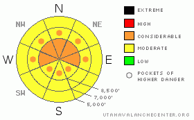
Danger Rose Tutorial
|
The danger in the backcountry will rise with wind and snow today... A CONSIDERABLE (3) danger and dangerous avalanche conditions will likely develop today at upper and mid elevations, as new and drifted snow is deposited on steep slopes and in avalanche starting zones....Dangerous triggered avalanches are already probable this morning on some steep upper and mid elevation slopes, particularly in lightly traveled exposed terrain and on slopes with significant recent deposits of drifted snow.
Make conservative decisions in the backcountry today, and evaluate the snow and terrain carefully... |
|
|
CURRENT CONDITIONS |

|
South winds intensified overnight and are still cranking out close to 30 mph hourly averages at the Campbell Scientific Logan Peak weather station this morning. Its already a balmy 23 degrees at 9700'. The Tony Grove Snotel reports a couple inches of snow overnight. There's currently 67 inches of total snow containing 65% of average water for the date. The National Weather Service has issued a Winter Weather Advisory for our area for today... |
|
|
RECENT ACTIVITY |

|
A skier remote triggered a large and destructive deep slab avalanche while ascending near the Logan Peak-Little Baldy ridge in Upper Logan Dry Canyon on Wednesday. The avalanche, reportedly with car-sized blocks, ran through trees below and sympathetic released other pockets running on the February surface hoar layer. The avalanche ran to the bottom of the path, stopping in the flats above Little Mountain.....
Here's an updated local backcountry avalanche list:
|
|
|
THREAT #1 |

|
| WHERE |
PROBABILITY |
SIZE |
TREND |

|
|
|
|
| |
|
|
Over the next
24 hours.
|
|
|
The strong south winds overnight and this morning undoubtedly found some snow to drift and likely built stout slabs on lee slopes and in terrain dictated deposition areas like in gullies, around rock outcroppings, and on the lee sides of sub-ridges…. Strong winds will continue to drift fresh snow as it falls today… Wind slab and storm snow avalanches will become probable on slopes that receive significant accumulations..
|
|
|
THREAT #2 |

|
| WHERE |
PROBABILITY |
SIZE |
TREND |

|
|
|
|
| |
|
|
Over the next
10 hours.
|
|
|
Drifted snow will overload slopes with persistent buried weak layers today, and the new load will increase the danger of dangerous avalanches stepping down into much harder old snow. Avalanches in some cases might release on deeply buried weak layers creating large and dangerous avalanches. The danger of persistent or deep slab avalanches is higher in un-disturbed or untracked terrain, like in the Mount Naomi and Wellsville Mountain Wildernesses, or in other areas that haven't seen much traffic this season. Wednesday's avalanche in Logan Dry involved wind-loaded snow that overloaded buried weak layers..
In some areas you still might might trigger a dangerous avalanche from a distance or from below. |
|
|
THREAT #3 |

|
| WHERE |
PROBABILITY |
SIZE |
TREND |

|
|
|
|
| |
|
|
Over the next
8 hours.
|
|
|
Cooler temperatures and cloud cover will likely keep a lid on most wet activity. But, rain may fall at lower elevations before the front passes through today, and on some very steep slopes the snow could become saturated and wet and avalanches will become possible. |
|
|
MOUNTAIN WEATHER |

|
We should see rather stormy conditions in the mountains with fairly strong winds and snowfall today. Upper elevation terrain in the Bear River Range could pick up around 6 inches today and a few more tonight, but once again it looks as though most of the storm energy will be to our south... Expect showery, breaking conditions tomorrow and a high pressure system and fair weather will return for the early part of next week.... |
|
|
GENERAL ANNOUNCEMENTS |
I will be issuing morning avalanche advisories for the Logan area on Mondays, Wednesdays, Fridays and Saturdays.
Consider purchasing some Beaver Mountain lift tickets here from our good friends at Backcountry.com in partnership with Ski Utah. All proceeds benefit the Friends of the Utah Avalanche Center.
If you want to get this avalanche advisory e-mailed to you daily click HERE.
Send us your avalanche and snow observations. You can also call me at 435-757-7578 or the SLC office at 800-662-4140, or email to uac@utahavalanchecenter.org
Donate to your favorite non-profit – The Friends of the Utah Avalanche Center. The UAC depends on contributions from users like you to support our work.
The information in this advisory is from the U.S. Forest Service, which is solely responsible for its content. This advisory describes general avalanche conditions and local variations always occur.
I will update this forecast Monday morning. Thanks for checking in.... |
|
|
This information does not apply to developed ski areas or highways where avalanche control is normally done. This advisory is from the U.S.D.A. Forest Service, which is solely responsible for its content. This advisory describes general avalanche conditions and local variations always occur. |
|
This advisory provided by the USDA Forest Service, in partnership with:
The Friends of the Utah Avalanche Center, Utah Division of State Parks and Recreation, Utah Division of Emergency Management, Salt Lake County, Salt Lake Unified Fire Authority and the friends of the La Sal Avalanche Center. See our Sponsors Page for a complete list. |
