BOTTOM LINE
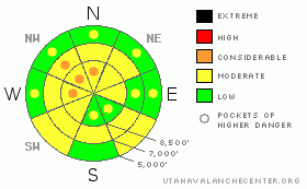
Danger by aspect and elevation on slopes approaching 35° or steeper.
(click HERE for tomorrow's danger rating)
|
Danger Rose Tutorial
|
There is a MODERATE (2) danger and you could trigger avalanches in the backcountry around Logan today. Heightened avalanche conditions exist, and persistent buried weak layers are still a threat, in steep shady upper and mid elevation terrain. I've included pockets with a CONSIDERABLE (3) danger, since dangerous avalanche conditions persist in some areas, particularly on lightly traveled slopes with significant recent deposits of drifted snow. Dangerous triggered avalanches are likely on some steep slopes, particularly in the Southern Bear River Range, in the Wellsville Mountain and Mount Naomi Wildernesses, and on many of the other big northwest facing slopes in the region....Cool overnight temperatures will keep a lid on the danger of wet avalanches today, but avalanches may again be possible midday on very steep lower and mid elevation slopes with saturated snow, especially in sunny sheltered areas.
Use safe travel protocols and evaluate the snow and terrain carefully... |
|
|
CURRENT CONDITIONS |

|
The Tony Grove Snotel reports 2/10ths of an inch of water accumulation in the last 24 hrs. There's 68 inches of total snow containing 65% of average water for the date. It's already 20 degrees and there's a moderate north-northwest wind up at the 9700' CSI weather station on Logan Peak.. |
|
|
RECENT ACTIVITY |

|
A skier remote triggered a large and destructive deep slab avalanche while ascending near the Logan Peak-Little Baldy ridge in Upper Logan Dry Canyon on Wednesday. The avalanche, reportedly with car-sized blocks, ran through trees below and sympathetic released other pockets running on the February surface hoar layer. The avalanche ran to the bottom of the path, stopping in the flats above Little Mountain.....
Here's an updated local backcountry avalanche list:
|
|
|
THREAT #1 |

|
| WHERE |
PROBABILITY |
SIZE |
TREND |

|
|
|
|
| |
|
|
Over the next
24 hours.
|
|
|
The February 10th surface hoar layer is still reactive in some areas. While many areas in the area are mostly stable, some ain't. The danger of persistent slab avalanches is higher in un-disturbed or untracked terrain, like in the Mount Naomi and Wellsville Mountain Wildernesses, or in other areas that haven't seen much traffic this season. Avalanches in some cases might release on deeply buried weak layers creating large and dangerous avalanches. Deep slab avalanches are most likely in exposed terrain where prevailing west winds scoured windward slopes keeping them shallow and weak previously, and then the moderate southeast winds last weekend deposited loads of snow into ridgetop starting zones... Yesterday's avalanche in Logan Dry involved wind-loaded snow that overloaded buried weak layers..
In some areas you still might might trigger a dangerous avalanche from a distance or from below. |
|
|
THREAT #2 |

|
| WHERE |
PROBABILITY |
SIZE |
TREND |

|
|
|
|
| |
|
|
Over the next
10 hours.
|
|
|
Thankfully, overnight temperatures dropped well below freezing again, and this will likely keep a lid on most wet activity. But, on some very steep lower elevation slopes and in sunny, sheltered, solar oven-like terrain, the snow could get softened but midday heating and wet avalanches will become possible. The danger of wet avalanches in the region will rise and become more widespread as temperatures rise at mid elevations. Calm winds won't help matters much, nor will they when they pick up to light this afternoon and bring in even warmer temperatures in a southerly flow. |
|
|
MOUNTAIN WEATHER |

|
Should be nice and sunny and warmer in the mountains today, with light winds shifting around from the southwest this afternoon... Clouds will thicken overnight and there's a chance of some snowfall... Snow is likely tomorrow with about three inches of accumulation possible, but again most of the energy from the storm appears to be heading south...Another 3 or 4 inches may fall on Saturday night, becoming showery by Sunday morning... High pressure and fair weather will return for the early part of next week.... |
|
|
GENERAL ANNOUNCEMENTS |
I will be issuing morning avalanche advisories for the Logan area on Mondays, Wednesdays, Fridays and Saturdays.
Consider purchasing some Beaver Mountain lift tickets here from our good friends at Backcountry.com in partnership with Ski Utah. All proceeds benefit the Friends of the Utah Avalanche Center.
If you want to get this avalanche advisory e-mailed to you daily click HERE.
Send us your avalanche and snow observations. You can also call me at 435-757-7578 or the SLC office at 800-662-4140, or email to uac@utahavalanchecenter.org
Donate to your favorite non-profit – The Friends of the Utah Avalanche Center. The UAC depends on contributions from users like you to support our work.
The information in this advisory is from the U.S. Forest Service, which is solely responsible for its content. This advisory describes general avalanche conditions and local variations always occur.
I will update this forecast tomorrow morning. Thanks for checking in.... |
|
|
This information does not apply to developed ski areas or highways where avalanche control is normally done. This advisory is from the U.S.D.A. Forest Service, which is solely responsible for its content. This advisory describes general avalanche conditions and local variations always occur. |
|
This advisory provided by the USDA Forest Service, in partnership with:
The Friends of the Utah Avalanche Center, Utah Division of State Parks and Recreation, Utah Division of Emergency Management, Salt Lake County, Salt Lake Unified Fire Authority and the friends of the La Sal Avalanche Center. See our Sponsors Page for a complete list. |
