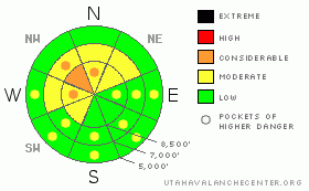
BOTTOM LINE
Danger by aspect and elevation on slopes approaching 35° or steeper.
(click HERE for tomorrow's danger rating)
|
Danger Rose Tutorial
|
There is a MODERATE (2) danger and avalanches are possible in the backcountry around Logan today. Heightened avalanche conditions persist in steep shady mid elevation terrain, where a very persistent buried weak layer is still a threat, and triggered avalanches are possible on slopes approaching or steeper than about 35 degrees...There may be areas where pockets with a CONSIDERABLE (3) danger persist, mainly on steep upper elevation northwest facing slopes with recently wind deposited snow. Cooler temperatures will moderate the danger of wet avalanches today, but avalanches may again be possible midday on very steep lower and mid elevation slopes with saturated snow, especially in sunny sheltered areas.
Use safe travel protocols and evaluate the snow and terrain carefully... |
|
|
CURRENT CONDITIONS |

|
The Tony Grove Snotel reports about 1 inch of new snow from Tuesday evening, with 1/10ths of an inch of water accumulation in the last 24 hrs. There's 68 inches of total snow containing 66% of average water for the date. It's a cool 8 degrees and there's a moderate north-northwest wind up at the 9700' CSI weather station on Logan Peak..
Warm temperatures in the last week have done a number on lower elevation snow cover, burning out sunny slopes and melting out patches of snow around rocks and creek beds... With such a low snow year we have to be really careful not to ride over melted-out patches of fragile ground. In short, we need to make an effort not to cause resource damage by ripping up the landscape. Also, backcountry observers have reported numerous cases recently where snowmobile tracks cross into areas that are closed to motor vehicles, and even some in Wilderness Areas ... We need to know and respect closures in the region. Not only might you get fined, but the acts of a few riders may force some areas to get shut down early, and we may even risk forever loosing more acres to riding..... |
|
|
RECENT ACTIVITY |

|
A skier remote triggered a large and destructive deep slab avalanche in Upper Logan Dry Canyon yesterday. The avalanche, reportedly with car-sized blocks, ran through trees below and sympathetic released other slides running on the February surface hoar layer. One of these ran full path to the flats above Little Mountain.....
Here's an updated local backcountry avalanche list:
|
|
|
THREAT #1 |

|
| WHERE |
PROBABILITY |
SIZE |
TREND |
|
|
|
|
| |
|
|
Over the next
24 hours.
|
|
|
The February 10th surface hoar layer is still reactive in some areas. While many areas in the area are mostly stable, some ain't. We found energetic, clean, and fully propagating failures under a 18" one-finger-hard slab in north facing mid-elevation terrain in the Wellsville Mountain Wilderness on Monday. Also we've still been triggering and continue to receive reports of audible collapses in shady or drifted terrain... The danger of persistent slab avalanches is higher in un-disturbed or untracked terrain, like in the Mount Naomi and Wellsville Mountain Wildernesses, or in other areas that haven't seen much traffic in recent weeks. Avalanches in some cases might step down to deeply buried weak layers creating large and dangerous avalanches.
In some areas you still might might trigger a dangerous avalanche from a distance or from below. |
|
|
THREAT #2 |

|
| WHERE |
PROBABILITY |
SIZE |
TREND |
|
|
|
|
| |
|
|
Over the next
32 hours.
|
|
|
SE winds over the weekend loaded ridge-top deposition areas in exposed terrain, particularly in the Southern Bear River Range and on big northwest facing slopes in the region....
Yesterday's avalanche in Logan Dry involved wind-loaded snow that overloaded buried weak layers.. |
|
|
THREAT #3 |
|
|
| WHERE |
PROBABILITY |
SIZE |
TREND |

|
|
|
|
| |
|
|
Over the next
32 hours.
|
|
|
Thankfully overnight temperatures dropped well below freezing, and we're hoping for cooler overall air temperatures again today. This will likely keep a lid on wet activity, but on some very steep lower elevation slopes and in sunny, solar oven-like terrain, wet avalanches may be possible. The danger of wet avalanches in the region will surely rise and become more widespread again with rising temperatures on Friday... |
|
|
GENERAL ANNOUNCEMENTS |
I will be issuing morning avalanche advisories for the Logan area on Mondays, Wednesdays, Fridays and Saturdays.
Consider purchasing some Beaver Mountain lift tickets here from our good friends at Backcountry.com in partnership with Ski Utah. All proceeds benefit the Friends of the Utah Avalanche Center.
If you want to get this avalanche advisory e-mailed to you daily click HERE.
Send us your avalanche and snow observations. You can also call me at 435-757-7578 or the SLC office at 800-662-4140, or email to uac@utahavalanchecenter.org
Donate to your favorite non-profit – The Friends of the Utah Avalanche Center. The UAC depends on contributions from users like you to support our work.
The information in this advisory is from the U.S. Forest Service, which is solely responsible for its content. This advisory describes general avalanche conditions and local variations always occur.
I will update this forecast Friday morning. Thanks for checking in.... |
|
|
This information does not apply to developed ski areas or highways where avalanche control is normally done. This advisory is from the U.S.D.A. Forest Service, which is solely responsible for its content. This advisory describes general avalanche conditions and local variations always occur. |
|
This advisory provided by the USDA Forest Service, in partnership with:
The Friends of the Utah Avalanche Center, Utah Division of State Parks and Recreation, Utah Division of Emergency Management, Salt Lake County, Salt Lake Unified Fire Authority and the friends of the La Sal Avalanche Center. See our Sponsors Page for a complete list. |
