BOTTOM LINE
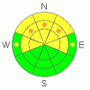
Danger by aspect and elevation on slopes approaching 35° or steeper.
(click HERE for tomorrow's danger rating)
|

Danger Rose Tutorial
|
There is a MODERATE (2) danger and avalanches are possible in the backcountry around Logan today. Heightened avalanche conditions persist in steep shady mid elevation terrain, where a very persistent buried weak layer is still a threat, and triggered avalanches are possible on slopes approaching or steeper than about 35 degrees.. Wet avalanches may again become possible with daytime heating, mainly on very steep lower elevation slopes with shallow soft and saturated snow... Shallow wind slabs in steep exposed terrain could be a problem, especially on slopes with trees or other terrain traps below.
Use safe travel protocols and evaluate the snow and terrain carefully... |
|
|
CURRENT CONDITIONS |

|
Beaver Mountain picked up a couple inches, but the Tony Grove Snotel reports only about 1 inch of new snow from the storm, with 1/10ths of an inch of water accumulation in the last 24 hrs. There's 71 inches of total snow containing 68% of average water for the date. It's 19 degrees and there's a light and shifting wind up at the 9700' CSI weather station on Logan Peak.. |
|
|
RECENT ACTIVITY |

|
Numerous natural loose wet avalanches occurred in the region in the last week, with lower and mid elevation slopes most active.. Friday afternoon, a wet avalanche crossed both lanes and closed down highway 89 in the Dugway section of Logan Canyon, the situation became dangerous when traffic stopped right at the avalanche and numerous people came up to the debris blocking the road. Luckily the bystanders were able to get out of the way, when a second wet avalanche swept off the steep slope above the road, and like tons of melted hot wax, trapped three vehicles and pushed a van into a car....
Also Friday, a skier triggered a good sized slab avalanche in Logan Dry Canyon on the west side of Logan Peak. He was able to self arrest on the bed surface as the 14" deep and around 100' wide avalanche somewhat "slowly" ran around him. The avalanche sympathetic triggered another slightly deeper slide below. Both avalanches failed on an extremely persistent weak surface hoar (frost) layer that was buried on February 10th.
Here's an updated local backcountry avalanche list:
|
|
|
THREAT #1 |

|
| WHERE |
PROBABILITY |
SIZE |
TREND |
|
|
|
|
| |
|
|
Over the next
24 hours.
|
|
|
The February 10th surface hoar layer is still reactive in some areas. While many areas in the area are mostly stable, some ain't. On Saturday afternoon we triggered a handful of collapses in mid elevation north facing terrain, and sure enough there was the surface hoar under only around a foot of snow accumulated over the last three weeks. Quick tests revealed full propagation tendencies, and in some cases quite sensitive.
The danger of persistent slab avalanches is higher in un-disturbed or untracked terrain, like in the Mount Naomi and Wellsville Mountain Wildernesses, or in other areas that haven't seen much traffic in recent weeks. In some areas you still might might trigger a dangerous avalanche from a distance or from below. |
|
|
THREAT #2 |

|
| WHERE |
PROBABILITY |
SIZE |
TREND |

|
|
|
|
| |
|
|
Over the next
8 hours.
|
|
|
Numerous wet avalanches occurred at lower elevations in the area in the last week. With solar heating and greenhousing likely to raise temperatures again today, expect the danger wet avalanches to rise accordingly. Triggered wet avalanches are possible again today on steep slopes lower elevation slopes with soft saturated snow... |
|
|
THREAT #3 |

|
| WHERE |
PROBABILITY |
SIZE |
TREND |

|
|
|
|
| |
|
|
Over the next
24 hours.
|
|
|
You'll find mostly shallow wind slabs in exposed terrain and in and around terrain features where drifts are likely to form.... Soft and stiffer wind slabs should be mostly manageable, but keep your situation in mind and avoid steep drifted slopes with trees or other terrain traps below you. |
|
|
MOUNTAIN WEATHER |

|
A high pressure system will be over the area today, before the next splitting storm sends most of its diminishing energy to our south again tomorrow... Expect moderate westerly winds and temperatures around freezing today in the mountains with clouds and snow showers likely. We could pick up 2 to 4 inches in the mountains tomorrow... |
|
|
GENERAL ANNOUNCEMENTS |
I will be issuing morning avalanche advisories for the Logan area on Mondays, Wednesdays, Fridays and Saturdays.
Consider purchasing some Beaver Mountain lift tickets here from our good friends at Backcountry.com in partnership with Ski Utah. All proceeds benefit the Friends of the Utah Avalanche Center.
If you want to get this avalanche advisory e-mailed to you daily click HERE.
Send us your avalanche and snow observations. You can also call me at 435-757-7578 or the SLC office at 800-662-4140, or email to uac@utahavalanchecenter.org
Donate to your favorite non-profit – The Friends of the Utah Avalanche Center. The UAC depends on contributions from users like you to support our work.
The information in this advisory is from the U.S. Forest Service, which is solely responsible for its content. This advisory describes general avalanche conditions and local variations always occur.
I will update this forecast Wednesday morning. Thanks for checking in.... |
|
|
This information does not apply to developed ski areas or highways where avalanche control is normally done. This advisory is from the U.S.D.A. Forest Service, which is solely responsible for its content. This advisory describes general avalanche conditions and local variations always occur. |
|
This advisory provided by the USDA Forest Service, in partnership with:
The Friends of the Utah Avalanche Center, Utah Division of State Parks and Recreation, Utah Division of Emergency Management, Salt Lake County, Salt Lake Unified Fire Authority and the friends of the La Sal Avalanche Center. See our Sponsors Page for a complete list. |
