BOTTOM LINE
Danger by aspect and elevation on slopes approaching 35° or steeper.
(click HERE for tomorrow's danger rating)
|
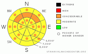
Danger Rose Tutorial
|
The danger of wet avalanches will rise to CONSIDERABLE (3) in the backcountry, with solar heating and greenhousing warming the already saturated snow on many steep slopes today. Triggered wet avalanches will become likely and some naturals can be expected again with daytime heating. Dangerous avalanche conditions also persist in steep shady mid elevation terrain, where a very persistent weak layer buried in early February is still a threat, and triggered avalanches remain probable on slopes steeper than about 30 degrees.. Some avalanches might be triggered from a distance, or worse, from below...
Careful snowpack evaluation, cautious route-finding and conservative decision-making are essential for safe backcountry travel. |
|
|
CURRENT CONDITIONS |

|
The Bear River Range only picked up a couple inches from Thursday night's storm, with up to about 6 observed in the southern part of the range and in the Wellsvilles.. We found nice conditions in shady terrain, where the underlying snow was still somewhat soft.
Hard to believe, but the Tony Grove Snotel reports only about 2 inches of new snow from the storm, with 2/10ths of an inch of water accumulation in the last 48 hrs. There's 71 inches of total snow containing 68% of average water for the date. It's 17 degrees and there's an increasing moderate southeast wind up at the 9700' CSI weather station on Logan Peak, currently recording an average wind speed of around 20 mph... |
|
|
RECENT ACTIVITY |

|
Numerous natural loose wet avalanches occurred in the region in the last couple days, with lower and mid elevation slopes most active.. Avalanches this week descended into low elevation terrain not normally thought of as dangerous, like Lower Green Canyon and the Logan River Trail. Friday afternoon, a wet avalanche crossed both lanes and closed down highway 89 in the Dugway section of Logan Canyon for a few hours. The daytime natural avalanche dropped tons of heavy wet debris on the highway from a mostly west facing slope at around 6300' in elevation. Also Friday, a skier triggered a good sized slab avalanche in Logan Dry Canyon on the west side of Logan Peak. He was able to self arrest on the bed surface as the 14" deep and around 100' wide avalanche somewhat "slowly" ran around him. The avalanche sympathetic triggered another slightly deeper slide below. Both avalanches failed on an extremely persistent weak surface hoar (frost) layer that was buried on February 10th.
Here's an updated local backcountry avalanche list:
|
|
|
THREAT #1 |

|
| WHERE |
PROBABILITY |
SIZE |
TREND |

|
|
|
|
| |
|
|
Over the next
10 hours.
|
|
|
Warm daytime temperatures and poor overnight refreezes have caused the snow on many low and mid elevation slopes to become saturated and slushy... Numerous wet avalanches occurred in the area in the last few days, with a large wet slab release in Logan Canyon yesterday afternoon introducing a whole new avalanche problem into the mix...
With solar heating and greenhousing likely to raise temperatures drastically today, expect the danger wet avalanches to rise accordingly. Triggered wet avalanches will be likely and some naturals can be expected again today on steep slopes with warming saturated snow... |
|
|
THREAT #2 |

|
| WHERE |
PROBABILITY |
SIZE |
TREND |

|
|
|
|
| |
|
|
Over the next
24 hours.
|
|
|
The February 10th surface hoar layer is gradually strengthening and avalanches are getting harder to find and more difficult to trigger. Persistent slab avalanches releasing on this layer now might not be as manageable or forgiving as they were previously. The danger of this type of avalanche is higher in un-disturbed or untracked terrain, like in the Mount Naomi and Wellsville Mountain Wildernesses. In some areas you still might might trigger a dangerous avalanche from a distance or from below.
Dangerous deep slab avalanches are still possible on isolated steep slopes plagued by weak faceted snow in the basal layers of the snowpack. Although triggering one of these monsters is certainly becoming more unlikely, you're most likely to initiate a deep slab avalanche from a shallow part of the slab.. Be aware of and avoid slopes with shallow overall snow cover, especially where the snow near the ground is weak. |
|
|
MOUNTAIN WEATHER |

|
Should be a nice and warm day in the mountains today under a short-lived ridge of high pressure. Expect mountain temperatures to surmount freezing, with a high of about 35 degrees expected at 9000', with lots of sunshine and some clouds building in this afternoon to help trap the heat... Clouds will blow in tonight ahead of a Pacific storm which is heading well to our south but might bring a snowflake or two for Sunday. Periods of snowfall are expected to continue well into next week, but accumulations in our area will likely be light at best..... |
|
|
GENERAL ANNOUNCEMENTS |
I will be issuing morning avalanche advisories for the Logan area on Mondays, Wednesdays, Fridays and Saturdays.
Consider purchasing some Beaver Mountain lift tickets here from our good friends at Backcountry.com in partnership with Ski Utah. All proceeds benefit the Friends of the Utah Avalanche Center.
If you want to get this avalanche advisory e-mailed to you daily click HERE.
Send us your avalanche and snow observations. You can also call me at 435-757-7578 or the SLC office at 800-662-4140, or email to uac@utahavalanchecenter.org
Donate to your favorite non-profit – The Friends of the Utah Avalanche Center. The UAC depends on contributions from users like you to support our work.
The information in this advisory is from the U.S. Forest Service, which is solely responsible for its content. This advisory describes general avalanche conditions and local variations always occur.
I will update this forecast Monday morning. Thanks for checking in.... |
|
|
This information does not apply to developed ski areas or highways where avalanche control is normally done. This advisory is from the U.S.D.A. Forest Service, which is solely responsible for its content. This advisory describes general avalanche conditions and local variations always occur. |
|
This advisory provided by the USDA Forest Service, in partnership with:
The Friends of the Utah Avalanche Center, Utah Division of State Parks and Recreation, Utah Division of Emergency Management, Salt Lake County, Salt Lake Unified Fire Authority and the friends of the La Sal Avalanche Center. See our Sponsors Page for a complete list. |
