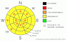
BOTTOM LINE
Danger by aspect and elevation on slopes approaching 35° or steeper.
(click HERE for tomorrow's danger rating)
|
Danger Rose Tutorial
|
There's a MODERATE (2) danger in most areas, and triggered avalanches are possible on steep slopes in the backcountry around Logan. Heightened avalanche conditions exist and so do pockets with a CONSIDERABLE (3) danger in steep upper and mid elevation terrain, in outlying areas like the Wellsville Mountain and Mount Naomi Wildernesses, and on any steep slope with warm, moist, or saturated snow. Significant accumulations will cause a rise in overall avalanche danger.
Careful snowpack evaluation, cautious route-finding and conservative decision-making are essential for safe backcountry travel. |
|
|
CURRENT CONDITIONS |

|
The Bear River Range drew the short straw this time, so far only picking up an inch or two of leftovers from a storm that dumped significant snow on most of the other mountains in the state. If you're looking for powder conditions today, you better head on down to Little Cottonwood Canyon.
Hard to believe, but the Tony Grove Snotel reports only about an inch of new snow early this morning with 1/10th of an inch of water accumulation in the last 24 hrs. There's 71 inches of total snow containing 68% of average water for the date. It's 19 degrees and there's a moderate north wind up at the 9700' CSI weather station on Logan Peak, recording hourly averages around 12 mph... |
|
|
RECENT ACTIVITY |

|
Numerous natural loose wet avalanches occurred in the region in the last couple days, with lower and mid elevation slopes most active.. Wednesday afternoon, wet avalanches descended into low elevation terrain not normally thought of as dangerous, like Lower Green Canyon and the Logan River Trail. I'd expect cooler temperatures and cloud cover to keep a lid on wet avalanches in most areas today, but we need to be heads up, as the snow on many lower elevation slopes is quite saturated...
Here's an updated local backcountry avalanche list:
|
|
|
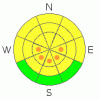
THREAT #1 |

|
| WHERE |
PROBABILITY |
SIZE |
TREND |
|
|
|
|
| |
|
|
Over the next
24 hours.
|
|
|
I'd expect to find fresh wind slabs on the lee sides of ridge lines and in terrain dictated deposition areas... Watch out for stiffer chalky looking snow on steep slopes. Harder wind slabs might allow you to get out on them before releasing.. In some areas, wind slabs probably formed on slopes with a buried persistent weak layer, and avalanches today may step down into older layers of snow. |
|
|
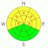
THREAT #2 |

|
| WHERE |
PROBABILITY |
SIZE |
TREND |
|
|
|
|
| |
|
|
Over the next
24 hours.
|
|
|
The February 10th surface hoar layer is gradually strengthening and avalanches are getting harder to find and more difficult to trigger. Persistent slab avalanches releasing on this layer now might not be as manageable or forgiving as they were previously. The danger of this type of avalanche is higher in un-disturbed or untracked terrain, like in the Mount Naomi and Wellsville Mountain Wildernesses. In some areas you still might might trigger a dangerous avalanche from a distance or from below.
Although now rather unlikely, dangerous deep slab avalanches are still possible on isolated steep slopes plagued by weak faceted snow in the basal layers of the snowpack. |
|
|
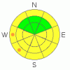
THREAT #3 |

|
| WHERE |
PROBABILITY |
SIZE |
TREND |
|
|
|
|
| |
|
|
Over the next
10 hours.
|
|
|
The sun might peek out for a while this afternoon, and with the aid of the seasonal high sun angle, warmth may again soften the already saturated snow on sunny and low elevation slopes even though the air temperature may not get all that hot. |
|
|
MOUNTAIN WEATHER |

|
Snowfall should taper off today, but upper elevation areas that do well under a northwest flow may pick up a few more inches of accumulation before it's all said and done.... Ridging tonight will bring partly cloudy skies over the region, calm winds, and fair and warmer weather tomorrow. We may pick up a few inches of snow late Sunday as the next Pacific storm again passes to our south..... |
|
|
GENERAL ANNOUNCEMENTS |
I will be issuing morning avalanche advisories for the Logan area on Mondays, Wednesdays, Fridays and Saturdays.
Consider purchasing some Beaver Mountain lift tickets here from our good friends at Backcountry.com in partnership with Ski Utah. All proceeds benefit the Friends of the Utah Avalanche Center.
If you want to get this avalanche advisory e-mailed to you daily click HERE.
Send us your avalanche and snow observations. You can also call me at 435-757-7578 or the SLC office at 800-662-4140, or email to uac@utahavalanchecenter.org
Donate to your favorite non-profit – The Friends of the Utah Avalanche Center. The UAC depends on contributions from users like you to support our work.
The information in this advisory is from the U.S. Forest Service, which is solely responsible for its content. This advisory describes general avalanche conditions and local variations always occur.
I will update this forecast Saturday morning. Thanks for checking in.... |
|
|
This information does not apply to developed ski areas or highways where avalanche control is normally done. This advisory is from the U.S.D.A. Forest Service, which is solely responsible for its content. This advisory describes general avalanche conditions and local variations always occur. |
|
This advisory provided by the USDA Forest Service, in partnership with:
The Friends of the Utah Avalanche Center, Utah Division of State Parks and Recreation, Utah Division of Emergency Management, Salt Lake County, Salt Lake Unified Fire Authority and the friends of the La Sal Avalanche Center. See our Sponsors Page for a complete list. |
