AVALANCHE WATCH »
The risk of an avalanche is expected to increase significantly
but the timing and location are still uncertain. Stay tuned for updates.
|
 |
Notice: New snow expected later today and into tonight could overload preexisting buried persistently weak snow and cause the avalanche danger to rise later today into Friday. If the storm produces the upper end of expected new snow amounts, human triggered avalanches will be likely on Friday. |
|
|
BOTTOM LINE
Danger by aspect and elevation on slopes approaching 35° or steeper.
(click HERE for tomorrow's danger rating)
|
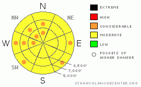
Danger Rose Tutorial
|
There's a MODERATE (2) danger, and triggered avalanches are possible on many steep slopes in the backcountry around Logan. Heightened avalanche conditions exist in shady steep upper and mid elevation terrain, in outlying areas like the Wellsville Mountain and Mount Naomi Wildernesses, and on any steep slope with moist or saturated snow. Expect the danger to rise with stormy weather conditions and/or warming today, and pockets with a CONSIDERABLE (3) danger will probably develop on many steep slopes by evening.
Careful snowpack evaluation, cautious route-finding and conservative decision-making are still essential for safe backcountry travel. |
|
|
CURRENT CONDITIONS |

|
You can find nice soft snow conditions on shady and sheltered slopes at mid and upper elevations.... Most other slopes are crusty or moist, depending on the temperature....The Tony Grove Snotel reports 3/10ths of an inch of water accumulation in the last 48 hrs, 70 inches of total snow containing 69% of average water for the date. It's 20 degrees and there's a fairly strong southeast wind up at the 9700' CSI weather station on Logan Peak, recording hourly averages in the mid-twenties..... |
|
|
RECENT ACTIVITY |

|
A snowmobiler was caught and his sled mostly buried in a good sized avalanche near Mantua on Sunday (2-28-10). Numerous natural loose wet avalanches occurred in the region in the last couple days, with lower and mid elevation west facing slopes most active... A good sized wet avalanche fell into Lower Green Canyon late yesterday (3-3-10) afternoon. The small group of avalanches started up high as point releases and then spread out in descent, encompassing a good portion of the slope before stopping a few feet shy of the winter trail head access road. I noticed some recently built jumps and lots of ski, board, and dog tracks in the area.
Here's an updated local backcountry avalanche list:
|
|
|
THREAT #1 |

|
| WHERE |
PROBABILITY |
SIZE |
TREND |

|
|
|
|
| |
|
|
Over the next
24 hours.
|
|
|
Southeast winds picked up overnight and we've picked up a little snow recently and more is expected today, so I'd expect to find fresh wind slabs on the lee sides of ridge lines and in terrain dictated deposition areas... Watch out for stiffer chalky looking snow on steep slopes. Harder wind slabs might allow you to get out on them before releasing.. In some areas, wind slabs may form on slopes with a buried persistent weak layer, and avalanches today may involve older layers of snow.
The avalanche danger will rise significantly overnight on slopes that receive significant deposits of new and especially drifted snow.... |
|
|
THREAT #2 |

|
| WHERE |
PROBABILITY |
SIZE |
TREND |

|
|
|
|
| |
|
|
Over the next
24 hours.
|
|
|
The February 10th surface hoar layer is gradually strengthening and avalanches are getting harder to find and more difficult to trigger. The problem is, persistent slab avalanches releasing on this layer now might not be as manageable or forgiving as last week's. The danger of this type of avalanche is higher in areas where slopes haven't been tested by human triggers and on slopes without old tracks, like those in the Mount Naomi and Wellsville Mountain Wildernesses. In some of these areas you still might might trigger a dangerous avalanche from a distance or from below. Today's storm could overload and reactivate buried weak layers...
Dangerous, deep slab avalanches are still possible in isolated areas, on steep slopes plagued by weak faceted snow in the basal layers of the snowpack. |
|
|
THREAT #3 |

|
| WHERE |
PROBABILITY |
SIZE |
TREND |
|
|
|
|
| |
|
|
Over the next
10 hours.
|
|
|
The sun might peek out for a while today and the March-high sun angle will soften the snow on sunny slopes even though the air temperature may not get all that hot. Cloud cover is likely to trap heat causing an enhanced greenhouse affect... Rain may fall on lower elevation slopes. Triggered wet avalanches are probable again today on steep slopes with saturated snow and a few naturals are possible if localized temperatures spike. |
|
|
MOUNTAIN WEATHER |

|
A fairly potent and moist Pacific storm is on track to hit northern Utah today with thunder, wind, and potentially significant snow accumulations in the mountains for tonight and into Friday. Expect light snowfall and southeast winds today, with conditions intensifying, a westerly wind shift, and possible convective (thunder storm) action in the afternoon.... Periods of heavy snowfall are likely tonight with storm total accumulations in the mountains of 1 to 1.5 feet quite possible.... Snowfall should taper off tomorrow. |
|
|
GENERAL ANNOUNCEMENTS |
I will be issuing morning avalanche advisories for the Logan area on Mondays, Wednesdays, Fridays and Saturdays.
Consider purchasing some Beaver Mountain lift tickets here from our good friends at Backcountry.com in partnership with Ski Utah. All proceeds benefit the Friends of the Utah Avalanche Center.
If you want to get this avalanche advisory e-mailed to you daily click HERE.
Send us your avalanche and snow observations. You can also call me at 435-757-7578 or the SLC office at 800-662-4140, or email to uac@utahavalanchecenter.org
Donate to your favorite non-profit – The Friends of the Utah Avalanche Center. The UAC depends on contributions from users like you to support our work.
The information in this advisory is from the U.S. Forest Service, which is solely responsible for its content. This advisory describes general avalanche conditions and local variations always occur.
I will update this forecast Friday morning. Thanks for checking in.... |
|
|
This information does not apply to developed ski areas or highways where avalanche control is normally done. This advisory is from the U.S.D.A. Forest Service, which is solely responsible for its content. This advisory describes general avalanche conditions and local variations always occur. |
|
This advisory provided by the USDA Forest Service, in partnership with:
The Friends of the Utah Avalanche Center, Utah Division of State Parks and Recreation, Utah Division of Emergency Management, Salt Lake County, Salt Lake Unified Fire Authority and the friends of the La Sal Avalanche Center. See our Sponsors Page for a complete list. |
