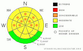
BOTTOM LINE
Danger by aspect and elevation on slopes approaching 35° or steeper.
(click HERE for tomorrow's danger rating)
|
Danger Rose Tutorial
|
There's a MODERATE (2) danger in the Central Bear River Range backcountry, and triggered wind slab and persistent slab avalanches 1 to 2 feet deep are possible on many slopes steeper than around 30 degrees. Pockets with a CONSIDERABLE (3) danger exist, especially in steep upper and mid elevation terrain exposed to wind drifting, and in outlying areas like the Wellsville Mountain and Mount Naomi Wildernesses. Very dangerous and much bigger deep slab avalanches are still possible on steep slopes plagued by weak sugary snow near the ground..
Careful snowpack evaluation, cautious route-finding and conservative decision-making are essential for safe backcountry travel. |
|
|
CURRENT CONDITIONS |

|
Yesterday afternoon, intensifying south winds and warming temperatures melted the rime off the wind sensor at Campbell Scientific weather station atop Logan Peak, and station recorded strong and sustained south winds overnight. This morning, south winds are cranking out 35 mph average wind speeds with gusts of near 50 out of the south, and its 22 degrees at 9700'.
the The Tony Grove Snotel reports 3/10ths of an inch of water accumulation in the last 48 hours,and there's now 74" of total snow on the ground containing 70% of average water for the date. |
|
|
RECENT ACTIVITY |

|
It was again a wild day in the Wasatch Backcountry with numerous natural and easily triggered avalanches reported to the Utah Avalanche Center...Yesterday several people took unintended rides in avalanches, and a couple survived after being partially buried, one with only his hand sticking out of the snow..... Our current conditions page has hours worth of recent accounts and scary photos from the last few days.....
Quieter locally; with no activity reported from the Logan Area since Monday, when a skier accidently triggered and was carried and partially buried by foot deep slab that broke just below his party on a northwest facing slope at around 8200' in upper Green Canyon...
Here's an updated local backcountry avalanche list:
|
|
|
THREAT #1 |

|
| WHERE |
PROBABILITY |
SIZE |
TREND |
|
|
|
|
| |
|
|
Over the next
24 hours.
|
|
|
A weak layer consisting of feathery frost crystals or surface hoar, buried and preserved by light snowfall on February 10th, is widespread across the region. This has been producing numerous triggered and natural avalanches since it was buried and even fairly minor additional snow loads seem capable of reactivating the weakness. Many recent triggered avalanches occurred on less steep than expected slopes. Slope angle estimates from these reported avalanches commonly range from 30 to 35 degrees. This weekend's persistent slab avalanches might not be as manageable or forgiving as last week's. You might trigger a dangerous avalanche from a distance or from below. |
|
|
THREAT #2 |

|
| WHERE |
PROBABILITY |
SIZE |
TREND |
|
|
|
|
| |
|
|
Over the next
24 hours.
|
|
|
Fairly strong and sustained south winds built and will continue to build stiff drifts in exposed terrain, and fresh wind slabs could be dangerously sensitive and somewhat solid. Watch for stiffer drifts or rounded chalky-looking deposits on the lee side of ridge-lines and in and around terrain features like cliff bands, gullies, and sub-ridges. A smaller wind slab avalanche overrunning a slope with existing buried weak layers might cause a much larger and more dangerous avalanche. |
|
|
THREAT #3 |

|
| WHERE |
PROBABILITY |
SIZE |
TREND |
|
|
|
|
| |
|
|
Over the next
10 hours.
|
|
|
Weak sugary or faceted snow near the ground is notoriously slow to heal, and last week's natural deep slab activity in the zone proves that a brood of dragons is still hanging around. I'm particularly concerned by huge natural deep slab avalanches on upper elevation east and west facing slopes in the Mount Naomi Wilderness..Like: Cougar Peak South Fork of High Creek
Deep slab avalanches might be initiated from a shallower area on the slab, so watch out for steep rocky or terrain with generally shallow snow cover. |
|
|
MOUNTAIN WEATHER |

|
A splitting storm will swing through the region today affecting mainly the southern mountains, but there should be enough moisture for an inch or so of accumulation in our area...Winds will shift from the east, temperatures should be around 30 degrees at 8500' and it'll be cloudy today and tomorrow...
A high pressure will build and the atmosphere will dry out early next week, with the next potential storm coming around Wednesday... |
|
|
GENERAL ANNOUNCEMENTS |
I will be issuing morning avalanche advisories for the Logan area on Mondays, Wednesdays, Fridays and Saturdays.
Consider purchasing some Beaver Mountain lift tickets here from our good friends at Backcountry.com in partnership with Ski Utah. All proceeds benefit the Friends of the Utah Avalanche Center.
If you want to get this avalanche advisory e-mailed to you daily click HERE.
Send us your avalanche and snow observations. You can also call me at 435-757-7578 or the SLC office at 800-662-4140, or email to uac@utahavalanchecenter.org
Donate to your favorite non-profit – The Friends of the Utah Avalanche Center. The UAC depends on contributions from users like you to support our work.
The information in this advisory is from the U.S. Forest Service, which is solely responsible for its content. This advisory describes general avalanche conditions and local variations always occur.
I will update this forecast Monday morning. Thanks for checking in.... |
|
|
This information does not apply to developed ski areas or highways where avalanche control is normally done. This advisory is from the U.S.D.A. Forest Service, which is solely responsible for its content. This advisory describes general avalanche conditions and local variations always occur. |
|
This advisory provided by the USDA Forest Service, in partnership with:
The Friends of the Utah Avalanche Center, Utah Division of State Parks and Recreation, Utah Division of Emergency Management, Salt Lake County, Salt Lake Unified Fire Authority and the friends of the La Sal Avalanche Center. See our Sponsors Page for a complete list. |
