SPECIAL ANNOUNCEMENT |
 |
The Utah Avalanche Center in Logan and Renegade Sports are teaming up to offer a FREE Avalanche Beacon Training Clinic on Tuesday, February 23rd from 5-7pm at Renegade Sports in Nibley. The clinic is open to everyone who wants to learn how to properly use an avalanche rescue beacon. Bring a friend or your family or your scout troop! It is an open house so come when you can. Remember, it's FREE and what you learn may save your life or the life of someone you know. For more info call 755-7111 or 757-2794. |
|
|
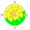
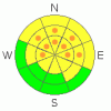
BOTTOM LINE
Danger by aspect and elevation on slopes approaching 35° or steeper.
(click HERE for tomorrow's danger rating)
|
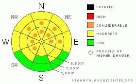
Danger Rose Tutorial
|
There's a MODERATE (2) avalanche danger, and dangerous triggered avalanches are possible on numerous slopes steeper than about 35 degrees in the backcountry around Logan. Pockets with a CONSIDERABLE (3) danger persist in steep terrain at upper and mid elevations, and you will likely trigger a dangerous avalanche if you venture onto the wrong steep slope. Triggered persistent slab avalanches 1 to 2 feet deep and 50 to 100 feet wide are still likely in some areas, and very dangerous and much bigger deep slab avalanches are still possible.
Careful snowpack evaluation, cautious route-finding and conservative decision-making are essential for safe backcountry travel. |
|
|
CURRENT CONDITIONS |

|
You can find nice soft snow conditions on shady slopes and crusts of varying thickness in the sun. With about an inch of snow in the past 24 hours, there's now 75" of total snow on the ground at the Tony Grove Snotel containing 68% of average water for the date. Its 2 degrees at the 9700' Campbell Scientific--Logan Peak weather station and a north-northeast wind is currently averaging 10 mph. |
|
|
RECENT ACTIVITY |

|
Yesterday was quite active in the Wasatch Range backcountry, with no less than 12 more human triggered avalanches involving around a foot of recently accumulated snow failing on a weak layer made up of feathery 2 dimensional frost crystals or small sugary grains, which is widespread across the region.
Locally; numerous avalanches were reported across the forecast zone in the last week..By far the vast majority of these involved the newest snow picked up since a nice layer of surface hoar was covered and preserved by light snow on Wednesday 2-10-10. A few very large natural deep slab avalanches became visible with brief clearing on upper elevation west facing slopes in the Mount Naomi Wilderness. A rider triggered a good sized soft slab off Cornice ridge over the weekend. Appears he was able to stay in the saddle and ride out of the avalanche. It was close to 2 feet deep and around 80 feet wide on a north facing slope at around 9400' in elevation.
Here's an updated local backcountry avalanche list:
|
|
|
THREAT #1 |

|
| WHERE |
PROBABILITY |
SIZE |
TREND |
|
|
|
|
| |
|
|
Over the next
24 hours.
|
|
|
Weak sugary or faceted snow near the ground is notoriously slow to heal, and recent natural deep slab activity in the zone proves that a brood of dragons is still hanging around. I'm particularly concerned by huge recent natural deep slab avalanches on upper elevation west facing slopes in the Mount Naomi Wilderness ..(Water Canyon 2-13-2010). (Cougar Peak 2-19?-2010)
Although the danger of deep slab avalanches is gradually diminishing, in some areas you still might trigger a dangerous avalanche from a distance or from below. Triggered deep slab avalanches could step down to weak snow near the ground and be very broad and destructive. Deep slab avalanches might be initiated from a shallower area on the slab, so watch out for steep rocky or terrain with generally shallow snow cover. Direct solar heating or green-housing, (with clouds and sunshine) may increase the creep rate of softening slabs, causing very large avalanches to be more likely on some slopes... |
|
|
THREAT #2 |

|
| WHERE |
PROBABILITY |
SIZE |
TREND |
|
|
|
|
| |
|
|
Over the next
24 hours.
|
|
|
A weak layer consisting of feathery frost crystals or small sugary grains is widespread across the region.....We've observed numerous triggered and natural avalanches on this persistent buried layer recently, and some of these avalanches occurred on fairly low angle slopes. The weakness is stabilizing gradually, which may actually make the situation more dangerous because slopes may allow you to get out on them before releasing... |
|
|
MOUNTAIN WEATHER |

|
Expect fair but chilly weather to continue today through tomorrow... Mountain temperatures should remain below 20 degrees in the shade today and drop back down into the single digits tonight... Gradually increasing southwest winds tomorrow will usher in warmer temperatures... Clouds should begin to build Tuesday night ahead of our next chance for a bit of snow on Wednesday. Models continue to give us a fair amount of moisture with this despite weakening and splitting dynamics.... Another slightly stronger storm is possible next weekend... |
|
|
GENERAL ANNOUNCEMENTS |
I will be issuing morning avalanche advisories for the Logan area on Mondays, Wednesdays, Fridays and Saturdays.
Consider purchasing some Beaver Mountain lift tickets here from our good friends at Backcountry.com in partnership with Ski Utah. All proceeds benefit the Friends of the Utah Avalanche Center.
If you want to get this avalanche advisory e-mailed to you daily click HERE.
Send us your avalanche and snow observations. You can also call me at 435-757-7578 or the SLC office at 800-662-4140, or email to uac@utahavalanchecenter.org
Donate to your favorite non-profit – The Friends of the Utah Avalanche Center. The UAC depends on contributions from users like you to support our work.
The information in this advisory is from the U.S. Forest Service, which is solely responsible for its content. This advisory describes general avalanche conditions and local variations always occur.
I will update this forecast Wednesday morning. Thanks for checking in.... |
|
|
This information does not apply to developed ski areas or highways where avalanche control is normally done. This advisory is from the U.S.D.A. Forest Service, which is solely responsible for its content. This advisory describes general avalanche conditions and local variations always occur. |
|
This advisory provided by the USDA Forest Service, in partnership with:
The Friends of the Utah Avalanche Center, Utah Division of State Parks and Recreation, Utah Division of Emergency Management, Salt Lake County, Salt Lake Unified Fire Authority and the friends of the La Sal Avalanche Center. See our Sponsors Page for a complete list. |
