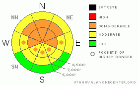
BOTTOM LINE
Danger by aspect and elevation on slopes approaching 35° or steeper.
(click HERE for tomorrow's danger rating)
|
Danger Rose Tutorial
|
There's still a CONSIDERABLE (3) danger, and dangerous avalanche conditions exist in the backcountry around Logan. Triggered avalanches 1 to 3 feet deep are probable on upper and mid-elevation slopes approaching or steeper than about 35 degrees. In some areas, particularly in areas with shallow snow cover and where weak snow still plagues the basal layers of the snowpack, you might trigger a very dangerous deep slab avalanche. Although the recent instability is becoming less sensitive, you might still trigger some avalanches remotely or from below.....
Careful snowpack evaluation, cautious route-finding and conservative decision-making are essential for safe backcountry travel today. |
|
|
CURRENT CONDITIONS |

|
The Tony Grove Snotel at 8400' a couple inches of new snow and .4 inches of water in the last 48 hours. This is stacked on top of an active surface hoar or frost layer formed early last week and preserved by light density snowfall . There's now 76" of total snow on the ground containing 70% of average water for the date. Its 18 degrees at the 9700' Campbell Scientific--Logan Peak weather station, and the wind is out of the north-northwest, averaging around 12 mph. |
|
|
RECENT ACTIVITY |

|
Yesterday was quite active in the Wasatch Range backcountry, with 15 or 20 reports of solar warming related and human triggered avalanches involving fresh snow accumulated over the last week failing on frost or surface hoar, which is widespread across the region.
Locally; numerous natural and easily or remote triggered avalanches reported across the forecast zone over the weekend....By far the vast majority of these avalanches involved the newest layer of snow picked up since a nice layer of surface hoar was covered and preserved by light snow on Wednesday 2-10-10. A couple more unintentionally triggered avalanches reported Monday, with a close call in Tab Hollow. A foot-deep soft slab avalanche broke 60 to 80 feet above a skier, who was able to self arrest on the bed surface, as the snow washed by.
Here's an updated local backcountry avalanche list:
|
|
|
THREAT #1 |

|
| WHERE |
PROBABILITY |
SIZE |
TREND |

|
|
|
|
| |
|
|
Over the next
24 hours.
|
|
|
A weak layer consisting of surface hoar or frost, now buried under a foot or so of snow, is widespread across the region.....We've observed numerous easily and remotely triggered and natural avalanches on this persistent buried layer, and some of these occurred on fairly low angle slopes... |
|
|
THREAT #2 |

|
| WHERE |
PROBABILITY |
SIZE |
TREND |

|
|
|
|
| |
|
|
Over the next
24 hours.
|
|
|
The now deeply buried weak sugary or faceted snow is notoriously slow to heal, and recent natural deep slab activity in the area proves that this dragon is still hanging around...(Water Canyon 2-13-2010). Deep slab avalanches can most easily be initiated from a shallower area on the slab, so watch out for steep rocky or terrain with generally shallow snow cover. In some areas, you still might trigger a dangerous avalanche from a distance or from below. Triggered deep slab avalanches will step down to weak snow near the ground and be very broad and destructive. The weight of a smaller avalanche overrunning a slope with a poor snow structure could cause a much larger and more dangerous avalanche. |
|
|
MOUNTAIN WEATHER |

|
Winds are moderate out of the north-northwest this morning. Mountain temperatures should stay fairly constant in the mid twenties today. Light snowfall will resume in the mountains this afternoon, as as a cold front begins to drop through Utah from the north. We'll likely see a decent shot of accumulation before tomorrow night, with around 6 inches forecast. |
|
|
GENERAL ANNOUNCEMENTS |
I will be issuing morning avalanche advisories for the Logan area on Mondays, Wednesdays, Fridays and Saturdays.
Consider purchasing some Beaver Mountain lift tickets here from our good friends at Backcountry.com in partnership with Ski Utah. All proceeds benefit the Friends of the Utah Avalanche Center.
If you want to get this avalanche advisory e-mailed to you daily click HERE.
Send us your avalanche and snow observations. You can also call me at 435-757-7578 or the SLC office at 800-662-4140, or email to uac@utahavalanchecenter.org
Donate to your favorite non-profit – The Friends of the Utah Avalanche Center. The UAC depends on contributions from users like you to support our work.
The information in this advisory is from the U.S. Forest Service, which is solely responsible for its content. This advisory describes general avalanche conditions and local variations always occur.
I will update this forecast Friday morning. Thanks for checking in.... |
|
|
This information does not apply to developed ski areas or highways where avalanche control is normally done. This advisory is from the U.S.D.A. Forest Service, which is solely responsible for its content. This advisory describes general avalanche conditions and local variations always occur. |
|
This advisory provided by the USDA Forest Service, in partnership with:
The Friends of the Utah Avalanche Center, Utah Division of State Parks and Recreation, Utah Division of Emergency Management, Salt Lake County, Salt Lake Unified Fire Authority and the friends of the La Sal Avalanche Center. See our Sponsors Page for a complete list. |
