SPECIAL ANNOUNCEMENT |
 |
We've issued a Special Avalanche Advisory on Sunday, February 14th. Recent new snow over the last few days has covered up some very weak snow formed earlier in the week which has produced widespread avalanche activity. This weakness is expected to be active again today with human triggered avalanches likely on slopes approaching 30 degrees and steeper.
|
|
|
BOTTOM LINE
Danger by aspect and elevation on slopes approaching 35° or steeper.
(click HERE for tomorrow's danger rating)
|
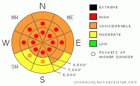
Danger Rose Tutorial
|
Overall a CONSIDERABLE (3) danger, and easily triggered storm snow, wind slab, and persistent slab avalanches 1 to 2 feet deep are likely on slopes steeper than about 30 degrees. There are pockets with a HIGH (4) danger on steep upper and mid elevation slopes with significant deposits of new and especially wind drifted snow. In some areas, where weak snow still plagues the basal layers of the snowpack, you might trigger a very dangerous deep slab avalanche. Deep slabs will most likely be triggered from generally shallow areas, and a smaller avalanche overrunning a slope with weak snow structure could cause a much larger and more destructive avalanche... You could trigger avalanches remotely, from a good distance, or from below.....
Careful snowpack evaluation, cautious route-finding and conservative decision-making are essential for safe backcountry travel today. Avoid travel on or under steep slopes and obvious or historic avalanche paths. |
|
|
CURRENT CONDITIONS |

|
This morning, the Tony Grove Snotel at 8400' reports several more inches of new snow, with 1.9" of water accumulated in the last 48 hours, and nearly 2.5 inches of water now capping a weak surface hoar or frost layer formed earlier in the week and preserved by light density snowfall on Wednesday. There's now 79" of total snow on the ground containing 70% of average water for the date. Its 13 degrees this morning at the 9700' Campbell Scientific--Logan Peak weather station, and north winds are averaging around 10 mph. |
|
|
RECENT ACTIVITY |

|
If you head out into the backcountry, keep in mind that we've had near misses and sometimes a handful of near misses on most weekend days in 2010.. Simple math tells us that our luck is bound to run out if we keep up this trend
Riders triggered three large deep slab avalanches in the Logan Peak Area last weekend. Everyone appears to have been clear of the slopes when the dangerous avalanches released, and no one was caught. Friday, we noted natural and very easily triggered soft slab avalanches up to around a foot deep in the Tony Grove Area.
On Saturday, 2 different parties of backcountry skiers unintentionally and easily triggered avalanches in the Dog Leg off of "Long Mountain" in Providence Canyon, and nearby trees to the east. The Dog Leg, a north facing avalanche path topping out at 8900' in elevation, ran well over 1250' vrt widening significantly as it dropped over the steep lower head-wall, and depositing a good deal of snow on the bench below....
Here's an updated local backcountry avalanche list:
|
|
|
THREAT #1 |

|
| WHERE |
PROBABILITY |
SIZE |
TREND |
|
|
|
|
| |
|
|
Over the next
24 hours.
|
|
|
Surface hoar or frost was observed earlier in the week from the valley floors to the highest ridgetops across the region.....We've observed easily and remotely triggered and natural avalanches stepping down to this persistent buried layer, and some of these are occurring on fairly low angle slopes... With today's additional new snow and fairly strong northwest winds, I expect both natural and triggered avalanches on slopes with significant deposits of new or especially drifted snow.....
Watch for and avoid fresh drifts on the lee side of exposed ridges and in and around terrain features like gullies or sub-ridges. Keep in mind that the weight of a smaller avalanche overrunning a slope with a poor snow structure could cause a much larger and more dangerous avalanche. |
|
|
THREAT #2 |

|
| WHERE |
PROBABILITY |
SIZE |
TREND |
|
|
|
|
| |
|
|
Over the next
24 hours.
|
|
|
Although many slopes already slid and others appear to be gradually stabilizing, the now deeply buried weak sugary or faceted snow is notoriously slow to heal, and I'm still feeling pretty uneasy in the backcountry these days. .. Very dangerous, triggered deep slab avalanches are still possible in steep terrain that didn't recently avalanche. These dangerous monsters can most easily be initiated from a shallower area on the slab, so watch out for steep rocky or terrain with generally shallow snow cover. In some areas, you still might trigger a dangerous avalanche from a distance or from below. Triggered deep slab avalanches could step down to weak snow near the ground and be very broad and destructive. |
|
|
MOUNTAIN WEATHER |

|
Winds are moderate out of the north this morning and they should diminish a bit before shifting around from the west and southwest later this afternoon. Mountain temperatures should rebound to around 30 degrees today. Expect the somewhat moist northwest flow to continue for the next few days, with the next potential organized storm system in the middle of next week. |
|
|
GENERAL ANNOUNCEMENTS |
I will be issuing morning avalanche advisories for the Logan area on Mondays, Wednesdays, Fridays and Saturdays.
Consider purchasing some Beaver Mountain lift tickets here from our good friends at Backcountry.com in partnership with Ski Utah. All proceeds benefit the Friends of the Utah Avalanche Center.
If you want to get this avalanche advisory e-mailed to you daily click HERE.
Send us your avalanche and snow observations. You can also call me at 435-757-7578 or the SLC office at 800-662-4140, or email to uac@utahavalanchecenter.org
Donate to your favorite non-profit – The Friends of the Utah Avalanche Center. The UAC depends on contributions from users like you to support our work.
The information in this advisory is from the U.S. Forest Service, which is solely responsible for its content. This advisory describes general avalanche conditions and local variations always occur.
I will update this forecast Monday morning. Thanks for checking in.... |
|
|
This information does not apply to developed ski areas or highways where avalanche control is normally done. This advisory is from the U.S.D.A. Forest Service, which is solely responsible for its content. This advisory describes general avalanche conditions and local variations always occur. |
|
This advisory provided by the USDA Forest Service, in partnership with:
The Friends of the Utah Avalanche Center, Utah Division of State Parks and Recreation, Utah Division of Emergency Management, Salt Lake County, Salt Lake Unified Fire Authority and the friends of the La Sal Avalanche Center. See our Sponsors Page for a complete list. |
