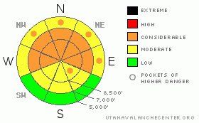
BOTTOM LINE
Danger by aspect and elevation on slopes approaching 35° or steeper.
(click HERE for tomorrow's danger rating)
|
Danger Rose Tutorial
|
The overall danger in the backcountry is CONSIDERABLE (or level 3). As we head into the weekend, the danger is rising due to additional snowfall, rising temperatures, and intensifying southwest winds. Triggered storm snow, wind slabs, or persistent slab avalanches are likely today, particularly on shady and/or drifted slopes steeper than about 30 degrees. Deep slab avalanches are becoming harder to initiate, but especially in areas where the existing slab is shallower, you still might trigger a very dangerous deep slab avalanche 3 to 6 feet deep, and potentially quite wide. A smaller avalanche overrunning a slope with weak snow structure could cause a much larger and more destructive avalanche....
Careful snowpack evaluation, cautious route-finding and conservative decision-making are essential for safe backcountry travel today. |
|
|
CURRENT CONDITIONS |

|
The Tony Grove Snotel at 8400' reports several inches of new snow, with .7" of water accumulated in the last 48 hours. There's now 73" of total snow on the ground containing 65% of average water for the date. The Campbell Scientific--Logan Peak weather station recorded increasing temperatures and intensifying southwest winds overnight. Southwest winds are now averaging around 23 mph this morning, and its 17 degrees at 9700'. |
|
|
RECENT ACTIVITY |

|
As we head into yet another weekend with dangerous avalanche conditions in the backcountry, we should keep in mind that we've had near misses and sometimes a handful of near misses on weekend days in 2010...Avalanches come in all shapes and sizes, and just because you got 'er turned and out ran last week's slide doesn't mean you'll hit it right every time... You've been rolling the dice boys, and somehow staying in the saddle. But if you keep pushing it, the luck is likely to run out sometime.
Riders triggered three large deep slab avalanches in the Logan Peak Area last weekend. All the riders appear to have been clear of the slopes when the dangerous avalanches released, and no one was caught. Yesterday, powder riders triggered numerous manageable but quite sensitive soft slab avalanches up to around a foot deep in the Tony Grove Area.
Here's an updated local backcountry avalanche list:
|
|
|
THREAT #1 |

|
| WHERE |
PROBABILITY |
SIZE |
TREND |

|
|
|
|
| |
|
|
Over the next
24 hours.
|
|
|
Surface hoar or frost was observed earlier in the week from the valley floors to the highest ridgetops across the region.....Recent triggered avalanches stepping down to this persistent buried layer of surface hoar or frost have been reported in the Providence Canyon and Tony Grove Areas, and some of these have apparently been occurring on fairly low angle slopes... With today's new snow and increasing southwest wind, wind slab and storm snow avalanches will likely become more widespread and easier to trigger.
Watch for and avoid fresh drifts on the lee side of exposed ridges and in and around terrain features like gullies or sub-ridges. Keep in mind that the weight of a smaller avalanche overrunning a slope with an unstable snow structure could cause a much larger and more dangerous avalanche. |
|
|
THREAT #2 |

|
| WHERE |
PROBABILITY |
SIZE |
TREND |

|
|
|
|
| |
|
|
Over the next
24 hours.
|
|
|
Although many slopes already slid and others appear to be gradually stabilizing, the now deeply buried weak sugary or faceted snow is notoriously slow to heal, and I'm still feeling pretty uneasy in the backcountry these days. .. Very dangerous, triggered deep slab avalanches are still possible in steep terrain that didn't recently avalanche. These dangerous monsters can most easily be initiated from a shallower area on the slab, so watch out for steep rocky or terrain with generally shallow snow cover. In some areas, you still might trigger a dangerous avalanche from a distance or from below. Triggered deep slab avalanches could step down to weak snow near the ground and be very broad and destructive. |
|
|
MOUNTAIN WEATHER |

|
We'll see more snow in the Bear River Range today, and there is potential for a decent shot for our region, as the storm is favoring the far northern Utah mountains. Another similar wave of storminess will affect our region tomorrow, with a few more inches of accumulation forecast.... |
|
|
GENERAL ANNOUNCEMENTS |
I will be issuing morning avalanche advisories for the Logan area on Mondays, Wednesdays, Fridays and Saturdays.
Consider purchasing some Beaver Mountain lift tickets here from our good friends at Backcountry.com in partnership with Ski Utah. All proceeds benefit the Friends of the Utah Avalanche Center.
If you want to get this avalanche advisory e-mailed to you daily click HERE.
Send us your avalanche and snow observations. You can also call me at 435-757-7578 or the SLC office at 800-662-4140, or email to uac@utahavalanchecenter.org
Donate to your favorite non-profit – The Friends of the Utah Avalanche Center. The UAC depends on contributions from users like you to support our work.
The information in this advisory is from the U.S. Forest Service, which is solely responsible for its content. This advisory describes general avalanche conditions and local variations always occur.
I will update this forecast Saturday morning. Thanks for checking in.... |
|
|
This information does not apply to developed ski areas or highways where avalanche control is normally done. This advisory is from the U.S.D.A. Forest Service, which is solely responsible for its content. This advisory describes general avalanche conditions and local variations always occur. |
|
This advisory provided by the USDA Forest Service, in partnership with:
The Friends of the Utah Avalanche Center, Utah Division of State Parks and Recreation, Utah Division of Emergency Management, Salt Lake County, Salt Lake Unified Fire Authority and the friends of the La Sal Avalanche Center. See our Sponsors Page for a complete list. |
