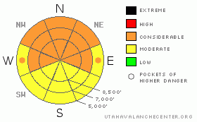
BOTTOM LINE
Danger by aspect and elevation on slopes approaching 35° or steeper.
(click HERE for tomorrow's danger rating)
|
Danger Rose Tutorial
|
The overall danger in the backcountry is still CONSIDERABLE (or level 3), which means that dangerous and potentially deadly avalanche conditions linger on many slopes in the region. You could trigger a very dangerous deep slab avalanche 3 to 6 feet deep, or deeper, and potentially quite wide on slopes with preexisting weak snow that haven't recently avalanched. Triggered wind or persistent slab avalanches are probable in some areas, particularly on shady and/or drifted slopes steeper than about 30 degrees. Wet avalanches are also possible in the heat of the day on sunny steep lower elevation slopes with moist or saturated surface snow.
Careful snowpack evaluation, cautious route-finding and conservative decision-making are essential for safe backcountry travel travel today. |
|
|
CURRENT CONDITIONS |

|
You can still find good soft snow conditions on slopes facing the northern half of the compass, but these are also areas with lingering avalanche danger. I found sunny mid elevation slopes crusty and difficult yesterday afternoon.
The Tony Grove Snotel at 8400' reports 71" of total snow on the ground, the station is reporting 64% of average water for the date. The Campbell Scientific--Logan Peak weather station recorded fairly light northeast winds overnight, now averaging around 8 mph, and its 12 degrees at 9700' |
|
|
RECENT ACTIVITY |

|
There were several avalanche accidents in the Central Wasatch backcountry yesterday, with people taking long rides and sustaining serious injuries in large avalanche incidents. Current Conditions Page
Locally, riders report remote? triggering a large deep slab avalanche just east of upper Providence Canyon on Saturday. Luckily, the riders were clear of the slope when it released, and no one was caught. A good sized deep slab either naturally released or was remote triggered from a good distance midday yesterday just up canyon from the Temple Fork intersection in Logan Canyon. The avalanche at 6000' on a northeast facing slope was on an adjacent slope to the one that closed Logan Canyon Highway exactly two weeks ago. This one stopped in thick trees a few feet shy of the road.
Here's an updated local backcountry avalanche list:
|
|
|
THREAT #1 |

|
| WHERE |
PROBABILITY |
SIZE |
TREND |
|
|
|
|
| |
|
|
Over the next
24 hours.
|
|
|
The now deeply buried weak sugary or faceted snow is slow to heal, and I'm still feeling pretty nervous in the backcountry these days. Very dangerous, triggered deep slab avalanches are still possible in steep terrain that didn't recently avalanche. In some areas, you might trigger a dangerous avalanche from a distance or from below. Triggered deep slab avalanches could step down to weak snow near the ground and be very broad and destructive. Recent large avalanches in the region have been running far, many close to the fullest extent of their paths. |
|
|
THREAT #2 |

|
| WHERE |
PROBABILITY |
SIZE |
TREND |

|
|
|
|
| |
|
|
Over the next
24 hours.
|
|
|
Watch for and avoid sensitive wind slabs on the lee side of exposed ridges and in and around terrain features like gullies or sub-ridges.... Recent triggered avalanches stepping down to a buried layer of surface hoar or frost have been reported in the Ogden and Davis County Mountains in the last few days, some of these have been on fairly low angle slopes.... |
|
|
THREAT #3 |

|
| WHERE |
PROBABILITY |
SIZE |
TREND |

|
|
|
|
| |
|
|
Over the next
10 hours.
|
|
|
Could see some wet activity on steep sunny lower elevation slopes. Avoid steep slopes with moist or gloppy snow in the middle of the day..... |
|
|
MOUNTAIN WEATHER |

|
Expect fair and sunny weather in the mountains today and tomorrow with high temperatures in the mid twenties. Another storm system will slide by to our south in the middle of the week with little in the way of snow forecast up north. |
|
|
GENERAL ANNOUNCEMENTS |
I will be issuing morning avalanche advisories for the Logan area on Mondays, Wednesdays, Fridays and Saturdays.
Consider purchasing some Beaver Mountain lift tickets here from our good friends at Backcountry.com in partnership with Ski Utah. All proceeds benefit the Friends of the Utah Avalanche Center.
If you want to get this avalanche advisory e-mailed to you daily click HERE.
Send us your avalanche and snow observations. You can also call me at 435-757-7578 or the SLC office at 800-662-4140, or email to uac@utahavalanchecenter.org
Donate to your favorite non-profit – The Friends of the Utah Avalanche Center. The UAC depends on contributions from users like you to support our work.
The information in this advisory is from the U.S. Forest Service, which is solely responsible for its content. This advisory describes general avalanche conditions and local variations always occur.
I will update this forecast Wednesday morning. Thanks for checking in.... |
|
|
This information does not apply to developed ski areas or highways where avalanche control is normally done. This advisory is from the U.S.D.A. Forest Service, which is solely responsible for its content. This advisory describes general avalanche conditions and local variations always occur. |
|
This advisory provided by the USDA Forest Service, in partnership with:
The Friends of the Utah Avalanche Center, Utah Division of State Parks and Recreation, Utah Division of Emergency Management, Salt Lake County, Salt Lake Unified Fire Authority and the friends of the La Sal Avalanche Center. See our Sponsors Page for a complete list. |
