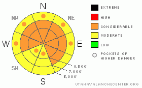
BOTTOM LINE
Danger by aspect and elevation on slopes approaching 35° or steeper.
(click HERE for tomorrow's danger rating)
|
Danger Rose Tutorial
|
The overall danger in the backcountry is CONSIDERABLE (3), which means that dangerous and potentially deadly avalanche conditions linger on many slopes in the region. You could trigger a nasty hard slab avalanche 3 to 6 feet deep, or deeper, and potentially quite wide on slopes with preexisting weak snow that haven't recently avalanched. Any triggered deep slab avalanche is likely to be huge, long running and very dangerous. Triggered wind slab or storm snow avalanches are also probable on drifted upper elevation slopes steeper than about 35 degrees, and wet avalanches are possible on steep lower elevation slopes with moist or saturated surface snow..
Careful snowpack evaluation, cautious route-finding and conservative decision-making are essential for safe backcountry travel travel today. I plan to avoid and stay out from under steep slopes and avalanche paths that haven't recently avalanched. |
|
|
CURRENT CONDITIONS |

|
Looks like a few inches of wet snow fell overnight, with perhaps a bit more this time in the Wellsvilles and Southern Bear River Range. The Tony Grove Snotel at 8400' reports a couple inches of heavy snow overnight, containing a solid half inch of water equivalent. With 73" of total snow on the ground, the station is reporting 66% of average water for the date. The Campbell Scientific--Logan Peak wind sensor recorded diminishing northwest winds overnight, now averaging around 8 mph. Its 20 degrees at 9700' |
|
|
RECENT ACTIVITY |

|
It's been five days since our last cycle of large natural hard slab avalanches and a week since a handful of close-calls with very big and dangerous rider-triggered hard slab avalanches last weekend up in the Tony Grove and Providence Canyon Areas... The recent avalanches I've been looking at have been 4 to 6 feet deep and a few hundred feet wide or quite a bit more.
Here's an updated local backcountry avalanche list:
|
|
|
THREAT #1 |

|
| WHERE |
PROBABILITY |
SIZE |
TREND |

|
|
|
|
| |
|
|
Over the next
24 hours.
|
|
|
The now deeply buried weak sugary or faceted snow is slow to heal, and I'm still feeling pretty edgy in the backcountry these days. Very dangerous, triggered deep slab avalanches are again possible this weekend in steep terrain that didn't recently avalanche. In some areas, you might trigger a dangerous avalanche from a distance or from below. Triggered deep slab avalanches could step down to weak snow near the ground and be very broad and destructive. Recent large avalanches in the region have been running far, many close to the fullest extent of their paths.
|
|
|
THREAT #2 |

|
| WHERE |
PROBABILITY |
SIZE |
TREND |
|
|
|
|
| |
|
|
Over the next
24 hours.
|
|
|
Watch for and avoid sensitive wind slabs on the lee side of exposed ridges and in and around terrain features like gullies or sub-ridges...Additional accumulations today will likely also be susceptible to drifting. Smaller storm snow or wind slab avalanches overrunning slopes with deeply buried weak snow could produce a much larger and more dangerous avalanche.... |
|
|
THREAT #3 |

|
| WHERE |
PROBABILITY |
SIZE |
TREND |

|
|
|
|
| |
|
|
Over the next
10 hours.
|
|
|
Could see some wet activity on steep lower elevation slopes, with a fairly high rain/snow line and potential solar warming or green-housing this afternoon....Gloppy fresh snow is susceptible to wet avalanching. A wet avalanche might gouge down or step into weak old snow and become large quickly.
|
|
|
MOUNTAIN WEATHER |

|
...Snowfall should taper off in our area after another potential round this morning with daytime warming, and another inch or two of accumulation is possible in the mountains today. Expect a fairly warm afternoon, and if the sun peaks out of clouds for a time, the warming could be somewhat dramatic, especially in sheltered lower elevation terrain. Another round of snowfall is likely tonight, but most of the storm energy will be to our south, with only a couple inches of accumulation expected in the northern mountains. A high pressure system will build into the region early next week.
|
|
|
GENERAL ANNOUNCEMENTS |
I will be issuing morning avalanche advisories for the Logan area on Mondays, Wednesdays, Fridays and Saturdays.
Consider purchasing some Beaver Mountain lift tickets here from our good friends at Backcountry.com in partnership with Ski Utah. All proceeds benefit the Friends of the Utah Avalanche Center.
If you want to get this avalanche advisory e-mailed to you daily click HERE.
Send us your avalanche and snow observations. You can also call me at 435-757-7578 or the SLC office at 800-662-4140, or email to uac@utahavalanchecenter.org
Donate to your favorite non-profit – The Friends of the Utah Avalanche Center. The UAC depends on contributions from users like you to support our work.
The information in this advisory is from the U.S. Forest Service, which is solely responsible for its content. This advisory describes general avalanche conditions and local variations always occur.
I will update this forecast Monday morning. Thanks for checking in.... |
|
|
This information does not apply to developed ski areas or highways where avalanche control is normally done. This advisory is from the U.S.D.A. Forest Service, which is solely responsible for its content. This advisory describes general avalanche conditions and local variations always occur. |
|
This advisory provided by the USDA Forest Service, in partnership with:
The Friends of the Utah Avalanche Center, Utah Division of State Parks and Recreation, Utah Division of Emergency Management, Salt Lake County, Salt Lake Unified Fire Authority and the friends of the La Sal Avalanche Center. See our Sponsors Page for a complete list. |
