BOTTOM LINE
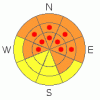
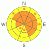
Danger by aspect and elevation on slopes approaching 35° or steeper.
(click HERE for tomorrow's danger rating)
|

Danger Rose Tutorial
|
The overall danger in the backcountry is on the high end of CONSIDERABLE (3), which means that dangerous and potentially deadly avalanche conditions exist on many slopes. Triggered wind slab avalanches are still probable on slopes steeper than about 35 degrees with significant deposits of recently drifted snow. On slopes that haven't recently avalanched, you could trigger a deadly hard slab avalanche 3 to 6 feet deep or deeper and potentially quite wide in steep terrain with preexisting weak snow. I've included pockets of HIGH(4) danger on many mid and and upper elevation slopes, since any triggered deep slab avalanche is likely to be huge and very dangerous. The danger is probably higher in the Central Bear River Range where significantly more snow accumulated with Sunday's productive storm.
Careful snowpack evaluation, cautious route-finding and conservative decision-making are essential for safe backcountry travel travel today, and continue to avoid and stay out from under steep slopes and avalanche paths that haven't recently avalanched. |
|
|
CURRENT CONDITIONS |

|
Sunday's storm was quite productive for the Central Bear River Range, depositing 1.5 to 3 feet of snow on slopes at all elevations...Less snow fell from about Logan Canyon south. The Tony Grove Snotel at 8400' reported 2.4 inches of water in well over 2 feet of new snow. Now with 73" of total snow on the ground, the station is reporting 65% of average water for the date. The CSI Logan Peak wind sensor recorded 20 mph south winds overnight, and its 20 degrees at 9700' |
|
|
RECENT ACTIVITY |

|
Huge, long running natural hard slab avalanches from 1-23,24-2010 several feet deep were visible from the air across the Logan forecast zone last week, several half-a-mile wide or wider. Most of the deep slab activity occurred on northwest through east facing slopes, with a couple notable exceptions on southeast and west facing slopes. I've posted some of our aerial observations from 1-28-10 here… Another natural cycle occurred overnight of 2-1-10, with several notable huge hard slab releases in the Central Bear River Range including very large avalanches in Wood Camp and Steep Hollows....
Locally: A close-call was reported from midday Saturday, 1-30-10, in the Tony Grove Area. A rider triggered a very large deep slab avalanche that ran fairly far. It stopped just before reaching the rest of his party watching from the flats below. The avalanche, on a mostly east facing slope at around 8400' in elevation was estimated to be 4 to 6 feet deep and the length of a football field at the crown... Also, a rider triggered a broad deep slab avalanche Saturday in the Rodeo Grounds in upper Providence Canyon and took a fairly long ride, but luckily ended up on the surface.
Here's an updated local backcountry avalanche list:
|
|
|
THREAT #1 |

|
| WHERE |
PROBABILITY |
SIZE |
TREND |

|
|
|
|
| |
|
|
Over the next
24 hours.
|
|
|
Deep slab avalanches are probable today in steep terrain that didn't recently avalanche. On Sunday once again, lots of new snow overloaded slopes plagued by existing weak sugary layers, and another natural avalanche cycle occurred across the Logan Forecast Zone, with very wide and destructive hard slab releases on slopes that hadn't recently avalanched in the Bear River Range north and west of Logan Canyon.
In some areas, you could still trigger a dangerous avalanche from a distance or from below. Triggered deep slab avalanches could step down to weak snow near the ground and be very broad and destructive. Smaller storm snow or wind slab avalanches overrunning slopes with deeply buried weak snow could produce a much larger and more dangerous avalanche. Keep in mind that recent avalanches in the region have been running far, many to the fullest extent of their paths. |
|
|
THREAT #2 |

|
| WHERE |
PROBABILITY |
SIZE |
TREND |

|
|
|
|
| |
|
|
Over the next
24 hours.
|
|
|
Sunday's storm caused a general upswing in avalanche danger and complexity, and triggered wind slab avalanches up to 2 feet deep, running on storm interface weakness or gradually strengthening surface hoar (frost) are still probable on many steep drifted slopes. Tonight's storm will also cause a rise in overall danger and especially on slopes that receive significant deposits of drifted or heavy new snow. |
|
|
MOUNTAIN WEATHER |

|
Tonight's storm may again favor the north, with currently 3 to 7 inches of accumulation forecast...Snowfall, under a southwest flow, should begin later this afternoon and taper off tomorrow morning. This may cause a rise in avalanche danger in the backcountry Expect continued moist weather but little accumulation through the weekend..... |
|
|
GENERAL ANNOUNCEMENTS |
I will be issuing morning avalanche advisories for the Logan area on Mondays, Wednesdays, Fridays and Saturdays.
Consider purchasing some Beaver Mountain lift tickets here from our good friends at Backcountry.com in partnership with Ski Utah. All proceeds benefit the Friends of the Utah Avalanche Center.
If you want to get this avalanche advisory e-mailed to you daily click HERE.
Send us your avalanche and snow observations. You can also call me at 435-757-7578 or the SLC office at 800-662-4140, or email to uac@utahavalanchecenter.org
Donate to your favorite non-profit – The Friends of the Utah Avalanche Center. The UAC depends on contributions from users like you to support our work.
The information in this advisory is from the U.S. Forest Service, which is solely responsible for its content. This advisory describes general avalanche conditions and local variations always occur.
I will update this forecast Friday morning. Thanks for checking in.... |
|
|
This information does not apply to developed ski areas or highways where avalanche control is normally done. This advisory is from the U.S.D.A. Forest Service, which is solely responsible for its content. This advisory describes general avalanche conditions and local variations always occur. |
|
This advisory provided by the USDA Forest Service, in partnership with:
The Friends of the Utah Avalanche Center, Utah Division of State Parks and Recreation, Utah Division of Emergency Management, Salt Lake County, Salt Lake Unified Fire Authority and the friends of the La Sal Avalanche Center. See our Sponsors Page for a complete list. |


