SPECIAL ANNOUNCEMENT |
 |
A Special Avalanche Advisory continues for the mountains of Utah with a particular Warning in the Logan area mountains. Deep unsurvivable avalanches may be triggered on a variety of aspects and elevations. We have had three avalanche fatalities in the backcountry this last week alone…Those without expert level avalanche skill should avoid being on, under, or adjacent to steep slopes.
|
|
|
BOTTOM LINE
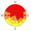
Danger by aspect and elevation on slopes approaching 35° or steeper.
(click HERE for tomorrow's danger rating)
|
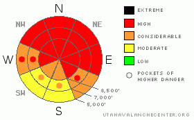
Danger Rose Tutorial
|
Yesterday's very productive storm pushed the avalanche danger back up to HIGH on many steep slopes and at all elevations in the backcountry around Logan. Triggered and natural wind slab and storm snow avalanches are likely on slopes steeper than about 30 degrees with significant deposits of new or especially wind-drifted snow. Avalanches are possible today in drifted low elevation terrain like the foothills and benches where you normally might not expect to find a problem... You could trigger a deadly hard slab avalanche 3 to 6 feet deep or deeper and potentially quite wide in steep terrain with preexisting weak snow. Smaller storm snow or wind slab avalanches overrunning slopes with a deeply buried weak layer could produce a much larger and more dangerous avalanche. Also in these conditions, you might trigger avalanches from a distance, or worse, from below.
You should avoid travel on and under slopes approaching 30 degrees in steepness and obvious or historic avalanche paths in the backcountry. Keep in mind that recent avalanches in the region have been running far, many to the fullest extent of their paths. |
|
|
CURRENT CONDITIONS |

|
The Tony Grove Snotel reports 2.4 inches of water in over 2 feet of new snow from yesterday's productive storm. Now with 82" of total snow on the ground, the station is reporting 66% of average water for the date. The CSI Logan Peak wind sensor recorded moderate but sustained westerly winds all day yesterday, and its 13 degrees at 9700' |
|
|
RECENT ACTIVITY |

|
Huge, long running natural hard slab avalanches from 1-23,24-2010 several feet deep were visible from the air across the Logan forecast zone last week, several half-a-mile wide or wider. Most of the deep slab activity occurred on northwest through east facing slopes, with a couple notable exceptions on southeast west facing slopes. I've posted some of our aerial observations from 1-28-10 here…
Locally: Another close-call was reported from midday Saturday, 1-30-10, in the Tony Grove Area. A rider triggered a very large deep slab avalanche that ran fairly far. It stopped just before reaching the rest of his party watching from the flats below. The avalanche, on a mostly east facing slope at around 8400' in elevation was estimated to be 4 to 6 feet deep and the length of a football field at the crown... We noticed that riders also triggered at least two more good sized avalanches Saturday in White Pine Canyon.
Here's an updated local backcountry avalanche list:
|
|
|
THREAT #1 |

|
| WHERE |
PROBABILITY |
SIZE |
TREND |
|
|
|
|
| |
|
|
Over the next
24 hours.
|
|
|
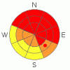
Deep slab avalanches are likely today in steep terrain that didn't recently avalanche. Last weekend, heavy and drifted new snow overloaded slopes plagued by existing weak sugary layers, and a very widespread natural hard slab avalanche cycle occurred across the Logan Forecast Zone. Yesterday's storm added significant weight to the fragile snowpack, likely enough to reactivate deeply buried weak layers on many slopes and at all elevations...
You could trigger a dangerous avalanche from a distance or from below. Triggered or natural deep hard slab avalanches could step down to weak snow near the ground and be very broad and destructive. Smaller storm snow or wind slab avalanches overrunning slopes with deeply buried weak snow could produce a much larger and more dangerous avalanche. |
|
|
THREAT #2 |

|
| WHERE |
PROBABILITY |
SIZE |
TREND |
|
|
|
|
| |
|
|
Over the next
36 hours.
|
|
|
Yesterday's storm caused a general upswing in avalanche danger and complexity, with significant wind slab and storm snow avalanches up to 2 feet deep now likely. Yesterday's somewhat light density snow was easily drifted into avalanche starting zones, even in areas only exposed to moderate winds.
The fresh snow likely preserved a nice layer of surface hoar or frost, which was widespread on shady slopes in the Central Bear River Range on Saturday. This weak layer is likely be sensitive to triggering today on many shady slopes. In other cases, it could be preserved and become another persistent weakness in our already complex snowpack... |
|
|
MOUNTAIN WEATHER |

|
Could see some snowfall continuing in the mountains this morning as the storm moves off to our east today. A short-lived high pressure system will begin to build into the region before a weak but moist storm arrives up north Wednesday afternoon, with accumulating snow likely into Thursday. |
|
|
GENERAL ANNOUNCEMENTS |
I will be issuing morning avalanche advisories for the Logan area on Mondays, Wednesdays, Fridays and Saturdays.
Consider purchasing some Beaver Mountain lift tickets here from our good friends at Backcountry.com in partnership with Ski Utah. All proceeds benefit the Friends of the Utah Avalanche Center.
If you want to get this avalanche advisory e-mailed to you daily click HERE.
Send us your avalanche and snow observations. You can also call me at 435-757-7578 or the SLC office at 800-662-4140, or email to uac@utahavalanchecenter.org
Donate to your favorite non-profit – The Friends of the Utah Avalanche Center. The UAC depends on contributions from users like you to support our work.
The information in this advisory is from the U.S. Forest Service, which is solely responsible for its content. This advisory describes general avalanche conditions and local variations always occur.
I will update this forecast Wednesday morning. Thanks for checking in.... |
|
|
This information does not apply to developed ski areas or highways where avalanche control is normally done. This advisory is from the U.S.D.A. Forest Service, which is solely responsible for its content. This advisory describes general avalanche conditions and local variations always occur. |
|
This advisory provided by the USDA Forest Service, in partnership with:
The Friends of the Utah Avalanche Center, Utah Division of State Parks and Recreation, Utah Division of Emergency Management, Salt Lake County, Salt Lake Unified Fire Authority and the friends of the La Sal Avalanche Center. See our Sponsors Page for a complete list. |
