SPECIAL ANNOUNCEMENT |
 |
A Special Avalanche Advisory continues for all the mountains of Utah today. Large avalanches can still be triggered by people on slopes approaching 35 degrees. These avalanches are responsible for two fatalities this week. A very persistent weak snowpack will remain unstable for some time to come. People should continue to avoid steep avalanche terrain this weekend. |
|
|
BOTTOM LINE
Danger by aspect and elevation on slopes approaching 35° or steeper.
(click HERE for tomorrow's danger rating)
|
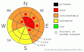
Danger Rose Tutorial
|
Very dangerous avalanche conditions continue in the backcountry around Logan. Overnight new snow, and more likely today will push the danger back up to HIGH (4) on upper elevation slopes that haven't recently avalanched, with significant deposits of new or especially wind drifted snow. On many other slopes in the region there is a CONSIDERABLE (3) danger, and you could trigger a deadly hard slab avalanche 2 to 5 feet deep or deeper and potentially quite wide in steep terrain with preexisting weak snow. You should avoid travel on or below such slopes, as recent avalanches in the region have been running far, many to the fullest extent of their paths. Smaller storm snow or wind slab avalanches overrunning slopes with deeply buried weak snow could produce a much larger and more dangerous avalanche. In these conditions you might trigger avalanches from a distance, or worse, from below.
Avoid travel on and under slopes approaching 35 degrees in steepness and obvious or historic avalanche paths in the backcountry. |
|
|
CURRENT CONDITIONS |

|
With 65 inches of total snow on the ground and 6 inches new snow to report from overnight, the Tony Grove Snotel now sits at 58% of normal water content for the date... It's 16 degrees at the 9700' Campbell Scientific weather station on Logan Peak, with a west southwest wind, currently averaging a bit over 15 mph... |
|
|
RECENT ACTIVITY |

|
Huge, long running natural hard slab avalanches from last weekend several feet deep are visible from the air across the Logan forecast zone, several half-a-mile wide or wider. Most activity occurred on northwest through east facing slopes, with a couple notable exceptions on southeast west facing slopes. I've posted some of our aerial observations from 1-28-10 here…
We noticed that riders triggered at least two more good sized avalanches Saturday in White Pine Canyon...From a distance, it looked like everyone stayed on to their sleds, but you might have a great story that I'd like to hear.
Here's an updated local backcountry avalanche list:
|
|
|
THREAT #1 |

|
| WHERE |
PROBABILITY |
SIZE |
TREND |
|
|
|
|
| |
|
|
Over the next
24 hours.
|
|
|
Last weekend, heavy and drifted new snow overloaded slopes plagued by existing weak sugary layers, and a very widespread natural hard slab avalanche cycle occurred across the Logan Forecast Zone. Today's storm might add enough weight to reactivate deeply buried weak layers in some areas.
Deep slab avalanches are still possible in steep upper and mid elevation terrain that didn't recently avalanche. Triggered deep or hard slab avalanches could step down to weak snow near the ground and be very broad and destructive. Smaller storm snow or wind slab avalanches overrunning slopes with deeply buried weak snow could produce a much larger and more dangerous avalanche, and you still might trigger a dangerous avalanche from a distance or below. |
|
|
THREAT #2 |

|
| WHERE |
PROBABILITY |
SIZE |
TREND |
|
|
|
|
| |
|
|
Over the next
36 hours.
|
|
|
Today's storm will cause a general upswing in avalanche danger and complexity, with wind slab and storm snow avalanches becoming more likely with continued accumulations and increasing or sustained winds. Light density snow is easily drifted into avalanche starting zones, even by moderate winds.
The light snow may preserve a nice layer of surface hoar or frost, which was widespread on shady slopes where we were in the Central Bear River Range yesterday. This weak layer may become active with today's additional snow, or it could be preserved, and become another persistent weakness in our already complex snowpack... |
|
|
MOUNTAIN WEATHER |

|
It's looking like today's will favor the Northern Wasatch and Bear River Ranges with a moist southwest flow and a pool of cold air moving through southeast Idaho... National Weather Service forecast calls for up to 10 additional inches of accumulation between this morning and tonight in the Bear River Range. |
|
|
GENERAL ANNOUNCEMENTS |
I will be issuing morning avalanche advisories for the Logan area on Mondays, Wednesdays, Fridays and Saturdays.
Consider purchasing some Beaver Mountain lift tickets here from our good friends at Backcountry.com in partnership with Ski Utah. All proceeds benefit the Friends of the Utah Avalanche Center.
If you want to get this avalanche advisory e-mailed to you daily click HERE.
Send us your avalanche and snow observations. You can also call me at 435-757-7578 or the SLC office at 800-662-4140, or email to uac@utahavalanchecenter.org
Donate to your favorite non-profit – The Friends of the Utah Avalanche Center. The UAC depends on contributions from users like you to support our work.
The information in this advisory is from the U.S. Forest Service, which is solely responsible for its content. This advisory describes general avalanche conditions and local variations always occur.
I will update this forecast Monday morning. Thanks for checking in.... |
|
|
This information does not apply to developed ski areas or highways where avalanche control is normally done. This advisory is from the U.S.D.A. Forest Service, which is solely responsible for its content. This advisory describes general avalanche conditions and local variations always occur. |
|
This advisory provided by the USDA Forest Service, in partnership with:
The Friends of the Utah Avalanche Center, Utah Division of State Parks and Recreation, Utah Division of Emergency Management, Salt Lake County, Salt Lake Unified Fire Authority and the friends of the La Sal Avalanche Center. See our Sponsors Page for a complete list. |
