AVALANCHE WARNING »
Dangerous avalanche conditions are occuring or are imminent.
Backcountry travel in avalanche terrain is not recommended.
|
 |
Notice: We've issued an AVALANCHE WARNING for all the mountains of Utah. Strong winds and heavy snow have created a HIGH avalanche danger on all aspects. Both natural and easily triggered avalanches are occurring at low..mid...and high elevations. People should avoid travel on and below all steep backcountry slopes and obvious or historic avalanche paths. Backcountry travel is not recommended |
|
|
BOTTOM LINE
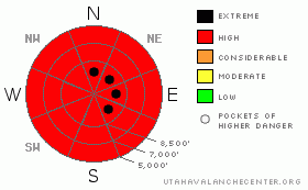
Danger by aspect and elevation on slopes approaching 35° or steeper.
(click HERE for tomorrow's danger rating)
|

Danger Rose Tutorial
|
Heavy snowfall and strong and sustained winds in the last several days have created very dangerous avalanche conditions in the backcountry. There is a HIGH (4) avalanche danger and you should not venture into avalanche terrain today.... Both natural and easily triggered avalanches 2 to 5 feet deep are likely on many slopes steeper than about 30 degrees in the region... We recommend that you avoid backcountry travel. |
|
|
CURRENT CONDITIONS |

|
The strongest yet in a productive series of Pacific storms slammed the Central Bear River Range with way too much heavy snow and sustained northwest winds yesterday, enough loading to put the fragile snowpack "over the edge" on many slopes...I urge that you stay clear of and out from under all steep slopes and obvious or historic avalanche paths today.
The Tony Grove Snotel reports about 18 inches of new snow from yesterday's blizzard, with 1.6 inches of water accumulation in the last 24 hours, and 2.5 inches of water in the last 48 hrs. With 78 inches of total snow on the ground, the station now sits at 59% of normal water content for the date.... |
|
|
RECENT ACTIVITY |

|
Much avalanche activity was reported to the Utah Avalanche Center in the last few days, with several people in the Utah backcountry caught and carried in scary avalanches. Friday, in the backcountry near Brighton Ski Area, a close call was reported, with the total burial of a skier who was recovered by his partner using a beacon.
More information posted here.
Locally; On Thursday In the north fork of Cottonwood Canyon, an experienced but fairly large party triggered two avalanches on adjacent north facing slopes at around 8000'....the third person up the skin track was caught and carried in the second avalanche, which broke 2 to 3 feet deep and around 40 feet above him while ascending skin track near the flank of the first avalanche...Saturday afternoon, a snowboarder remote triggered a scary avalanche in Beaver Canyon just above Logan Canyon Highway and a bit south of the parking pull-out used for Beaver backside runs...The dangerous avalanche on an east facing slope at around 6900' looked to be at least 2 feet deep....
2010 is so-far quite an active year for avalanches in the backcountry around Logan...Here's an updated local backcountry avalanche list:
|
|
|
THREAT #1 |

|
| WHERE |
PROBABILITY |
SIZE |
TREND |

|
|
|
|
| |
|
|
Over the next
24 hours.
|
|
|
Triggered and natural storm snow and wind slab avalanches are likely today at all elevations and on steep slopes facing all directions with significant deposits of new and especially wind drifted snow. |
|
|
THREAT #2 |

|
| WHERE |
PROBABILITY |
SIZE |
TREND |

|
|
|
|
| |
|
|
Over the next
24 hours.
|
|
|
Heavy and drifted new snow overloaded slopes plagued by existing weak sugary layers, and very dangerous persistent and deep slab avalanches are likely today... Deep hard slab avalanches could step down to weak snow near the ground and be very broad and destructive. Smaller avalanches overrunning slopes with a buried persistent weak layer could produce a much larger and more dangerous avalanche. In today's conditions, you are likely to trigger avalanches from a distance, or worse, from below. |
|
|
MOUNTAIN WEATHER |

|
Snow showers should taper off in the mountains today as a short-lived high pressure system builds over the region today...Light snow is possible tomorrow non-the-less, before the next splitting wave of Pacific storminess impacts the region on Tuesday. Despite the southerly track of the storm energy, widespread snow across the north is apparently possible. |
|
|
GENERAL ANNOUNCEMENTS |
I will be issuing morning avalanche advisories for the Logan area on Mondays, Wednesdays, Fridays and Saturdays.
Consider purchasing some Beaver Mountain lift tickets here from our good friends at Backcountry.com in partnership with Ski Utah. All proceeds benefit the Friends of the Utah Avalanche Center.
If you want to get this avalanche advisory e-mailed to you daily click HERE.
Send us your avalanche and snow observations. You can also call me at 435-757-7578 or the SLC office at 800-662-4140, or email to uac@utahavalanchecenter.org
Donate to your favorite non-profit – The Friends of the Utah Avalanche Center. The UAC depends on contributions from users like you to support our work.
The information in this advisory is from the U.S. Forest Service, which is solely responsible for its content. This advisory describes general avalanche conditions and local variations always occur.
I will update this forecast Monday morning. Thanks for checking in.... |
|
|
This information does not apply to developed ski areas or highways where avalanche control is normally done. This advisory is from the U.S.D.A. Forest Service, which is solely responsible for its content. This advisory describes general avalanche conditions and local variations always occur. |
|
This advisory provided by the USDA Forest Service, in partnership with:
The Friends of the Utah Avalanche Center, Utah Division of State Parks and Recreation, Utah Division of Emergency Management, Salt Lake County, Salt Lake Unified Fire Authority and the friends of the La Sal Avalanche Center. See our Sponsors Page for a complete list. |

