AVALANCHE WARNING »
Dangerous avalanche conditions are occuring or are imminent.
Backcountry travel in avalanche terrain is not recommended.
|
 |
Notice: We've issued an AVALANCHE WARNING for all the mountains of Utah. In the Logan Area, the avalanche danger will maintain its rise throughout the day and into the weekend as southwest winds increase and continue, temperatures stay warm, and more heavy snow accumulates on slopes with weak preexisting snow. |
|
|
BOTTOM LINE
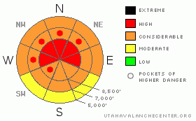
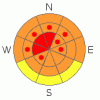
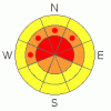
Danger by aspect and elevation on slopes approaching 35° or steeper.
(click HERE for tomorrow's danger rating)
|
Danger Rose Tutorial
|
Today, the danger will likely rise to HIGH (4) on drifted upper and mid-elevation slopes. Both natural and triggered wind and persistent slab avalanches are probable on many steep slopes in the region... You probably could trigger dangerous persistent or deep slab avalanches 2 to 4 feet deep on slopes steeper than about 35 degrees, especially on those with shallow and weak previous snow cover and with recent deposits of wind-drifted snow.
We recommend you avoid travel in avalanche terrain today, and certainly stay off of and out from under steep slopes and obvious or historic avalanche paths..... |
|
|
CURRENT CONDITIONS |

|
The wind sensor on Logan Peak recorded strong east winds for several hours overnight before they switched back from the south southwest. The Tony Grove Snotel reports 5/10ths of an inch of water accumulation in the last 24 hours, and with 50 inches of total snow on the ground, the station sits at 48% of normal water content for the date.... |
|
|
RECENT ACTIVITY |

|
Yesterday, much avalanche activity was reported to the Utah Avalanche Center, with at least three people in the backcountry caught and carried in scary avalanches. Luckily all survived and only one sustained serious injuries after being swept over a cliff. More information posted here.
Locally; In the north fork of Cottonwood Canyon, an experienced but fairly large party triggered two avalanches on adjacent north facing slopes at around 8000'....One person was caught and carried in second avalanche while ascending skin track on the flank of the first avalanche... I'll post more details on this near miss later today....
2010 is so-far quite an active year for avalanches in the backcountry around Logan...Here's an updated local backcountry avalanche list:
|
|
|
THREAT #1 |

|
| WHERE |
PROBABILITY |
SIZE |
TREND |
|
|
|
|
| |
|
|
Over the next
24 hours.
|
|
|
Triggered and natural wind slab avalanches will become increasingly likely today and into the weekend on steep slopes with significant deposits of drifted snow. The wind sensor on Logan Peak recorded a sustained period with strong east winds overnight... Current strong winds are out of the south and southwest as has been the case for the last few days. |
|
|
THREAT #2 |

|
| WHERE |
PROBABILITY |
SIZE |
TREND |
|
|
|
|
| |
|
|
Over the next
24 hours.
|
|
|
As heavy drifted snow overloads slopes plagued by existing weak sugary layers, very dangerous persistent and deep slab avalanches become more likely...In some areas, hard slab avalanches could step down to weak snow near the ground and be very broad and destructive. Smaller avalanches overrunning slopes with a buried weak layer could cause a much larger and more dangerous avalanche. In these conditions you might trigger avalanches from a distance, or worse, from below.... |
|
|
MOUNTAIN WEATHER |

|
The National Weather Service has issued a winter storm warning for the mountains around Logan through Sunday morning. We will pick up several more inches of accumulation with today's wave of storminess, and expect very strong and sustained southwest winds.…It looks like tomorrow will again be quite stormy in the mountains, with very strong southwest winds and significant snow accumulations possible. (9 to 19 inches forecast in our mountains by tomorrow night, with another 5-9 inches on Saturday night. ) |
|
|
GENERAL ANNOUNCEMENTS |
I will be issuing morning avalanche advisories for the Logan area on Mondays, Wednesdays, Fridays and Saturdays.
Consider purchasing some Beaver Mountain lift tickets here from our good friends at Backcountry.com in partnership with Ski Utah. All proceeds benefit the Friends of the Utah Avalanche Center.
If you want to get this avalanche advisory e-mailed to you daily click HERE.
Send us your avalanche and snow observations. You can also call me at 435-757-7578 or the SLC office at 800-662-4140, or email to uac@utahavalanchecenter.org
Donate to your favorite non-profit – The Friends of the Utah Avalanche Center. The UAC depends on contributions from users like you to support our work.
The information in this advisory is from the U.S. Forest Service, which is solely responsible for its content. This advisory describes general avalanche conditions and local variations always occur.
I will update this forecast Saturday morning. Thanks for checking in.... |
|
|
This information does not apply to developed ski areas or highways where avalanche control is normally done. This advisory is from the U.S.D.A. Forest Service, which is solely responsible for its content. This advisory describes general avalanche conditions and local variations always occur. |
|
This advisory provided by the USDA Forest Service, in partnership with:
The Friends of the Utah Avalanche Center, Utah Division of State Parks and Recreation, Utah Division of Emergency Management, Salt Lake County, Salt Lake Unified Fire Authority and the friends of the La Sal Avalanche Center. See our Sponsors Page for a complete list. |
