AVALANCHE WATCH »
The risk of an avalanche is expected to increase significantly
but the timing and location are still uncertain. Stay tuned for updates.
|
 |
Notice: We've issued an AVALANCHE WATCH for all the mountains of Utah. A very weak pre-existing snowpack along with recent snow and strong winds coupled with more expected snow is causing dangerous avalanche conditions in the backcountry. Steep avalanche terrain should be avoided over the next few days. |
|
|
BOTTOM LINE
Danger by aspect and elevation on slopes approaching 35° or steeper.
(click HERE for tomorrow's danger rating)
|
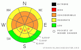
Danger Rose Tutorial
|
There is a CONSIDERABLE (3) danger on drifted upper and mid-elevation slopes, and you probably could trigger wind or persistent slab avalanches on many steep slopes in the region... Dangerous triggered deep slab avalanches 2 to 4 feet deep are also possible today on slopes steeper than about 35 degrees, especially on those with shallow and weak previous snow cover and with recent deposits of wind-drifted snow.
With intensifying south wind and periods of heavy snow in the forecast for the next couple days, I expect the danger will continue to rise and become more widespread as we head into the weekend... Evaluate the snow and terrain carefully, follow proper backcountry travel protocols, and continue use cautious route-finding and conservative tactics. |
|
|
CURRENT CONDITIONS |

|
Expect a windy and snowy day in the mountains, and the avalanche danger is on the rise....
The Tony Grove Snotel reports about 3 inches of new snow overnight and a storm total of 1.5 inches of water equivalent. There's now 47 inches of total snow on the ground, and 47% of normal water for the date. Its 16 degrees this morning at the Campbell Scientific weather station on Logan Peak at 9700', and after fairly strong southeast winds overnight, there's currently a 25 to 30 mph wind from the south. |
|
|
RECENT ACTIVITY |

|
No avalanches were reported locally yesterday, but it was fairly active in the rest of the Northern Utah Mountains, with numerous triggered and a few natural avalanches reported....Although I was viewing from a distance, I could see evidence of some natural activity on northeast facing slopes in the Mount Naomi Wilderness...Also, my party triggered a few audible collapses on both east and west facing slopes in the upper north fork of Cottonwood Canyon...
2010 is so-far quite an active year for avalanches in the backcountry around Logan...Here's an updated local backcountry avalanche list:
|
|
|
THREAT #1 |

|
| WHERE |
PROBABILITY |
SIZE |
TREND |

|
|
|
|
| |
|
|
Over the next
24 hours.
|
|
|
Tuesday's new snow bounded fairly well to the beat up old snow surface, (at least where we were in the Tony Grove Lake Area), but there are certainly areas in the forecast zone where this was not the case. We noted widespread surface hoar and near surface facets in sheltered lower elevation terrain, and weak snow developing above a rime-crust in some areas before the storm...As southwest winds increase and continue today, drifting the soft new snow into lee slope deposition areas, triggered wind slab or shallow persistent slab avalanches will become more likely on steep slopes. |
|
|
THREAT #2 |

|
| WHERE |
PROBABILITY |
SIZE |
TREND |

|
|
|
|
| |
|
|
Over the next
24 hours.
|
|
|
Very weak large grained faceted snow or depth hoar plagues the basal layers of the snowpack in many areas. On steep slopes which have already avalanched and on other slopes with generally shallow snow-cover there's a higher danger of triggering a dangerous hard slab avalanche. The new snow, especially when drifted onto one of these slopes may well be enough added weight to bring a slope close to the balance point, only needing a little additional weight or a trigger to avalanche...Here is where the dragon awaits... |
|
|
MOUNTAIN WEATHER |

|
Radar imagery shows heavy precipitation filling in and converging on the mountains around Logan, and we could pick up several more inches of accumulation with this morning's wave of storminess. South winds picked up again last night and are expected to intensify and remain strong today, tonight, and tomorrow…It looks like tomorrow will be quite stormy in the mountains, with very strong southwest winds and significant snow accumulations possible. (7 to 15 inches forecast for tomorrow and tomorrow night.) |
|
|
GENERAL ANNOUNCEMENTS |
I will be issuing morning avalanche advisories for the Logan area on Mondays, Wednesdays, Fridays and Saturdays.
Consider purchasing some Beaver Mountain lift tickets here from our good friends at Backcountry.com in partnership with Ski Utah. All proceeds benefit the Friends of the Utah Avalanche Center.
If you want to get this avalanche advisory e-mailed to you daily click HERE.
Send us your avalanche and snow observations. You can also call me at 435-757-7578 or the SLC office at 800-662-4140, or email to uac@utahavalanchecenter.org
Donate to your favorite non-profit – The Friends of the Utah Avalanche Center. The UAC depends on contributions from users like you to support our work.
The information in this advisory is from the U.S. Forest Service, which is solely responsible for its content. This advisory describes general avalanche conditions and local variations always occur.
I will update this forecast Friday morning. Thanks for checking in.... |
|
|
This information does not apply to developed ski areas or highways where avalanche control is normally done. This advisory is from the U.S.D.A. Forest Service, which is solely responsible for its content. This advisory describes general avalanche conditions and local variations always occur. |
|
This advisory provided by the USDA Forest Service, in partnership with:
The Friends of the Utah Avalanche Center, Utah Division of State Parks and Recreation, Utah Division of Emergency Management, Salt Lake County, Salt Lake Unified Fire Authority and the friends of the La Sal Avalanche Center. See our Sponsors Page for a complete list. |
