BOTTOM LINE
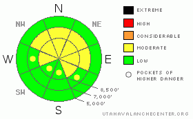
Danger by aspect and elevation on slopes approaching 35° or steeper.
(click HERE for tomorrow's danger rating)
|
Danger Rose Tutorial
|
The avalanche danger is MODERATE (2) in the backcountry around Logan, and the snow is generally very shallow and weak. Hard wind slab avalanches are possible on some steep drifted slopes, and although they are slowly getting harder to initiate, you could still trigger dangerous persistent slab avalanches 1 to 3 feet deep in some areas.... Both problems are most likely in drifted terrain above around 8000 feet in elevation and on north, northeast, and east facing slopes steeper than about 35 degrees. As new snow accumulates this week on the generally weak existing snowpack, the avalanche danger will most certainly rise...
Evaluate the snow and terrain carefully, follow proper backcountry travel protocols, and continue to use cautious route-finding and conservative tactics, especially on drifted upper elevation slopes. |
|
|
CURRENT CONDITIONS |

|
Appropriately for snow perhaps given the day, from the Reverend Martin Luther King: "We may have all come on different ships, but we're in the same boat now."
Across Utah and much of the Mountain West, weak sugary snow plagues generally shallow snow. Regardless of specific snow structures and great variability over areas, shallow snow-cover breeds weak snow, and weak snow we all have. The only question now revolves around the creation or the building of the inevitable slab, and this process could be beginning today with a series of moist Pacific storms lined up like rail-cars on a flexible track over Utah. Regardless of where we are or how we travel in the backcountry, we all face a serious rise in avalanche danger in the coming days....
Mountain temperatures dropped overnight and its now 18 degrees this morning at the Campbell Scientific weather station on Logan Peak at 9700', and there's currently a 25 to 30 mph wind from the southwest... The 8400' Tony Grove Snotel reports a temperature of 25 degrees, an inch of new snow early this morning, and 36 inches of total snow on the ground. The station sits at a dismal 43% of average water content for the date.... |
|
|
RECENT ACTIVITY |

|
No avalanches were reported locally since last weekend, but 2010 is so-far quite an active year for avalanches in the backcountry around Logan...
Here's an updated local backcountry avalanche list:
|
|
|
THREAT #1 |

|
| WHERE |
PROBABILITY |
SIZE |
TREND |

|
|
|
|
| |
|
|
Over the next
24 hours.
|
|
|
Recent winds drifted snow into shallow stiff slabs in lee slope and terrain governed deposition areas. Triggered wind slab avalanches are possible on steep slopes in exposed terrain.. As new snow begins to accumulate it'll be drifted into sensitive slabs by constant southwest winds.. |
|
|
THREAT #2 |

|
| WHERE |
PROBABILITY |
SIZE |
TREND |

|
|
|
|
| |
|
|
Over the next
24 hours.
|
|
|
Gradually becoming harder to initiate on most slopes, but triggered persistent slab avalanches 1 to 3 feet deep are still quite possible today on slopes steeper than about 35 degrees, especially on those at upper elevations with recent deposits of wind-drifted snow. Additional loading from this week's stormy weather may well be enough to reactivate deeply buried persistent weak layers..... |
|
|
MOUNTAIN WEATHER |

|
The first in a series of moist Pacific Storms will affect the area today, with the second, stronger round scheduled for this evening...Progressively moist waves of Pacific storminess will continue though the week affecting mainly the Southern Mountains, but significant accumulations are also probable up north in terrain favored by a southwest flow... |
|
|
GENERAL ANNOUNCEMENTS |
I will be issuing morning avalanche advisories for the Logan area on Mondays, Wednesdays, Fridays and Saturdays.
Consider purchasing some Beaver Mountain lift tickets here from our good friends at Backcountry.com in partnership with Ski Utah. All proceeds benefit the Friends of the Utah Avalanche Center.
If you want to get this avalanche advisory e-mailed to you daily click HERE.
Send us your avalanche and snow observations. You can also call me at 435-757-7578 or the SLC office at 800-662-4140, or email to uac@utahavalanchecenter.org
Donate to your favorite non-profit – The Friends of the Utah Avalanche Center. The UAC depends on contributions from users like you to support our work.
The information in this advisory is from the U.S. Forest Service, which is solely responsible for its content. This advisory describes general avalanche conditions and local variations always occur.
I will update this forecast Wednesday morning. Thanks for checking in.... |
|
|
This information does not apply to developed ski areas or highways where avalanche control is normally done. This advisory is from the U.S.D.A. Forest Service, which is solely responsible for its content. This advisory describes general avalanche conditions and local variations always occur. |
|
This advisory provided by the USDA Forest Service, in partnership with:
The Friends of the Utah Avalanche Center, Utah Division of State Parks and Recreation, Utah Division of Emergency Management, Salt Lake County, Salt Lake Unified Fire Authority and the friends of the La Sal Avalanche Center. See our Sponsors Page for a complete list. |
