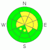
BOTTOM LINE
Danger by aspect and elevation on slopes approaching 35° or steeper.
(click HERE for tomorrow's danger rating)
|

Danger Rose Tutorial
|
The avalanche danger is MODERATE (2) in the backcountry around Logan, and the snowpack is very shallow and weak throughout on most slopes... Heightened avalanche conditions persist because you could still trigger a dangerous wind slab or persistent slab avalanche 1 to 3 feet deep in some areas.... Most likely in drifted terrain above around 8000 feet in elevation and on north, northeast, and east facing slopes steeper than about 35 degrees.
Evaluate the snow and terrain carefully, follow proper backcountry travel protocols, and continue to use cautious route-finding and conservative tactics, especially on drifted upper elevation slopes.. |
|
|
CURRENT CONDITIONS |

|
Not many people out in the backcountry , and although surface wind, sun, and rain crusts are widespread across most regional slopes, we've found cleaner air and reasonable and fast turning conditions in sheltered terrain... And, we’ve been riding on mostly supportable snow in some upper elevation areas. But the snow off-trail is generally very shallow, droppy, and still a bit spooky in most areas....
It’s 17 degrees this morning at the Campbell Scientific weather station on Logan Peak at 9700', and there's currently a 20 from the northwest... At 6:00 this morning, the 8400' Tony Grove Snotel reports 20 degrees and 38 inches of total snow on the ground. The station sits at a dismal 44% of average water content for the date.... |
|
|
RECENT ACTIVITY |

|
No avalanches were reported locally since last weekend, but 2010 is so-far quite an active year for avalanches in the backcountry around Logan
Here's an updated local backcountry avalanche list:
|
|
|
THREAT #1 |

|
| WHERE |
PROBABILITY |
SIZE |
TREND |
|
|
|
|
| |
|
|
Over the next
24 hours.
|
|
|
Recent winds drifted snow into shallow stiff slabs in lee slope and terrain governed deposition areas. Triggered wind slab avalanches are possible on steep slopes in exposed terrain.. |
|
|
THREAT #2 |

|
| WHERE |
PROBABILITY |
SIZE |
TREND |
|
|
|
|
| |
|
|
Over the next
24 hours.
|
|
|
Very weak larger grained faceted snow and depth hoar plague the shallow snowpack on many slopes and at upper elevations, a dangerous, apparently very persistent weakness involves large faceted grains (depth hoar) elevated several inches above the ground on a solid October ice-crust.
Triggered persistent slab avalanches 1 to 3 feet deep are still quite possible today on slopes steeper than about 35 degrees, especially on those at upper elevations with recent deposits of wind-drifted snow. |
|
|
MOUNTAIN WEATHER |

|
Expect fair weather conditions today with mountain high temperatures around freezing and moderate southwest winds, as the smoggy inversion rebuilds in Cache Valley for the weekend. We're all looking hopefully toward the early part of next week for a definitive pattern change, which will likely bring significant Pacific moisture into the region, though favoring the south.....With this, accumulating snowfall in the Northern Mountains is likely on Monday and Tuesday and again later on in the week... |
|
|
GENERAL ANNOUNCEMENTS |
I will be issuing morning avalanche advisories for the Logan area on Mondays, Wednesdays, Fridays and Saturdays.
Consider purchasing some Beaver Mountain lift tickets here from our good friends at Backcountry.com in partnership with Ski Utah. All proceeds benefit the Friends of the Utah Avalanche Center.
If you want to get this avalanche advisory e-mailed to you daily click HERE.
Send us your avalanche and snow observations. You can also call me at 435-757-7578 or the SLC office at 800-662-4140, or email to uac@utahavalanchecenter.org
Donate to your favorite non-profit – The Friends of the Utah Avalanche Center. The UAC depends on contributions from users like you to support our work.
The information in this advisory is from the U.S. Forest Service, which is solely responsible for its content. This advisory describes general avalanche conditions and local variations always occur.
I will update this forecast Saturday morning. Thanks for checking in.... |
|
|
This information does not apply to developed ski areas or highways where avalanche control is normally done. This advisory is from the U.S.D.A. Forest Service, which is solely responsible for its content. This advisory describes general avalanche conditions and local variations always occur. |
|
This advisory provided by the USDA Forest Service, in partnership with:
The Friends of the Utah Avalanche Center, Utah Division of State Parks and Recreation, Utah Division of Emergency Management, Salt Lake County, Salt Lake Unified Fire Authority and the friends of the La Sal Avalanche Center. See our Sponsors Page for a complete list. |
