BOTTOM LINE
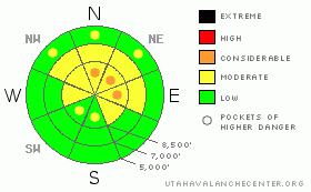
Danger by aspect and elevation on slopes approaching 35° or steeper.
(click HERE for tomorrow's danger rating)
|
Danger Rose Tutorial
|
Overall the avalanche danger is MODERATE (2) in the backcountry around Logan, and the snowpack is very shallow and weak throughout on most slopes...Pockets with a CONSIDERABLE(3) danger remain in steep drifted terrain at upper elevations. Heightened avalanche conditions persist because triggered fresh wind slab and dangerous persistent slab avalanches 1 to 3 feet deep are possible in some areas.... These are most likely above around 8000 feet in elevation on north, northeast and east facing slopes steeper than about 35 degrees.
Evaluate the snow and terrain carefully and continue to use cautious route-finding and conservative tactics, especially on drifted upper elevation slopes.. |
|
|
CURRENT CONDITIONS |

|
It’s 24 degrees this morning at the Campbell Scientific weather station on Logan Peak at 9700', and there's currently a 20 to 30 mph wind from the southwest... At 6:00 this morning, the 8400' Tony Grove Snotel reports 28 degrees and 38 inches of total snow on the ground. The station sits at a dismal 45% of average water content for the date....
There is wide variety in the snow across the zone, and the snowpack is showing good signs of stabilization in many areas. But, recent avalanche activity and poor snow structure at higher elevations in the Central and Northern Bear River Range dictate caution…Although surface wind, sun, and rain crusts are widespread across most regional slopes, we've found cleaner air and reasonable and fast turning conditions in sheltered terrain... And riding on mostly supportable, although generally very shallow and still somewhat spooky snow in most upper elevation areas.... |
|
|
RECENT ACTIVITY |

|
No avalanches were reported locally since last weekend, but 2010 is so far quite an active year for avalanches in the backcountry around Logan
Here's an updated local backcountry avalanche list:
If you have a new and exciting avalanche story, we'd love to hear it.... Or if you see avalanche activity that I miss in this big country, please shoot us an email uac@utahavalanchecenter.org or call me directly at (435)-757-7578 ....The information you provide may well save lives.
|
|
|
THREAT #1 |

|
| WHERE |
PROBABILITY |
SIZE |
TREND |

|
|
|
|
| |
|
|
Over the next
24 hours.
|
|
|
Somewhat strong and sustained southwest winds yesterday and overnight picked up and drifted some snow into shallow stiff drifts on lee slopes and in terrain governed deposition zones. Triggered wind slab avalanches are possible on steep slopes in exposed terrain... Drifting will likely continue today, and more than expected accumulation will likely cause a rise in this threat. |
|
|
THREAT #2 |

|
| WHERE |
PROBABILITY |
SIZE |
TREND |
|
|
|
|
| |
|
|
Over the next
24 hours.
|
|
|
Many recent avalanches involved small faceted snow crystals that were weakened on the snow surface during the late December high pressure system. Similar conditions are now weakening the shallow snow. Very weak larger grained faceted snow and depth hoar plague the shallow snowpack on many slopes, and a dangerous apparently very persistent weakness involves large faceted grains (depth hoar) elevated several inches above the ground on a solid October ice-crust. Triggered persistent slab avalanches 1 to 3 feet deep are still possible today on slopes steeper than about 35 degrees, especially on those at upper elevations with deposits of freshly wind-drifted snow. |
|
|
MOUNTAIN WEATHER |

|
Looks like we'll probably see a bit of snow in the mountains today, but not much....National Weather Service forecasters call for less than 1/2 inch of accumulation today and another light inch overnight tonight if we're lucky....At least the smog should be partially blown out of the Cache Valley and we might get a breath or two of fresher air before the high pressure and inversion return in full force for the weekend.
Expect cloudy conditions with mountain high temperatures around freezing and moderate south to southeast winds today.... We're hopefully looking toward the early or middle part of next week for a pattern change , which will likely bring Pacific moisture into the region, though favoring the south..... |
|
|
GENERAL ANNOUNCEMENTS |
I will be issuing morning avalanche advisories for the Logan area on Mondays, Wednesdays, Fridays and Saturdays.
Consider purchasing some Beaver Mountain lift tickets here from our good friends at Backcountry.com in partnership with Ski Utah. All proceeds benefit the Friends of the Utah Avalanche Center.
If you want to get this avalanche advisory e-mailed to you daily click HERE.
Send us your avalanche and snow observations. You can also call me at 435-757-7578 or the SLC office at 800-662-4140, or email to uac@utahavalanchecenter.org
Donate to your favorite non-profit – The Friends of the Utah Avalanche Center. The UAC depends on contributions from users like you to support our work.
The information in this advisory is from the U.S. Forest Service, which is solely responsible for its content. This advisory describes general avalanche conditions and local variations always occur.
I will update this forecast Friday morning. Thanks for checking in.... |
|
|
This information does not apply to developed ski areas or highways where avalanche control is normally done. This advisory is from the U.S.D.A. Forest Service, which is solely responsible for its content. This advisory describes general avalanche conditions and local variations always occur. |
|
This advisory provided by the USDA Forest Service, in partnership with:
The Friends of the Utah Avalanche Center, Utah Division of State Parks and Recreation, Utah Division of Emergency Management, Salt Lake County, Salt Lake Unified Fire Authority and the friends of the La Sal Avalanche Center. See our Sponsors Page for a complete list. |
