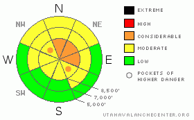
BOTTOM LINE
Danger by aspect and elevation on slopes approaching 35° or steeper.
(click HERE for tomorrow's danger rating)
|
Danger Rose Tutorial
|
There is MODERATE avalanche danger on most steep slopes in the backcountry around Logan, but a CONSIDERABLE danger remains in steep drifted terrain at upper elevations. Heightened avalanche conditions exist because dangerous triggered persistent or deep slab avalanches 1 to 3 feet deep are possible in many areas.... These are most likely above around 8000 feet in elevation on north through southeast facing slopes steeper than about 35 degrees.
Continue to use careful snowpack evaluation, cautious route finding, and conservative decision-making in avalanche terrain today.... |
|
|
CURRENT CONDITIONS |

|
There is wide variety in the snow across the zone, and the snowpack is showing good signs of stabilization in many areas. But, recent avalanche activity and poor snow structure at higher elevations in the Central and Northern Bear River Range dictate caution…. The now somewhat stiff snow in the upper levels of the snow mostly supports the weight of even a 4-stroke sled, and you can ride almost anywhere you dare. It appears that shallowly buried rocks and lingering dangerous avalanche conditions are keeping most folks off of the steep upper elevation hills and many slopes remain untracked so far this season……
Its 35 degrees at the Campbell Scientific weather station on Logan Peak at 9700', and there's a light breeze from the north-northeast... At 6:00 this morning, the 8400' Tony Grove Snotel reports 38 inches of total snow on the ground, and the station sits at a dismal 47% of average water content for the date.... |
|
|
RECENT ACTIVITY |

|
We hope to hear more about a scary near miss Friday (1-8-10) in the Northern Bear River Mountains near Bloomington Lake ID...Luckily everyone is OK after four sledders triggered and were "involved in" a large avalanche... A couple sledders also triggered a nice hard slab avalanche up in the Tony Grove Area on Friday...It was on a fairly small, sunny hill, especially compared to the surrounding terrain, but it was a fairly big and dangerous avalanche non-the-less. I posted Jeremy's report here
Looking across Franklin Basin yesterday from Beaver Mountain, I noticed a few fresh looking and broad avalanches in the upper Hell's Kitchen Canyon, which must have occurred late last week or over the weekend...
Here's an updated local backcountry avalanche list:
If you have a new and exciting avalanche story we'd love to hear it.... Or if you see avalanche activity that I miss in this big country. Please shoot us an email uac@utahavalanchecenter.org or call me at (435)-757-7578 ....The information you provide may save lives.
|
|
|
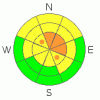
THREAT #1 |

|
| WHERE |
PROBABILITY |
SIZE |
TREND |
|
|
|
|
| |
|
|
Over the next
24 hours.
|
|
|
Most of last week's avalanches involved small faceted snow crystals that were weakened on the snow surface during the late December high pressure system... Triggered persistent slab avalanches 1 to 3 feet deep are still possible today on slopes steeper than about 35 degrees, especially on those at upper elevations with deposits of heavy, wind-drifted snow. |
|
|
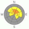
THREAT #2 |

|
| WHERE |
PROBABILITY |
SIZE |
TREND |
|
|
|
|
| |
|
|
Over the next
24 hours.
|
|
|
Very weak larger grained faceted snow and depth hoar plagues the deep snowpack on many slopes...Some of last week's avalanches failed on the basal layer of the snow, (or the ground)....Another dangerous weakness involves large faceted grains (depth hoar) elevated several inches above the ground on a solid October ice-crust. Smaller avalanches overrunning slopes with deeply buried weak layers could produce much larger deep slab avalanches...
Because of the very presence of persistent weak faceted snow and a propagating slab,today you still might trigger a large avalanche remotely, or worse, from below. |
|
|
MOUNTAIN WEATHER |

|
A strong high pressure system set up over the region for the early part of the week will keep the smog trapped in the valley while warm temperatures and sunshine continue to burn-out the shallow snow cover on sunny slopes...
Our nearest hope for relief comes on Wednesday, with a chance for a little snow in the mountains...But the weak storm is likely to split before reaching Northern Utah, with the southern energy, in the form of a cutoff low, heading south and affecting mainly southwest desert regions..... |
|
|
GENERAL ANNOUNCEMENTS |
I will be issuing morning avalanche advisories for the Logan area on Mondays, Wednesdays, Fridays and Saturdays.
Consider purchasing some Beaver Mountain lift tickets here from our good friends at Backcountry.com in partnership with Ski Utah. All proceeds benefit the Friends of the Utah Avalanche Center.
If you want to get this avalanche advisory e-mailed to you daily click HERE.
Send us your avalanche and snow observations. You can also call me at 435-757-7578 or the SLC office at 800-662-4140, or email to uac@utahavalanchecenter.org
Donate to your favorite non-profit – The Friends of the Utah Avalanche Center. The UAC depends on contributions from users like you to support our work.
The information in this advisory is from the U.S. Forest Service, which is solely responsible for its content. This advisory describes general avalanche conditions and local variations always occur.
I will update this forecast Wednesday morning. Thanks for checking in.... |
|
|
This information does not apply to developed ski areas or highways where avalanche control is normally done. This advisory is from the U.S.D.A. Forest Service, which is solely responsible for its content. This advisory describes general avalanche conditions and local variations always occur. |
|
This advisory provided by the USDA Forest Service, in partnership with:
The Friends of the Utah Avalanche Center, Utah Division of State Parks and Recreation, Utah Division of Emergency Management, Salt Lake County, Salt Lake Unified Fire Authority and the friends of the La Sal Avalanche Center. See our Sponsors Page for a complete list. |
