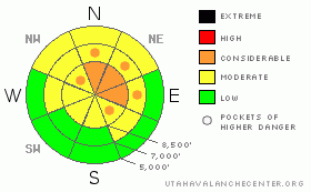
BOTTOM LINE
Danger by aspect and elevation on slopes approaching 35° or steeper.
(click HERE for tomorrow's danger rating)
|
Danger Rose Tutorial
|
This weekend, a CONSIDERABLE danger remains in steep drifted upper elevation terrain, and there is MODERATE danger on most other steep snow covered slopes in the backcountry around Logan. Dangerous triggered persistent or deep slab avalanches 1 to 3 feet deep are possible in many areas, and most likely above around 8000 feet in elevation on north and east facing slopes steeper than about 35 degrees.
Use careful snowpack evaluation, cautious route finding, and conservative decision-making in avalanche terrain today....
. |
|
|
CURRENT CONDITIONS |

|
Wednesday's wind, freezing rain, and upper elevation rime made conditions fairly supportable, but also gave us a rather inconsistent snow surface. Yesterday, we found the most enjoyable fast snow on south facing slopes and in sheltered pockets. The now somewhat stiff snow in the upper levels of the snowpack now mostly supports the weight of even a 4-stroke sled, and you can ride almost anywhere you dare. It appears that shallowly buried rocks and lingering dangerous avalanche conditions are keeping most folks off of the steep upper elevation hills and many slopes remain untracked so far this season……
With a temperature of 27 degrees at 6:00 this morning, the 8400' Tony Grove Snotel reports 39 inches of total snow on the ground, and the station is now up to a dismal 48% of average water content for the date. Its 23 degrees at the Campbell Scientific weather station on Logan Peak at 9700', and after posting 25 mph hourly averages for a couple hours from west overnight, the winds shifted from the north this morning and diminished into the teens.... |
|
|
RECENT ACTIVITY |

|
Last weekend was active in the Logan Area, with a number of fairly large triggered avalanches, and luckily no injuries...Here's an updated local backcountry avalanche list:
My party and I intentionally triggered a fairly large avalanche Wednesday (1-6-10) off the Crescent Lake-Steep Hollow Ridge with a very small cornice drop. The avalanche was a bit bigger and a bit more sensitive than I'd anticipated. I posted the report here…
Reports are trickling in about a scary near miss Friday (1-8-10) in the Northern Bear River Mountains near Bloomington Lake ID...Luckily everyone is OK after four sledders triggered and were "involved in" a large avalanche... A couple sledders also triggered a nice hard slab avalanche up in the Tony Grove Area on Friday...It was on a fairly small, sunny hill, especially compared to the surrounding terrain, but it was a fairly big and dangerous avalanche non-the-less. I posted Jeremy's report here
|
|
|
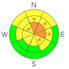
THREAT #1 |

|
| WHERE |
PROBABILITY |
SIZE |
TREND |
|
|
|
|
| |
|
|
Over the next
24 hours.
|
|
|
Most of last week's avalanches involved small faceted snow crystals that were weakened on the snow surface during the late December high pressure system... Triggered persistent slab avalanches 1 to 3 feet deep are still possible today on slopes steeper than about 35 degrees, especially on those at upper elevations with recent deposits of heavy, wind-drifted snow. |
|
|
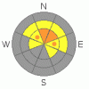
THREAT #2 |

|
| WHERE |
PROBABILITY |
SIZE |
TREND |
|
|
|
|
| |
|
|
Over the next
24 hours.
|
|
|
Very weak larger grained faceted snow and depth hoar plagues the deep snowpack on many slopes...Some of last week's avalanches failed on the basal layer or on a solid October ice crust several inches above the ground...Today you still might trigger a large avalanche remotely, or worse, from below. Smaller avalanches overrunning slopes with deeply buried weak layers could produce much larger deep slab avalanches... |
|
|
MOUNTAIN WEATHER |

|
Expect mostly cloudy and warm conditions in the mountains today, with a small chance for a little snowfall. A fairly strong high pressure system will reestablish itself over the region for the first part of next week...Looking like a midweek storm is likely to split up, but there's still a chance for a bit of accumulation in our area.... |
|
|
GENERAL ANNOUNCEMENTS |
I will be issuing morning avalanche advisories for the Logan area on Mondays, Wednesdays, Fridays and Saturdays.
Consider purchasing some Beaver Mountain lift tickets here from our good friends at Backcountry.com in partnership with Ski Utah. All proceeds benefit the Friends of the Utah Avalanche Center.
If you want to get this avalanche advisory e-mailed to you daily click HERE.
Send us your avalanche and snow observations. You can also call me at 435-757-7578 or the SLC office at 800-662-4140, or email to uac@utahavalanchecenter.org
Donate to your favorite non-profit – The Friends of the Utah Avalanche Center. The UAC depends on contributions from users like you to support our work.
The information in this advisory is from the U.S. Forest Service, which is solely responsible for its content. This advisory describes general avalanche conditions and local variations always occur.
I will update this forecast Monday morning. Thanks for checking in.... |
|
|
This information does not apply to developed ski areas or highways where avalanche control is normally done. This advisory is from the U.S.D.A. Forest Service, which is solely responsible for its content. This advisory describes general avalanche conditions and local variations always occur. |
|
This advisory provided by the USDA Forest Service, in partnership with:
The Friends of the Utah Avalanche Center, Utah Division of State Parks and Recreation, Utah Division of Emergency Management, Salt Lake County, Salt Lake Unified Fire Authority and the friends of the La Sal Avalanche Center. See our Sponsors Page for a complete list. |
