SPECIAL ANNOUNCEMENT |
 |
We've issued a Special Avalanche Advisory for the Logan Area Mountains...There is a HIGH avalanche danger in the backcountry, and dangerous avalanches remain likely on drifted upper elevation slopes....
You should avoid travel in steep upper elevation terrain today. |
|
|
BOTTOM LINE
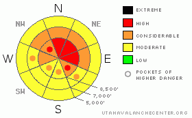
Danger by aspect and elevation on slopes approaching 35° or steeper.
(click HERE for tomorrow's danger rating)
|
Danger Rose Tutorial
|
Even with improving weather in the mountains, there is a HIGH avalanche danger on upper elevation slopes facing northwest through southeast with recent deposits of heavy wind-drifted snow....Dangerous persistent slab avalanches 2 to 3 feet deep are likely above around 8000 feet in elevation on slopes steeper than about 35 degrees. There is a CONSIDERABLE danger and dangerous avalanche conditions exist as well on many other steep slopes in the region... Today you could trigger avalanches remotely from a distance, or worse from below. Smaller avalanches overrunning slopes with deeply buried weak layers could produce much larger deep slab avalanches...
I urge everyone to stay clear of and out from under steep drifted slopes and avoid obvious or historic avalanche paths..... |
|
|
CURRENT CONDITIONS |

|
We encountered wind-driven sleet and freezing rain in Franklin Basin Yesterday, and snow conditions deteriorated to downright "coastal" by afternoon.... With a temperature of 11 degrees at 5:00 this morning, the 8400' Tony Grove Snotel reports a few inches of new snow and 8/10ths of an inch of water accumulation in the last 48 hours. There is 42 inches of total snow on the ground and with the help of a moist New Years storm, the station is now up to 50% of average water content for the date. Its 6 degrees at the Campbell Scientific weather station on Logan Peak at 9700', and the wind sensor appears rimed again....northeast flow and possible canyon winds expected
I found it easy to bog down in the heavy New Years snow when I rode off the beaten path on the flats in upper Steep Hollow. My track dug down into the weak December snow underneath, and I found myself digging with a shovel, all the way to the ground a couple times to get the sled turned and unstuck....Under the stiff slab from the New Years storm, the snow was loose and granular, small grained like sugar, and near the ground a bit larger grained like sea salt. |
|
|
RECENT ACTIVITY |

|
It was a very active New Years weekend locally, with many significant natural avalanches region-wide and 7 or 8 large triggered avalanches in the backcountry...
Saturday, snowmobilers remotely triggered a couple good sized avalanches from an adjacent slope in Providence Canyon near the warming hut under Providence Peak. The near miss occurred on a relatively small slope compared to many in the popular hill-climbing area, (1-2-10 avalanche report) ....And two different parties of skiers report triggering avalanches, one above the Tony Grove Campground and a couple remotely in Holiday Bowl in upper Blind Hollow
On Sunday the 1-3-10 backcountry travelers triggered a couple more dangerous avalanches....One up in Steep Hollow and one in Miller Bowl, just south of Tony Grove Lake.....
I intentionally triggered a fairly large avalanche yesterday (1-6-10) off the Crescent Lake-Steep Hollow Ridge with a very small cornice drop. I posted the report here…
|
|
|
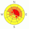
THREAT #1 |

|
| WHERE |
PROBABILITY |
SIZE |
TREND |
|
|
|
|
| |
|
|
Over the next
24 hours.
|
|
|
Yesterday's strong and sustained northwest winds drifted heavy snow and sleet into lee slope avalanche starting zones... The additional load was apparently enough on many slopes to reactivate persistent weak layers... Easily triggered persistent slab avalanches up to 3 feet deep are likely again today on slopes steeper than about 35 degrees with recent deposits of heavy or wind-drifted snow..... |
|
|
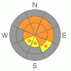
THREAT #2 |

|
| WHERE |
PROBABILITY |
SIZE |
TREND |
|
|
|
|
| |
|
|
Over the next
24 hours.
|
|
|
Yesterday, wind drifting and lee slope loading overloaded slopes with weak snow structure. Fresh wind slabs are likely to create dangerous avalanches stepping down into older weak layers. |
|
|
MOUNTAIN WEATHER |

|
Expect mostly fair weather conditions in the mountains today with mountain high temperatures approaching 20 degrees around midday before dropping back down into the single digits tonight...It will also be mostly clear tomorrow before a weak system makes its way into the region for the weekend, bringing a chance for a bit of light snow. Then the high pressure will build overhead early next week....Our next chance for a more significant storm system comes around the middle of next week |
|
|
GENERAL ANNOUNCEMENTS |
I will be issuing morning avalanche advisories for the Logan area on Mondays, Wednesdays, Fridays and Saturdays.
Consider purchasing some Beaver Mountain lift tickets here from our good friends at Backcountry.com in partnership with Ski Utah. All proceeds benefit the Friends of the Utah Avalanche Center.
If you want to get this avalanche advisory e-mailed to you daily click HERE.
Send us your avalanche and snow observations. You can also call me at 435-757-7578 or the SLC office at 800-662-4140, or email to uac@utahavalanchecenter.org
Donate to your favorite non-profit – The Friends of the Utah Avalanche Center. The UAC depends on contributions from users like you to support our work.
The information in this advisory is from the U.S. Forest Service, which is solely responsible for its content. This advisory describes general avalanche conditions and local variations always occur.
I will update this forecast Friday morning. Thanks for checking in.... |
|
|
This information does not apply to developed ski areas or highways where avalanche control is normally done. This advisory is from the U.S.D.A. Forest Service, which is solely responsible for its content. This advisory describes general avalanche conditions and local variations always occur. |
|
This advisory provided by the USDA Forest Service, in partnership with:
The Friends of the Utah Avalanche Center, Utah Division of State Parks and Recreation, Utah Division of Emergency Management, Salt Lake County, Salt Lake Unified Fire Authority and the friends of the La Sal Avalanche Center. See our Sponsors Page for a complete list. |
