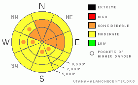
BOTTOM LINE
Danger by aspect and elevation on slopes approaching 35° or steeper.
(click HERE for tomorrow's danger rating)
|
Danger Rose Tutorial
|
There is a CONSIDERABLE avalanche danger in the backcountry around Logan, and dangerous avalanche conditions exist on upper and mid elevation slopes plagued by notoriously persistent buried weak layers. There are also pockets with a considerable danger of fresh wind slab avalanches on steep slopes exposed to wind drifting....Triggered persistent slabs and very dangerous deep hard slab avalanches remain likely on slopes steeper than about 35 degrees, mainly on northwest through east facing slopes above about 8000' in elevation. In these areas, you could trigger avalanches remotely from a distance, or worse from below. Smaller avalanches overrunning slopes with deeply buried weak layers could produce much larger deep slab avalanches...
Careful snowpack evaluation, cautious route-finding, and conservative decision-making are essential for safe travel in the backcountry today. |
|
|
CURRENT CONDITIONS |

|
With a temperature of 27 degrees at 6:00 this morning, the 8400' Tony Grove Snotel reports a few inches of new snow and 4/10ths of an inch of water in the last 24 hours. There is 40 inches of total snow on the ground and with the help of a moist New Years storm, the station is now up to 49% of average water content for the date. Moderate NW winds are reported and its 22 degrees at the Campbell Scientific weather station on Logan Peak (9700').
Expect the few inches of new snow to have been drifted around a lot by overnight winds...The New Year brought warmer and much denser wind driven and rimed snow, which now sits as a hefty slab atop a shallow weak base...In many places, if you step off your sled or take off your skis, you sink straight to the ground...Trying to walk anywhere in boots is a horrendous wallow..... |
|
|
RECENT ACTIVITY |

|
It was a very active New Years weekend locally, with many significant natural avalanches region-wide and 7 or 8 large triggered avalanches in the backcountry...
Saturday, snowmobilers remotely triggered a couple good sized avalanches from an adjacent slope in Providence Canyon near the warming hut under Providence Peak. The near miss occurred on a relatively small slope compared to many in the popular hill-climbing area, (1-2-10 avalanche report) ....And two different parties of skiers report triggering avalanches, one above the Tony Grove Campground and a couple remotely in Holiday Bowl in upper Blind Hollow
On Sunday the 1-3-10 backcountry travelers triggered a couple more dangerous avalanches....One up in Steep Hollow and one in Miller Bowl, just south of Tony Grove Lake.....
|
|
|
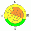
THREAT #1 |

|
| WHERE |
PROBABILITY |
SIZE |
TREND |
|
|
|
|
| |
|
|
Over the next
24 hours.
|
|
|
New, denser snow accumulations over the New Years Holiday created a cohesive slab on a variety of weak old snow surfaces from December’s sustained high pressure and preserved by last Wednesday's cold powder. There are also other, more deeply buried faceted weak layers, with deep mid-pack facets on upper elevation shady slopes and basal layer depth hoar at mid-elevations and in shallower areas. Triggered persistent slab avalanches are probable today on slopes steeper than about 35 degrees with significant recent deposits of heavy or wind-drifted snow.....
The New Years snow load may well be enough to reactivate what is now a deep weak layer in some areas. The weak layer of concern consists of very weak and notoriously persistent faceted snow. Many slopes afflicted with an unstable snow structure only now have received enough of a load to avalanche.... The deep hard slabs possible today could be quite broad and might be triggered from a distance, or in a much worse scenario, from below... |
|
|
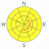
THREAT #2 |

|
| WHERE |
PROBABILITY |
SIZE |
TREND |
|
|
|
|
| |
|
|
Over the next
24 hours.
|
|
|
Pockets of Considerable danger exist in upper elevation terrain exposed to wind drifting... |
|
|
MOUNTAIN WEATHER |

|
Temperatures will continue an upward trend until around noon and then drop back down into the single digits this afternoon, and it will be cold in the mountains tonight....Fairly strong northwest winds should diminish throughout the day today and we'll probably pick up another inch or two of accumulation up high. A high pressure system will build into the region for the last part of the week, with fair and sunny weather forecast for the mountains... |
|
|
GENERAL ANNOUNCEMENTS |
I will be issuing morning avalanche advisories for the Logan area on Mondays, Wednesdays, Fridays and Saturdays.
Consider purchasing some Beaver Mountain lift tickets here from our good friends at Backcountry.com in partnership with Ski Utah. All proceeds benefit the Friends of the Utah Avalanche Center.
If you want to get this avalanche advisory e-mailed to you daily click HERE.
Send us your avalanche and snow observations. You can also call me at 435-757-7578 or the SLC office at 800-662-4140, or email to uac@utahavalanchecenter.org
Donate to your favorite non-profit – The Friends of the Utah Avalanche Center. The UAC depends on contributions from users like you to support our work.
The information in this advisory is from the U.S. Forest Service, which is solely responsible for its content. This advisory describes general avalanche conditions and local variations always occur.
I will update this forecast Friday morning. Thanks for checking in.... |
|
|
This information does not apply to developed ski areas or highways where avalanche control is normally done. This advisory is from the U.S.D.A. Forest Service, which is solely responsible for its content. This advisory describes general avalanche conditions and local variations always occur. |
|
This advisory provided by the USDA Forest Service, in partnership with:
The Friends of the Utah Avalanche Center, Utah Division of State Parks and Recreation, Utah Division of Emergency Management, Salt Lake County, Salt Lake Unified Fire Authority and the friends of the La Sal Avalanche Center. See our Sponsors Page for a complete list. |
