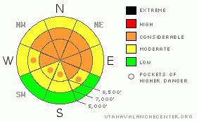
BOTTOM LINE
Danger by aspect and elevation on slopes approaching 35° or steeper.
(click HERE for tomorrow's danger rating)
|
Danger Rose Tutorial
|
There is a CONSIDERABLE avalanche danger in the backcountry around Logan, and dangerous avalanche conditions exist on upper and mid elevation slopes plagued by notoriously persistent buried weak layers. Triggered persistent slabs and very dangerous deep hard slab avalanches remain likely on slopes steeper than about 35 degrees. You could trigger avalanches remotely from a distance, or worse from below. Smaller avalanches overrunning slopes with deeply buried weak layers could produce much larger deep slab avalanches...
Careful snowpack evaluation, cautious route-finding, and conservative decision-making are essential for safe travel in the backcountry today.
|
|
|
CURRENT CONDITIONS |

|
With a temperature of 20 degrees at 6:00 this morning, the 8400' Tony Grove Snotel reports 40 inches of total snow on the ground and with the help of a moist New Years storm, the station is now up to 47% of average water content for the date. I'm thinking fairly light winds this morning and its 15 degrees at the Campbell Scientific weather station on Logan Peak, where the wind sensor appears rimed.....
The New Year brought warmer and much denser wind driven and rimed snow, which now sits as a hefty slab atop a shallow weak base...In many places, if you step off your sled or take off your skis, you sink straight to the ground...Trying to walk anywhere in boots is a horrendous wallow..... |
|
|
RECENT ACTIVITY |

|
On Friday a party in the Southern Bear River Range remotely triggered a wide hard slab avalanche on a southeast facing slope off an exposed ridge at a bit over 8000' in elevation...The 1'-3' deep avalanche reported was about as wide as a football field...I posted the report here
Saturday, snowmobilers remotely triggered a couple good sized avalanches from an adjacent slope in Providence Canyon near the warming hut under Providence Peak. The near miss occurred on a relatively small slope compared to many in the popular hill-climbing area, which remain mostly untracked.. (1-2-10 avalanche report)
Its been a week since we visited a very wide avalanche on Cornice Ridge. The 2'-6' deep by 1/4 mile? wide Christmas Holiday avalanche involved nearly the entire cirque.......The avalanche report is here. |
|
|
THREAT #1 |

|
| WHERE |
PROBABILITY |
SIZE |
TREND |

|
|
|
|
| |
|
|
Over the next
24 hours.
|
|
|
New, denser snow accumulations over the New Years Holiday created a cohesive slab on a variety of weak old snow surfaces from December’s sustained high pressure and preserved by last Wednesday's cold powder. Triggered persistent slab avalanches are probable today on slopes steeper than about 35 degrees with significant recent deposits of heavy or wind-drifted snow..... |
|
|
THREAT #2 |

|
| WHERE |
PROBABILITY |
SIZE |
TREND |
|
|
|
|
| |
|
|
Over the next
24 hours.
|
|
|
The New Years snow load may well be enough to reactivate what is now a deep weak layer in some areas. The weak layer of concern consists of very weak and notoriously persistent faceted snow. Many slopes afflicted with an unstable snow structure only now have received enough of a load to avalanche.... The deep hard slabs possible today could be quite broad and might be triggered from a distance, or in a much worse scenario, from below... |
|
|
MOUNTAIN WEATHER |

|
Under mostly sunny skies, mountain temperatures will approach 30 degrees today...With a high pressure in place overhead and warming aloft, the conditions are ripe for dense overnight fog in Cache Valley....A weak system will begin to affect our region tomorrow, with increasing clouds and a chance for a bit of snow for the mid-section of the week. The high pressure should build in again around Thursday. |
|
|
GENERAL ANNOUNCEMENTS |
I will be issuing morning avalanche advisories for the Logan area on Mondays, Wednesdays, Fridays and Saturdays.
Consider purchasing some Beaver Mountain lift tickets here from our good friends at Backcountry.com in partnership with Ski Utah. All proceeds benefit the Friends of the Utah Avalanche Center.
If you want to get this avalanche advisory e-mailed to you daily click HERE.
Send us your avalanche and snow observations. You can also call me at 435-757-7578 or the SLC office at 800-662-4140, or email to uac@utahavalanchecenter.org
Donate to your favorite non-profit – The Friends of the Utah Avalanche Center. The UAC depends on contributions from users like you to support our work.
The information in this advisory is from the U.S. Forest Service, which is solely responsible for its content. This advisory describes general avalanche conditions and local variations always occur.
I will update this forecast Wednesday morning. Thanks for checking in.... |
|
|
This information does not apply to developed ski areas or highways where avalanche control is normally done. This advisory is from the U.S.D.A. Forest Service, which is solely responsible for its content. This advisory describes general avalanche conditions and local variations always occur. |
|
This advisory provided by the USDA Forest Service, in partnership with:
The Friends of the Utah Avalanche Center, Utah Division of State Parks and Recreation, Utah Division of Emergency Management, Salt Lake County, Salt Lake Unified Fire Authority and the friends of the La Sal Avalanche Center. See our Sponsors Page for a complete list. |
