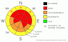
BOTTOM LINE
Danger by aspect and elevation on slopes approaching 35° or steeper.
(click HERE for tomorrow's danger rating)
|
Danger Rose Tutorial
|
There is a HIGH avalanche danger in the mountains around Logan. Dangerous avalanche conditions exist on upper and mid elevation slopes plagued by notoriously persistent buried weak layers. Triggered wind slab and storm snow avalanches are likely on slopes steeper than about 30 degrees, and natural avalanches are possible in steeper terrain. The danger of very dangerous, deep hard slab avalanches also increased with yesterday's new loading. Smaller storm snow or wind slab avalanches overrunning slopes with deeply buried weak layers could produce much larger avalanches...
We should avoid travel in avalanche terrain today and stay clear of the run-out zones of obvious or historic avalanche paths.... |
|
|
CURRENT CONDITIONS |

|
Looks like another stormy day in the mountains, and the National Weather Service has continued a Winter Storm Warning. through this afternoon. Yesterday's wind, warmth, and heavier snow created dangerous avalanche conditions in the backcountry for the weekend...
Southwest winds picked up significantly on New Years Eve, with 45 mph sustained hourly averages out of the west-southwest reported by the Campbell Scientific weather station on Logan Peak.
With a temperature of 25 degrees at 5:00 this morning, the Tony Grove Snotel reports 42 inches of total snow on the ground with 8/10ths of an inch of water accumulation in the last 24 hrs and 1.5 inches in the last 48 hours. |
|
|
RECENT ACTIVITY |

|
Saturday, snowmobilers remotely triggered a couple good sized avalanches from an adjacent slope in Providence Canyon near the warming hut under Providence Peak. The near miss occurred on a relatively small slope compared to many in the popular hill-climbing area, which remain mostly untracked.. (1-2-10 report)
On Friday a party in the Southern Bear River Range remotely triggered a wide hard slab avalanche on a southeast facing slope off an exposed ridge at a bit over 8000' in elevation...The 1'-3' deep avalanche reported was about as wide as a football field...I posted the report here
Its been about a week since a very wide avalanche occurred on Cornice Ridge over the Christmas Holiday. The 2'-6' deep by 1/4 mile? wide avalanche involved nearly the entire cirque....... I posted the avalanche report here. |
|
|
THREAT #1 |

|
| WHERE |
PROBABILITY |
SIZE |
TREND |
|
|
|
|
| |
|
|
Over the next
24 hours.
|
|
|
New, denser accumulations created a cohesive slab on a variety of weak old snow surfaces from December’s sustained high pressure and preserved by Wednesday's cold powder. Triggered wind slab and storm snow avalanches are probable today on steep slopes at all elevations on slopes steeper than about 30 degrees with significant deposits of new or wind-drifted snow. |
|
|
THREAT #2 |

|
| WHERE |
PROBABILITY |
SIZE |
TREND |
|
|
|
|
| |
|
|
Over the next
24 hours.
|
|
|
The new snow load may well be enough to reactivate what is now a deep weak layer in some areas. The weak layer consists of very weak and notoriously persistent faceted snow. Many slopes afflicted with an unstable snow structure only now have received enough of a load to avalanche.... Today’s deep hard slabs are capable of being quite broad and they could be triggered from a distance, or in a much worse scenario, from below... In exposed upper elevation terrain, the problem with the deeply buried weak snow will certainly be exacerbated the rebuilding and added weight on the thickening slab by recent wind drifting and rapidly accumulating snow.....
drifting observations 12-30-09 |
|
|
MOUNTAIN WEATHER |

|
Although the storm is mostly winding down, we're likely to see another good burst of storminess before its all said and done, with a few more inches of accumulation likely today....A dirty ridge will build into the region for the first part of next week, but small storms are likely to bring only the very Top of Utah a bit more weather in that time frame... |
|
|
GENERAL ANNOUNCEMENTS |
I will be issuing morning avalanche advisories for the Logan area on Mondays, Wednesdays, Fridays and Saturdays.
Consider purchasing some Beaver Mountain lift tickets here from our good friends at Backcountry.com in partnership with Ski Utah. All proceeds benefit the Friends of the Utah Avalanche Center.
If you want to get this avalanche advisory e-mailed to you daily click HERE.
Send us your avalanche and snow observations. You can also call me at 435-757-7578 or the SLC office at 800-662-4140, or email to uac@utahavalanchecenter.org
Donate to your favorite non-profit – The Friends of the Utah Avalanche Center. The UAC depends on contributions from users like you to support our work.
The information in this advisory is from the U.S. Forest Service, which is solely responsible for its content. This advisory describes general avalanche conditions and local variations always occur.
I will update this forecast Monday morning. Thanks for checking in.... |
|
|
This information does not apply to developed ski areas or highways where avalanche control is normally done. This advisory is from the U.S.D.A. Forest Service, which is solely responsible for its content. This advisory describes general avalanche conditions and local variations always occur. |
|
This advisory provided by the USDA Forest Service, in partnership with:
The Friends of the Utah Avalanche Center, Utah Division of State Parks and Recreation, Utah Division of Emergency Management, Salt Lake County, Salt Lake Unified Fire Authority and the friends of the La Sal Avalanche Center. See our Sponsors Page for a complete list. |
