AVALANCHE WATCH »
The risk of an avalanche is expected to increase significantly
but the timing and location are still uncertain. Stay tuned for updates.
|
 |
Notice: Warming temperatures, wind, and additional heavy snowfall on slopes with existing buried weak layers have the potential to increase the avalanche danger to HIGH in the backcountry this weekend. |
|
|
BOTTOM LINE
Danger by aspect and elevation on slopes approaching 35° or steeper.
(click HERE for tomorrow's danger rating)
|
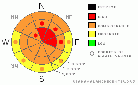
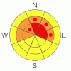
Danger Rose Tutorial
|
Warming temperatures, continued strong westerly winds, and increasingly heavy snowfall will cause a CONSIDERABLE avalanche danger in the backcountry. The danger will rise during the day today and overnight with an intensifying winter storm. Rapid accumulation rates of warmer heavier snow and continuing west winds could cause storm snow and fresh wind slab avalanches to become likely at all elevations. Upper elevation slopes facing north and east are plagued by a notoriously persistent buried weak layer, and the danger of very large hard slab avalanches will increase with today's new loading. The dangerous and destructive nature of these potential deep slab avalanches warrants the addition of a HIGH danger on these slopes.... Smaller storm snow or wind slab avalanches overloading slopes with deeply buried weak layers could produce much larger avalanches.... Large natural avalanches are possible today and overnight in some areas that did not avalanche last year....
To begin the New Year, we should avoid travel on or under steep slopes and obvious or historic avalanche paths.... |
|
|
CURRENT CONDITIONS |

|
Yesterday was so last year, and in this New Year, 2010, you'll find completely different snow conditions than you did yesterday and in 2009. Overnight weather likely changed the benign Utah 4% fluff from yesterday into the classic and dangerous cohesive slab... Increasing temperatures, intensifying winds, and continuing periods of rapid snow accumulations will conspire to cause a rise in backcountry avalanche danger today and into the first weekend….
Looks like another stormy day in the mountains, and the National Weather Service has issued a Winter Storm Warning. Southwest winds picked up significantly last night, with 45 mph sustained hourly averages out of the west-southwest reported by the Campbell Scientific weather station on Logan Peak. As of 5:00 this morning, the Tony Grove Snotel reports 40 inches of total snow on the ground with a half inch of water accumulation in the last 6 hrs and 1.2 inches in the last 48 hours.
|
|
|
RECENT ACTIVITY |

|
Its been quiet avalanche-wise in the mountains around Logan, with most people staying in low angle terrain and rocky conditions keeping riders off most big upper elevation hills. The fresh light and cold powder of the last couple days did not contain enough weight to overload weak surface or deeply buried layers, which are all over the place... Its been about a week since a very wide avalanche occurred on Cornice Ridge over the Christmas Holiday. The 2'-6' deep by 1/4 mile? wide avalanche involved nearly the entire cirque. I posted the avalanche report here. |
|
|
THREAT #1 |

|
| WHERE |
PROBABILITY |
SIZE |
TREND |

|
|
|
|
| |
|
|
Over the next
24 hours.
|
|
|
The danger will rise during the day today...... Expect warming temperatures, continued strong westerly winds, and increasingly heavy snowfall, with the cold front and the brunt of the energy not scheduled until tomorrow morning…New denser accumulations will create a cohesive slab on a variety of weak old snow surfaces from December’s sustained high pressure and preserved by Wednesday's cold powder. Wind slab and storm snow avalanches may become likely on steep slopes at all elevations with significant deposits of new or wind-drifted snow.
|
|
|
THREAT #2 |

|
| WHERE |
PROBABILITY |
SIZE |
TREND |
|
|
|
|
| |
|
|
Over the next
24 hours.
|
|
|
..Today's new load may well be enough to reactivate what is now a deep weak layer in some areas.. The weak layer consists of very weak and notoriously persistent faceted snow....Many slopes afflicted with an unstable snow structure are only now receiving enough of a load.... These deep hard slabs are capable of being quite broad... In exposed upper elevation terrain, the problem will certainly be worsened by wind drifting and rapidly accumulating snow.....
drifting observations 12-20-09 |
|
|
MOUNTAIN WEATHER |

|
Expect continued snowfall and windy conditions as moisture increases ahead of a strong wave scheduled to arrive early tomorrow. 8500' temperatures are expected to be in the mid twenties, with warmer temperatures and rain possible at the lowest elevations.. We could see a bit of a letup in the storm later this afternoon, but storminess will resume overnight tonight and last well into tomorrow…Winds should shift around from the north tomorrow and a high pressure system will build into the region for the first part of next week. |
|
|
GENERAL ANNOUNCEMENTS |
I will be issuing morning avalanche advisories for the Logan area on Mondays, Wednesdays, Fridays and Saturdays.
Consider purchasing some Beaver Mountain lift tickets here from our good friends at Backcountry.com in partnership with Ski Utah. All proceeds benefit the Friends of the Utah Avalanche Center.
If you want to get this avalanche advisory e-mailed to you daily click HERE.
Send us your avalanche and snow observations. You can also call me at 435-757-7578 or the SLC office at 800-662-4140, or email to uac@utahavalanchecenter.org
Donate to your favorite non-profit – The Friends of the Utah Avalanche Center. The UAC depends on contributions from users like you to support our work.
The information in this advisory is from the U.S. Forest Service, which is solely responsible for its content. This advisory describes general avalanche conditions and local variations always occur.
I will update this forecast tomorrow morning. Thanks for checking in.... |
|
|
This information does not apply to developed ski areas or highways where avalanche control is normally done. This advisory is from the U.S.D.A. Forest Service, which is solely responsible for its content. This advisory describes general avalanche conditions and local variations always occur. |
|
This advisory provided by the USDA Forest Service, in partnership with:
The Friends of the Utah Avalanche Center, Utah Division of State Parks and Recreation, Utah Division of Emergency Management, Salt Lake County, Salt Lake Unified Fire Authority and the friends of the La Sal Avalanche Center. See our Sponsors Page for a complete list. |
