SPECIAL ANNOUNCEMENT |
 |
THIS SPECIAL AVALANCHE ADVISORY IS FOR ALL THE MOUNTAINS OF NORTHERN AND CENTRAL UTAH. HEAVY SNOWFALL AND WIND WILL OVERLOAD A VERY FRAGILE AND WEAK SNOWPACK...RAPIDLY CREATING DANGEROUS AVALANCHE CONDITIONS. THOSE WITHOUT EXPERT AVALANCHE TRAINING AND BACKCOUNTRY SKILLS SHOULD AVOID TRAVEL IN AVALANCHE TERRAIN......... |
|
|
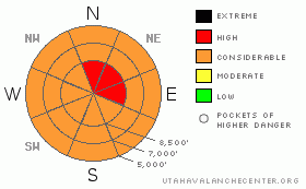
BOTTOM LINE
Danger by aspect and elevation on slopes approaching 35° or steeper.
(click HERE for tomorrow's danger rating)
|
Danger Rose Tutorial
|
With heavy snowfall and increasing northwest winds, the overall avalanche danger will rise to CONSIDERABLE during the day today in the Backcountry. Rapid accumulation rates on weak existing surface snow and increasing winds will cause storm snow and fresh wind slab avalanches to become likely. Upper elevation slopes facing north and east are plagued by a very persistent buried weak layer, and the danger of very large triggered hard slab avalanches will increase with today's new loading. The dangerous and destructive nature of these potential deep slab avalanches warrants a HIGH danger rating on these slopes.... Large natural avalanches are possible later this afternoon and overnight in some areas....
We should avoid travel on or under steep slopes and obvious or historic avalanche paths.... |
|
|
CURRENT CONDITIONS |

|
Looks like a stormy day in the mountains, and the National Weather Service has issued a Winter Storm Warning. Southwest winds are already picking up this morning, as are snowfall rates in the mountains...The USU Doc Daniel Snotel reports 3 inches of new snow overnight. Its 10 degrees at 9700' at the CSI weather station on Logan Peak, currently with a 25 mph southwest wind. Its 15 degrees up at the Tony Grove Snotel, and the station reports shallow snow cover, with 29 inches of total snow on the ground, containing only 38% of average water for the date.
Expect periods of heavy snowfall today in the mountains, with winds shifting around from the west and northwest.... |
|
|
RECENT ACTIVITY |

|
I went up to Cornice Ridge to have a look at a very wide avalanche from over the Christmas Holiday. The 2'-6' deep by 1/4 mile? wide avalanche involved nearly the entire cirque. I posted the avalanche report here. |
|
|
THREAT #1 |

|
| WHERE |
PROBABILITY |
SIZE |
TREND |

|
|
|
|
| |
|
|
Over the next
36 hours.
|
|
|
Very weak faceted snow underlying the mid-December slab is slow to heal, and there are still places where the snowpack is still unstable enough for you to trigger dangerous hard slab avalanches....Today's new load may reactivate this deep weak layer in some areas.. By the looks of the recent Cornice Ridge avalanche, these deep hard slabs are capable of being quite broad... In exposed upper elevation terrain, the problem will certainly be worsened by wind drifting and rapidly accumulating snow..... |
|
|
THREAT #2 |

|
| WHERE |
PROBABILITY |
SIZE |
TREND |

|
|
|
|
| |
|
|
Over the next
24 hours.
|
|
|
The danger will rise drastically during the day today.......Increasingly heavy snowfall will fall on a variety of weak snow surfaces, and wind slab and storm snow avalanches will become likely on steep slopes at all elevations with significant deposits of new or wind drifted snow. |
|
|
GENERAL ANNOUNCEMENTS |
I will be issuing morning avalanche advisories for the Logan area on Mondays, Wednesdays, Fridays and Saturdays.
Consider purchasing some Beaver Mountain lift tickets here from our good friends at Backcountry.com in partnership with Ski Utah. All proceeds benefit the Friends of the Utah Avalanche Center.
If you want to get this avalanche advisory e-mailed to you daily click HERE.
Send us your avalanche and snow observations. You can also call me at 435-757-7578 or the SLC office at 800-662-4140, or email to uac@utahavalanchecenter.org
Donate to your favorite non-profit – The Friends of the Utah Avalanche Center. The UAC depends on contributions from users like you to support our work.
The information in this advisory is from the U.S. Forest Service, which is solely responsible for its content. This advisory describes general avalanche conditions and local variations always occur.
I will update this forecast on Friday morning. Thanks for checking in.... |
|
|
This information does not apply to developed ski areas or highways where avalanche control is normally done. This advisory is from the U.S.D.A. Forest Service, which is solely responsible for its content. This advisory describes general avalanche conditions and local variations always occur. |
|
This advisory provided by the USDA Forest Service, in partnership with:
The Friends of the Utah Avalanche Center, Utah Division of State Parks and Recreation, Utah Division of Emergency Management, Salt Lake County, Salt Lake Unified Fire Authority and the friends of the La Sal Avalanche Center. See our Sponsors Page for a complete list. |
