SPECIAL ANNOUNCEMENT |
 |
Consider purchasing some Beaver Mountain lift tickets here from our good friends at Backcountry.com in partnership with Ski Utah. All proceeds benefit the Friends of the Utah Avalanche Center. |
|
|
BOTTOM LINE
Danger by aspect and elevation on slopes approaching 35° or steeper.
(click HERE for tomorrow's danger rating)
|
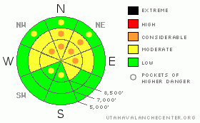
Danger Rose Tutorial
|
Overall, there is a MODERATE (2) danger in the Logan Area Backcountry, and dangerous triggered avalanches are still possible on many steep upper elevation slopes... Although the likelihood is gradually decreasing with time as the snow on most slopes slowly stabilizes, the deadly nature of potential hard slab avalanches lingering on shady upper elevation slopes with weak preexisting snow warrants the inclusion of pockets with a CONSIDERABLE (3) danger. In these areas, you might trigger dangerous persistent slab avalanches on slopes steeper than about 35 degrees.
Evaluate the snow and terrain carefully, giving utmost respect to steep upper elevation slopes facing north through east. |
|
|
CURRENT CONDITIONS |

|
It’s not shaping up to be a good year from the snow and avalanche perspective. Shallow snow cover allows persistent weak layers to form and to remain weak or get weaker, while keeping us off of them for fear of hitting rocks....Many normally popular slopes in the region remain untouched, and fear of lingering avalanche danger will keep me from being the first to put my tracks on anything steep and adequately covered that hasn't yet avalanched…..
Looks like a nice day in the mountains, a little warmer than yesterday, mostly sunny with temperatures in the mid twenties. Its 12 degrees at 9700' at the CSI weather station on Logan Peak, with a 20 mph south-southwest wind. Its 15 degrees up at the Tony Grove Snotel, and the station reports a sad 30 inches of total snow on the ground, containing only 39% of average water for the date. |
|
|
RECENT ACTIVITY |

|
An observer viewed evidence of a large Hard Slab avalanche up on Cornice Ridge over the weekend. Judging only from the location of the avalanche, one might assume that this was human triggered, (hopefully from the ridge) but many details are unknown at this point... I posted the observation here. |
|
|
THREAT #1 |

|
| WHERE |
PROBABILITY |
SIZE |
TREND |
|
|
|
|
| |
|
|
Over the next
36 hours.
|
|
|
Very weak faceted snow underlying the mid-December slab is slow to heal, and there are still places where the snowpack is still unstable enough for you to trigger dangerous hard slab avalanches....This is a tricky and sometimes very scary time when hard slab avalanches may be somewhat difficult to trigger, but can also be dangerous and destructive. By the looks of the recent Cornice Ridge avalanche, the current 2-3' deep hard slabs are capable of being quite broad... In exposed upper elevation terrain, the problem may have been worsened by holiday wind drifting |
|
|
MOUNTAIN WEATHER |

|
Should be a nice day in the mountains with temperatures in the mid-twenties and a light southwest wind. Expect light snow to develop tomorrow and continue tomorrow night under a light southwest flow. A slightly stronger impulse with a bit more snow to follow on Wednesday.... |
|
|
GENERAL ANNOUNCEMENTS |
I will be issuing morning avalanche advisories for the Logan area on Mondays, Wednesdays, Fridays and Saturdays.
Discount Lift tickets: Ski Utah, Backcountry.com, Alta, Deer Valley, Park City, The Canyons, Wolf Mountain, Snowbasin, Beaver Mountain, Brighton, Sundance, and Solitude have donated a limited number of tickets for sale at discounted prices.
If you want to get this avalanche advisory e-mailed to you daily click HERE.
Send us your avalanche and snow observations. You can also call me at 435-757-7578 or the SLC office at 800-662-4140, or email to uac@utahavalanchecenter.org
Donate to your favorite non-profit – The Friends of the Utah Avalanche Center. The UAC depends on contributions from users like you to support our work.
The information in this advisory is from the U.S. Forest Service, which is solely responsible for its content. This advisory describes general avalanche conditions and local variations always occur.
I will update this forecast on Wednesday morning. Thanks for checking in.... |
|
|
This information does not apply to developed ski areas or highways where avalanche control is normally done. This advisory is from the U.S.D.A. Forest Service, which is solely responsible for its content. This advisory describes general avalanche conditions and local variations always occur. |
|
This advisory provided by the USDA Forest Service, in partnership with:
The Friends of the Utah Avalanche Center, Utah Division of State Parks and Recreation, Utah Division of Emergency Management, Salt Lake County, Salt Lake Unified Fire Authority and the friends of the La Sal Avalanche Center. See our Sponsors Page for a complete list. |
