SPECIAL ANNOUNCEMENT |
 |
Consider purchasing some Beaver Mountain lift tickets here from our good friends at Backcountry.com in partnership with Ski Utah. All proceeds benefit the Friends of the Utah Avalanche Center. |
|
|
BOTTOM LINE
Danger by aspect and elevation on slopes approaching 35° or steeper.
(click HERE for tomorrow's danger rating)
|
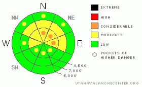
Danger Rose Tutorial
|
Overall, there is a MODERATE (2) danger in the Logan Area Backcountry, and dangerous triggered avalanches are possible on many steep upper elevation slopes...
Although the likelihood is gradually decreasing with time as the snow on most slopes slowly stabilizes, the deadly nature of potential hard slab avalanches lingering on shady upper elevation slopes with weak preexisting snow warrants the inclusion of pockets with a CONSIDERABLE (3) danger. In these areas, you might trigger dangerous persistent slab avalanches on slopes steeper than about 35 degrees. You also might encounter shallow wind slab avalanches in exposed upper elevation terrain.
Evaluate the snow and terrain carefully this weekend, giving utmost respect to steep upper elevation slopes facing north through east. |
|
|
CURRENT CONDITIONS |

|
Don't want to damage the nice new Christmas presents on all the rocks out there. Most folks haven’t yet put away the rock skis, and local pre-Christmas Ptex sales-rates were astronomical. I'm told there still just isn't enough coverage for hill-climbing, and I certainly don't want to risk damaging the nice new 4-stroke sled on a rock. Shallow snow cover is protecting many untracked areas from us, and numerous hills in the Logan Area remain untouched, the perilous snowpack untested.
Looks like another cold day in the mountains, only a little warmer than yesterday with cloud cover and a chance for a bit of snow this morning…Its a cool 11 degrees at 9700' at the CSI weather station on Logan Peak, with a 20 mph northeast wind. Its 12 degrees up at the Tony Grove Snotel, and it looks like we may have picked up an inch or so overnight. The station reports a meager 31 inches of total snow on the ground, containing 42% of average water for the date. |
|
|
RECENT ACTIVITY |

|
No new triggered avalanches were reported in the Logan Area for over a week now. But, a few sizable triggered avalanches (or pockets) were reported mid-week in the Central Wasatch. These were not giant avalanches, but hard slabs ranging from 50 to 80 feet wide and 2 feet deep are dangerous and often deadly.
A week before Christmas my party remotely triggered a fairly large avalanche in the Tony Grove Area. (Tony Grove-Blind Hollow Saddle,12-18-09) |
|
|
THREAT #1 |

|
| WHERE |
PROBABILITY |
SIZE |
TREND |
|
|
|
|
| |
|
|
Over the next
36 hours.
|
|
|
Very weak faceted snow underlying the mid-December slab is slow to heal, and there are still places where the snowpack is still probably unstable enough for you to trigger dangerous hard slab avalanches....This is a tricky and sometimes scary time when hard slab avalanches may be somewhat difficult to trigger, but can also be dangerous and destructive. |
|
|
THREAT #2 |

|
| WHERE |
PROBABILITY |
SIZE |
TREND |
|
|
|
|
| |
|
|
Over the next
24 hours.
|
|
|
Expect the danger of fresh wind slab avalanches to diminish a bit over the weekend, but you still might find some shallow sensitive wind slabs today built by yesterday's northwest and/or this morning's moderate northeast winds. |
|
|
MOUNTAIN WEATHER |

|
A high pressure system will control the weather through the weekend, but moisture lingering in the atmosphere will allow for clouds and perhaps a bit of light snow in the mountains. Moisture will increase early next week in a disorganized and weak westerly flow, with our next chance for a significant accumulation around the middle of the week. It doesn't look like a big event by any means, but at least the weather pattern should keep the inversion from building up... |
|
|
GENERAL ANNOUNCEMENTS |
I will be issuing morning avalanche advisories for the Logan area on Mondays, Wednesdays, Fridays and Saturdays.
Discount Lift tickets: Ski Utah, Backcountry.com, Alta, Deer Valley, Park City, The Canyons, Wolf Mountain, Snowbasin, Beaver Mountain, Brighton, Sundance, and Solitude have donated a limited number of tickets for sale at discounted prices.
If you want to get this avalanche advisory e-mailed to you daily click HERE.
Send us your avalanche and snow observations. You can also call me at 435-757-7578 or the SLC office at 800-662-4140, or email to uac@utahavalanchecenter.org
Donate to your favorite non-profit – The Friends of the Utah Avalanche Center. The UAC depends on contributions from users like you to support our work.
The information in this advisory is from the U.S. Forest Service, which is solely responsible for its content. This advisory describes general avalanche conditions and local variations always occur.
I will update this forecast on Monday morning. Thanks for checking in.... |
|
|
This information does not apply to developed ski areas or highways where avalanche control is normally done. This advisory is from the U.S.D.A. Forest Service, which is solely responsible for its content. This advisory describes general avalanche conditions and local variations always occur. |
|
This advisory provided by the USDA Forest Service, in partnership with:
The Friends of the Utah Avalanche Center, Utah Division of State Parks and Recreation, Utah Division of Emergency Management, Salt Lake County, Salt Lake Unified Fire Authority and the friends of the La Sal Avalanche Center. See our Sponsors Page for a complete list. |
