SPECIAL ANNOUNCEMENT |
 |
Need a stocking stuffer?
Consider purchasing some Beaver Mountain lift tickets here from our good friends at Backcountry.com in partnership with Ski Utah. All proceeds benefit the Friends of the Utah Avalanche Center. |
|
|
BOTTOM LINE
Danger by aspect and elevation on slopes approaching 35° or steeper.
(click HERE for tomorrow's danger rating)
|
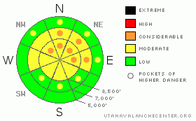
Danger Rose Tutorial
|
There is a MODERATE (2) danger on most upper elevation slopes in the Logan Area backcountry, and triggered avalanches are possible.. Dangerous avalanche conditions persist on steep slopes that did not yet avalanche, and pockets with a CONSIDERABLE (3) danger remain on shady slopes above around 7500' in elevation with weak preexisting snow. In these areas, you probably could trigger dangerous avalanches on slopes steeper than about 35 degrees. In some cases, avalanches could still be triggered remotely from a distance, or from below. Increasing north winds this afternoon will cause a heightened danger of fresh wind slab avalanches in exposed terrain.
Careful snowpack evaluation, cautious route-finding, and conservative decision-making are essential for safe backcountry travel today. |
|
|
CURRENT CONDITIONS |

|
There are 2 inches of new snow from yesterday and its 22 degrees at the 8400' Tony Grove Snotel, and with 30 inches of total snow on the ground the station sits at 48% of average snow for the date. The Campbell Scientific weather station at 9700’on Logan Peak reports 10 mph winds from the north and 15 degrees this morning.
|
|
|
RECENT ACTIVITY |

|
My party remotely triggered a large avalanche Friday afternoon while returning back down to the sled in the Tony Grove Area. (Tony Grove-Blind Hollow Saddle,12-18-09)
Seems you could still trigger dangerous slab avalanches on this classic persistent weak layer, and a party yesterday reported more collapsing and cracking up in the Bunch Grass Area (12-22-09) |
|
|
THREAT #1 |

|
| WHERE |
PROBABILITY |
SIZE |
TREND |
|
|
|
|
| |
|
|
Over the next
36 hours.
|
|
|
Very weak faceted snow plagues most shady upper and mid elevation slopes, and slabs built on top of this junk by the significant heavy snow last weekend caused a very unstable snow structure.... This turns out to be a persistent and very dangerous problem, and a great danger of triggering deadly avalanches remains on slopes that haven't already avalanched... As we've seen last week, in these conditions, avalanches can be triggered remotely from a distance, or worse from below. |
|
|
THREAT #2 |

|
| WHERE |
PROBABILITY |
SIZE |
TREND |

|
|
|
|
| |
|
|
Over the next
18 hours.
|
|
|
Expect the danger of fresh wind slab avalanches to rise with strong north winds in the forecast for later this afternoon and tonight... |
|
|
MOUNTAIN WEATHER |

|
A high pressure system will move into the area for the Holiday.....Northerly winds will be light this morning, less than 15 mph, but increase this afternoon. Speeds will average 20 mph along the high ridges, with gusts to 50 by sunset. A cold, dry flow will be over the area through Friday, with lows near zero, and highs 10 to 20. |
|
|
GENERAL ANNOUNCEMENTS |
I will be issuing morning avalanche advisories for the Logan area on Mondays, Wednesdays, Fridays and Saturdays.
Discount Lift tickets: Ski Utah, Backcountry.com, Alta, Deer Valley, Park City, The Canyons, Wolf Mountain, Snowbasin, Beaver Mountain, Brighton, Sundance, and Solitude have donated a limited number of tickets for sale at discounted prices.
If you want to get this avalanche advisory e-mailed to you daily click HERE.
Send us your avalanche and snow observations. You can also call me at 435-757-7578 or the SLC office at 800-662-4140, or email to uac@utahavalanchecenter.org
Donate to your favorite non-profit – The Friends of the Utah Avalanche Center. The UAC depends on contributions from users like you to support our work.
The information in this advisory is from the U.S. Forest Service, which is solely responsible for its content. This advisory describes general avalanche conditions and local variations always occur.
I will update this forecast on Christmas morning. Thanks for checking in.... |
|
|
This information does not apply to developed ski areas or highways where avalanche control is normally done. This advisory is from the U.S.D.A. Forest Service, which is solely responsible for its content. This advisory describes general avalanche conditions and local variations always occur. |
|
This advisory provided by the USDA Forest Service, in partnership with:
The Friends of the Utah Avalanche Center, Utah Division of State Parks and Recreation, Utah Division of Emergency Management, Salt Lake County, Salt Lake Unified Fire Authority and the friends of the La Sal Avalanche Center. See our Sponsors Page for a complete list. |
