BOTTOM LINE
Danger by aspect and elevation on slopes approaching 35° or steeper.
(click HERE for tomorrow's danger rating)
|
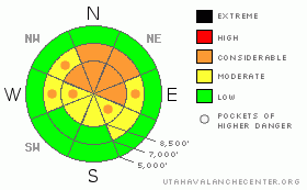
Danger Rose Tutorial
|
There is a CONSIDERABLE (level 3) avalanche danger in the backcountry, and dangerous avalanche conditions exist on many slopes above around 7500' in elevation. Human-triggered avalanches continue to be probable on slopes steeper than about 35 degrees. Avalanches could be triggered remotely from a distance or from below, so we need stay out from under avalanche paths
Careful snowpack evaluation, cautious route-finding, and conservative decision-making are essential for safe backcountry travel today. |
|
|
CURRENT CONDITIONS |

|
Dangerous avalanche conditions continue to plague upper elevation slopes in the region that did not avalanche during last weekend's storm...Most folks are playing it safe locally, and there are lots and lots of steep suspect slopes that remain untracked and untested in the region..
This morning, the Tony Grove Snotel reports an air temperature of 22 degrees, with 32 inches of total snow containing 5.5 inches of water equivalent. This gives the 8400’ weather station 53% of average snow for the date. Its 17 degrees at 9700’ on Logan Peak, and the Campbell Scientific weather station reports calm conditions under a light northerly flow…. |
|
|
RECENT ACTIVITY |

|
A widespread natural avalanche cycle occurred region-wide on Sunday 12-13-09 with large and scary natural avalanches.......One party reported remotely triggering a couple avalanches near Tony Grove Campground...(12-14-09 photos)
Yesterday again was a scary day in the Central Wasatch Range with at least 2 more large unintentionally human triggered avalanches in the backcountry…This brings the string of days with close calls with tricky and dangerous avalanches in Utah up to at least 5.....(current conditions page)
The weakness and poor structure of an unstable snowpack persist, and again yesterday we noted and observers reported widespread and extensive triggered audible collapses… Snow stability tests continue to show a widespread, scary weakness and propagation tendency. (Holiday Bowl 12-17-09) |
|
|
THREAT #1 |

|
| WHERE |
PROBABILITY |
SIZE |
TREND |
|
|
|
|
| |
|
|
Over the next
24 hours.
|
|
|
Ugly faceted snow plagues most upper and mid elevation slopes, and new slabs built by significant heavy snow this weekend caused a very unstable snow structure. This is a persistent and very dangerous problem, and a great danger of triggering dangerous avalanches remains...In these conditions avalanches can easily be triggered remotely, from a distance or worse, from below.
Avalanches have been reported on lower angle (than expected) slopes. Also, keep in mind that lower angled slopes can become involved in avalanches if they're attached to steeper ones. |
|
|
MOUNTAIN WEATHER |

|
Looks like continued benign weather with a high pressure system strengthening into the weekend....Our next chance for more snow comes early next week. Expect periods of sunshine and high temperatures near 30 degrees today in the mountains with a light west breeze....And partly cloudy conditions in the mountains with some light snow possible with smog in Cache Valley through the weekend.... |
|
|
GENERAL ANNOUNCEMENTS |
I will be issuing morning avalanche advisories for the Logan area on Mondays, Wednesdays, Fridays and Saturdays.
Discount Lift tickets: Ski Utah, Backcountry.com, Alta, Deer Valley, Park City, The Canyons, Wolf Mountain, Snowbasin, Beaver Mountain, Brighton, Sundance, and Solitude have donated a limited number of tickets for sale at discounted prices.
If you want to get this avalanche advisory e-mailed to you daily click HERE.
Send us your avalanche and snow observations. You can also call 801-524-5304 or 800-662-4140, or email to uac@utahavalanchecenter.org
Donate to your favorite non-profit – The Friends of the Utah Avalanche Center. The UAC depends on contributions from users like you to support our work.
The information in this advisory is from the U.S. Forest Service, which is solely responsible for its content. This advisory describes general avalanche conditions and local variations always occur.
I will update this forecast on Saturday morning. Thanks for checking in.... |
|
|
This information does not apply to developed ski areas or highways where avalanche control is normally done. This advisory is from the U.S.D.A. Forest Service, which is solely responsible for its content. This advisory describes general avalanche conditions and local variations always occur. |
|
This advisory provided by the USDA Forest Service, in partnership with:
The Friends of the Utah Avalanche Center, Utah Division of State Parks and Recreation, Utah Division of Emergency Management, Salt Lake County, Salt Lake Unified Fire Authority and the friends of the La Sal Avalanche Center. See our Sponsors Page for a complete list. |
