SPECIAL ANNOUNCEMENT |
 |
Just in time so that you don't have to take the big risk in sketchy avalanche conditions, Beaver Mountain is opening on Thursday 12-17-09......great job gett'n it going guys.
Once again Ski Utah, Backcountry.com, Alta, Deer Valley, Park City, The Canyons, Wolf Mountain, Snowbasin, Beaver Mountain, Brighton, Sundance, and Solitude have teamed up to give the Friends of the Utah Avalanche Center a holiday present - Lift Tickets! We have a limited number of tickets for sale at discounted prices. To order online, go to http://www.backcountry.com/store/promo/6235/hol08-uac-dki-pass-vm.html
Please go to the above site to order your discounted Beaver Mountain day tickets......
-Paige will give a free Know Before You Go avalanche awareness talk Thursday night at 6:00 at the USU Outdoor Recreation Center |
|
|
BOTTOM LINE
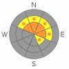
Danger by aspect and elevation on slopes approaching 35° or steeper.
(click HERE for tomorrow's danger rating)
|

Danger Rose Tutorial
|
Overall, there is a CONSIDERABLE (3) avalanche danger in the backcountry, and dangerous human-triggered avalanches are probable on slopes steeper than about 35 degrees. Avalanches could be triggered from a distance or from below....Dangerous avalanche conditions exist on steep wind drifted slopes, mainly at upper elevations.....
Careful snowpack evaluation, cautious route-finding, and conservative decision-making are essential for safe backcountry travel today. |
|
|
CURRENT CONDITIONS |

|
Mountain weather stations report a few inches of new snow overnight and temperatures in the mid twenties. The Tony Grove Snotel shows 4/10ths of an inch of water in about 3 inches of new snow. Fairly strong winds southwest winds yesterday and increasingly strong west winds this morning drifted snow into north and east facing avalanche paths, hiding evidence of the extensive recent activity and creating more danger. |
|
|
RECENT ACTIVITY |

|
A widespread natural avalanche cycle occurred region-wide on Sunday, with large and scary natural avalanches.......One party reported remotely triggering a couple avalanches near Tony Grove Campground...(12-14-09 photos)
Yesterday was a scary day in the Central Wasatch Range with at least 5 large human triggered avalanches in the backcountry…Thankfully, most of these were triggered remotely from above.
From yesterday locally; observers report extensive natural avalanche activity in the Logan Peak Area with slides to faceted snow on the base layer (or the ground) on popular slopes in Upper Providence Canyon including the Rodeo Grounds and numerous lower angled slopes off Red Pine Ridge. In the brief clearing, we noticed evidence of widespread natural avalanches in the Central Bear River Range as well, with notable avalanches apparent in Holiday Bowl in upper Blind Hollow and Rock Bowl south of Tony Grove. We noted and observers report widespread and extensive triggered audible collapses.. These were often accompanied by shooting cracks and shaking bushes up to 100 feet away….
The weakness and structure of an unstable snowpack persist and today are reloaded in exposed terrain by additional accumulation and wind drifting. |
|
|
THREAT #1 |

|
| WHERE |
PROBABILITY |
SIZE |
TREND |

|
|
|
|
| |
|
|
Over the next
24 hours.
|
|
|
Ugly faceted snow plagues most upper and mid elevation slopes, and new slabs built by significant heavy snow this weekend caused a very unstable snow structure. This is a persistent and very dangerous problem, and a great danger of triggering dangerous avalanches remains...In these conditions avalanches can easily be triggered remotely, from a distance or worse, from below.
Avalanches have been reported on lower angle (than expected) slopes. Also, keep in mind that lower angled slopes can become involved in avalanches if they're attached to steeper ones. |
|
|
THREAT #2 |

|
| WHERE |
PROBABILITY |
SIZE |
TREND |
|
|
|
|
| |
|
|
Over the next
24 hours.
|
|
|
Southwest winds picked up yesterday and continued for several hours...The wind shifted overnight from the west and has been increasing a bit this morning.... With fresh snowfall overnight and plenty of soft snow available for drifting, wind slabs are building again on the weak snowpack in lee slope areas, creating a danger of natural and triggered avalanches.... |
|
|
MOUNTAIN WEATHER |

|
A series of weak storms will push through the northern Bear River Range this afternoon through Thursday. We are likely to see some snowfall in the mountains, but not a whole lot...Overnight tonight and Wednesday appear to offer the best chance for a couple inches of accumulation.
Expect mountain high temperatures near 25 degrees today with light snow and a west wind....Expect clearing conditions later in the week. |
|
|
GENERAL ANNOUNCEMENTS |
I will be issuing morning avalanche advisories for the Logan area on Mondays, Wednesdays, Fridays and Saturdays.
Our web site is now formatted for iPhone. You can also download a free iPhone application from Canyon Sports to display the Bottom Line. Search for Utah Avalanche on the Apple's iPhone Apps page or in iTunes.
If you want to get this avalanche advisory e-mailed to you daily click HERE.
Donate to your favorite non-profit – The Friends of the Utah Avalanche Center. The UAC depends on contributions from users like you to support our work. To find out more about how you can support our efforts to continue providing the avalanche forecasting and education that you expect please visit our Friends page.
We appreciate avalanche and snow observations. If there’s something we should know about, especially if you see or trigger an avalanche in the backcountry, please give us a call at (435-)755-3638 or 1-800-662-4140, or email us at uac@utahavalanchecenter.org. (Fax 801-524-6301).
The information in this advisory is from the U.S. Forest Service, which is solely responsible for its content. This advisory describes general avalanche conditions and local variations always occur. |
|
|
This information does not apply to developed ski areas or highways where avalanche control is normally done. This advisory is from the U.S.D.A. Forest Service, which is solely responsible for its content. This advisory describes general avalanche conditions and local variations always occur. |
|
This advisory provided by the USDA Forest Service, in partnership with:
The Friends of the Utah Avalanche Center, Utah Division of State Parks and Recreation, Utah Division of Emergency Management, Salt Lake County, Salt Lake Unified Fire Authority and the friends of the La Sal Avalanche Center. See our Sponsors Page for a complete list. |
