AVALANCHE WARNING »
Dangerous avalanche conditions are occuring or are imminent.
Backcountry travel in avalanche terrain is not recommended.
|
 |
Notice: We've continued the Avalanche Warning for the mountains of Northern and Central Utah...New snow accumulations have overloaded preexisting weak snow causing both natural and human triggered avalanches. There is a HIGH avalanche danger in the backcountry. People without expert level snowpack assessment and backcountry travel skills are urged to stay out of the mountains. |
|
|
BOTTOM LINE
Danger by aspect and elevation on slopes approaching 35° or steeper.
(click HERE for tomorrow's danger rating)
|
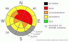
Danger Rose Tutorial
|
There is a HIGH (4) avalanche danger at upper and mid-elevations in the backcountry, and dangerous human triggered avalanches are likely. Avalanches could be triggered from a distance or from below....We must continue to avoid and stay out from under steep slopes and obvious or historic avalanche paths today.... |
|
|
CURRENT CONDITIONS |

|
Local 8000 foot Snotel sites report more than 2 inches of water equivalent snowfall from over the weekend. The Tony Grove site reports around 20 inches of accumulation on the total snow stake, (which is including settlement of both the old and new snow.)
You should avoid travel in avalanche terrain today....Upper and mid-elevation elevation northerly facing slopes that had a fair amount of preexisting snow are the most dangerous and will likely produce significant and dangerous avalanches.. Definitely not a good day for hill-climbing with a HIGH avalanche danger on any upper and mid-elevation hills with enough snow-cover to ride up…….Remember to slow down and watch out for pedestrians, especially in congested areas like Tony Grove. |
|
|
RECENT ACTIVITY |

|
Countless natural and human triggered avalanches reported in the Central Wasatch Range yesterday. In the Wasatch backcountry from over the weekend come a few survival stories, with at least 5 people caught in avalanches and carried, 4 partially buried, and 1 person fully buried but rescued OK.....
Although few got out into the Logan Area backcountry yesterday, I got reports of knee to thigh deep new snow in the Tony Grove area. One observer reported, "There was collapsing on flat and low angle slopes while we walked up. Shooting cracks. The snow had that very hollow feel while taking runs. Very unstable."
In fact, Logan Area observers reported collapsing, cracking, wind loading, rapidly accumulating snow, rapid warming, and avalanche activity over the weekend... These are all signs of unstable snow...It'll be interesting to try and determine the extent of a natural cycle in our area, which likely occurred late yesterday. Any reports of avalanche activity in the backcountry will be most appreciated as I try to size up the details...
Some natural avalanches may occur and human triggered avalanches are likely today as deep heavy snow accumulated on slopes with very weak preexisting snow. |
|
|
THREAT #1 |

|
| WHERE |
PROBABILITY |
SIZE |
TREND |

|
|
|
|
| |
|
|
Over the next
24 hours.
|
|
|
Ugly faceted snow plagues most upper and mid elevation slopes, and new slabs built by significant heavy snow this weekend caused an unstable snow structure and a drastic increase in avalanche danger….........
Although natural activity should be tapering off today, a great danger of triggering dangerous avalanches remains...In these conditions avalanches can easily be triggered remotely, from a distance or from below. Also lower angled slopes can become involved in avalanches if attached to steeper ones that rip out.... |
|
|
THREAT #2 |

|
| WHERE |
PROBABILITY |
SIZE |
TREND |

|
|
|
|
| |
|
|
Over the next
24 hours.
|
|
|
In many areas tons of fresh heavy snow piled up on slopes with little or no snow cover. Triggered wind slab and storm snow avalanches are possible on steep slopes facing all directions....These may fail on density changes within the new snow, on colder snow from Friday night, or on a thin layer of faceted old snow on the ground.... |
|
|
MOUNTAIN WEATHER |

|
Snow showers will continue through much of the day, with another couple inches of accumulating snowfall likely in the Bear River Range....Expect high mountain temperatures around 20 degrees with moderate southwest winds. Should see a brief break in the weather this afternoon and tonight as a short-lived ridge of high pressure builds in...This won't last long in the Bear River Range, as a moist westerly flow will resume tomorrow continuing the on and off pattern of showery snowfall, especially at upper elevations.... |
|
|
GENERAL ANNOUNCEMENTS |
I will be issuing morning avalanche advisories for the Logan area on Mondays, Wednesdays, Fridays and Saturdays.
Our web site is now formatted for iPhone. You can also download a free iPhone application from Canyon Sports to display the Bottom Line. Search for Utah Avalanche on the Apple's iPhone Apps page or in iTunes.
If you want to get this avalanche advisory e-mailed to you daily click HERE.
Donate to your favorite non-profit – The Friends of the Utah Avalanche Center. The UAC depends on contributions from users like you to support our work. To find out more about how you can support our efforts to continue providing the avalanche forecasting and education that you expect please visit our Friends page.
We appreciate avalanche and snow observations. If there’s something we should know about, especially if you see or trigger an avalanche in the backcountry, please give us a call at (435-)755-3638 or 1-800-662-4140, or email us at uac@utahavalanchecenter.org. (Fax 801-524-6301).
The information in this advisory is from the U.S. Forest Service, which is solely responsible for its content. This advisory describes general avalanche conditions and local variations always occur. |
|
|
This information does not apply to developed ski areas or highways where avalanche control is normally done. This advisory is from the U.S.D.A. Forest Service, which is solely responsible for its content. This advisory describes general avalanche conditions and local variations always occur. |
|
This advisory provided by the USDA Forest Service, in partnership with:
The Friends of the Utah Avalanche Center, Utah Division of State Parks and Recreation, Utah Division of Emergency Management, Salt Lake County, Salt Lake Unified Fire Authority and the friends of the La Sal Avalanche Center. See our Sponsors Page for a complete list. |
