AVALANCHE WATCH »
The risk of an avalanche is expected to increase significantly
but the timing and location are still uncertain. Stay tuned for updates.
|
 |
Notice: We've issued an Avalanche Watch......Heavy snowfall and strong winds are expected to create dangerous avalanche conditions Saturday night and Sunday. |
|
|
BOTTOM LINE
Danger by aspect and elevation on slopes approaching 35° or steeper.
(click HERE for tomorrow's danger rating)
|
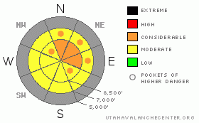
Danger Rose Tutorial
|
This morning, there is a MODERATE (level 2) avalanche danger in the backcountry, and you could trigger wind slab avalanches on drifted slopes steeper than about 35 degrees.
With significant snowfall, winds, and warmer temperatures in the forecast, we expect the danger to rise significantly and become more widespread over the weekend in the backcountry. The avalanche danger is likely to rise to CONSIDERABLE (level 3) overnight. As the storm intensifies tomorrow, the danger could rise further, and a sizable natural avalanche cycle may occur at upper elevations…. |
|
|
CURRENT CONDITIONS |

|
Expect heightened avalanche conditions and an increasing danger as a potent and moist storm system drives into the region... The snow-covered road to Tony Grove Lake is not maintained in the winter, and this weekend's storm is very likely to shut it down to wheeled vehicles at least up high... Be prepared for full-on winter conditions and incoming stormy weather as driving conditions may deteriorate rapidly....
The very shallow snowcover in most areas just isn’t enough to keep you from hitting damaging and dangerous rocks hidden just under the snow surface. Remember to slow down and watch out for pedestrians, especially in congested areas like Tony Grove. |
|
|
RECENT ACTIVITY |

|
No activity has been reported in the Logan Area since last weekend, when there were a couple small avalanches triggered in the south Tony Grove Lake area....There were also a number of triggered avalanches in the Central Wasatch Range, mainly in the early part of the week...
We cracked several wind drifts and small wind slabs in terrain features yesterday and noted localized collapsing on exposed upper elevation terrain accessible from Tony Grove…These are bad signs... |
|
|
THREAT #1 |

|
| WHERE |
PROBABILITY |
SIZE |
TREND |
|
|
|
|
| |
|
|
Over the next
24 hours.
|
|
|
Winds in the last few days and again last night built wind slabs with the light density new snow. You might trigger soft slabs or hard slabs around a foot deep on steep slopes. I'd be especially cautious on exposed slopes and around terrain features where cross-loading has drifted-in significant snow. The danger of fresh wind slab and storm snow avalanches will rise with snow accumulation this weekend. |
|
|
THREAT #2 |

|
| WHERE |
PROBABILITY |
SIZE |
TREND |
|
|
|
|
| |
|
|
Over the next
24
hours.
|
|
|
Some of last week’s wind slabs formed on a persistent weak layer made up of sugary faceted old snow....Ugly facets plague most slopes, and slabs built by significant heavy snow forecast for the weekend will cause an unstable snow structure and a drastic increase in avalanche danger….. |
|
|
MOUNTAIN WEATHER |

|
The National Weather Service has issued a Winter Storm Warning for our region.....Expect increasing snowfall becoming heavy overnight, continued and increasing southwest winds through tonight......
The next stronger round, later on Sunday has the potential to be the knockout blow, with significant total accumulations likely in the mountains and the valleys .......... |
|
|
GENERAL ANNOUNCEMENTS |
I will be issuing morning avalanche advisories for the Logan area on Mondays, Wednesdays, Fridays and Saturdays.
Our web site is now formatted for iPhone. You can also download a free iPhone application from Canyon Sports to display the Bottom Line. Search for Utah Avalanche on the Apple's iPhone Apps page or in iTunes.
If you want to get this avalanche advisory e-mailed to you daily click HERE.
Donate to your favorite non-profit – The Friends of the Utah Avalanche Center. The UAC depends on contributions from users like you to support our work. To find out more about how you can support our efforts to continue providing the avalanche forecasting and education that you expect please visit our Friends page.
We appreciate avalanche and snow observations. If there’s something we should know about, especially if you see or trigger an avalanche in the backcountry, please give us a call at (435-)755-3638 or 1-800-662-4140, or email us at uac@utahavalanchecenter.org. (Fax 801-524-6301).
The information in this advisory is from the U.S. Forest Service, which is solely responsible for its content. This advisory describes general avalanche conditions and local variations always occur. |
|
|
This information does not apply to developed ski areas or highways where avalanche control is normally done. This advisory is from the U.S.D.A. Forest Service, which is solely responsible for its content. This advisory describes general avalanche conditions and local variations always occur. |
|
This advisory provided by the USDA Forest Service, in partnership with:
The Friends of the Utah Avalanche Center, Utah Division of State Parks and Recreation, Utah Division of Emergency Management, Salt Lake County, Salt Lake Unified Fire Authority and the friends of the La Sal Avalanche Center. See our Sponsors Page for a complete list. |
