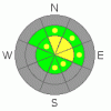
BOTTOM LINE
Danger by aspect and elevation on slopes approaching 35° or steeper.
(click HERE for tomorrow's danger rating)
|

Danger Rose Tutorial
|
There is a MODERATE danger on steep drifted slopes in the backcountry. You could trigger wind slab avalanches on exposed upper elevation slopes steeper than about 35 degrees. Dry loose avalanches are also probable on very steep slopes… |
|
|
CURRENT CONDITIONS |

|
Super cold northerly winds kept us off the exposed ridge-lines yesterday, but we found some nice shallow powder and mostly avoided rocks in the Tony Grove Area. Gradual accumulations over the last few days stacked several inches of new snow on upper elevation slopes. But it's still quite boney, and you should try to keep your speed down since hitting rocks or other shallowly buried obstacles still presents the greatest risk in most areas.
Shallow, early season conditions persist and riders still pretty much have to stay on snow covered upper elevation roadways. Remember to slow down and watch out for pedestrians, especially in congested areas like Tony Grove. |
|
|
RECENT ACTIVITY |

|
Sunday's meager snow with some wind brought about a couple small triggered soft slabs on very steep slopes south of Tony Grove Lake. One snowboarder told of being caught and carried for a short distance. Yesterday, we avoided steep drifted slopes but caused a couple good-sized loose sluffs that entrained old sugary snow…. It was an active day in the Central and Southern Wasatch zones yesterday, with several sizable triggered avalanches in the backcountry…
(go to our current conditions page, Here; for more details.) |
|
|
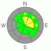
THREAT #1 |

|
| WHERE |
PROBABILITY |
SIZE |
TREND |
|
|
|
|
| |
|
|
Over the next
24 hours.
|
|
|
Winds in the last few days built wind slabs with the light density new snow. These slabs in many cases have formed right on top of weak faceted snow or feathery surface hoar, and you might trigger soft slabs around a foot deep on steep upper elevation slopes. I'd be especially cautious on exposed slopes and around terrain features where cross-loading has drifted-in significant snow. |
|
|
THREAT #2 |

|
| WHERE |
PROBABILITY |
SIZE |
TREND |
|
|
|
|
| |
|
|
Over the next
24
hours.
|
|
|
Loose, point-release avalanches on steep slopes are gouging down into old faceted or weak sugary snow and entraining a bit more snow than expected. |
|
|
MOUNTAIN WEATHER |

|
It'll be very cold through the end of the week, with high forecast temperatures below zero in the mountains today and a chilling northwest breeze....Looks like a moist and warmer pattern will develop over the weekend, with accumulating snowfall quite likely, but the timing in doubt….
|
|
|
GENERAL ANNOUNCEMENTS |
I will be issuing morning avalanche advisories for the Logan area on Mondays, Wednesdays, Fridays and Saturdays.
Our web site is now formatted for iPhone. You can also download a free iPhone application from Canyon Sports to display the Bottom Line. Search for Utah Avalanche on the Apple's iPhone Apps page or in iTunes.
If you want to get this avalanche advisory e-mailed to you daily click HERE.
Donate to your favorite non-profit – The Friends of the Utah Avalanche Center. The UAC depends on contributions from users like you to support our work. To find out more about how you can support our efforts to continue providing the avalanche forecasting and education that you expect please visit our Friends page.
We appreciate avalanche and snow observations. If there’s something we should know about, especially if you see or trigger an avalanche in the backcountry, please give us a call at (435-)755-3638 or 1-800-662-4140, or email us at uac@utahavalanchecenter.org. (Fax 801-524-6301).
The information in this advisory is from the U.S. Forest Service, which is solely responsible for its content. This advisory describes general avalanche conditions and local variations always occur. |
|
|
This information does not apply to developed ski areas or highways where avalanche control is normally done. This advisory is from the U.S.D.A. Forest Service, which is solely responsible for its content. This advisory describes general avalanche conditions and local variations always occur. |
|
This advisory provided by the USDA Forest Service, in partnership with:
The Friends of the Utah Avalanche Center, Utah Division of State Parks and Recreation, Utah Division of Emergency Management, Salt Lake County, Salt Lake Unified Fire Authority and the friends of the La Sal Avalanche Center. See our Sponsors Page for a complete list. |
