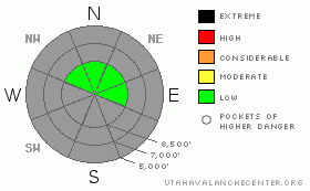
BOTTOM LINE
Danger by aspect and elevation on slopes approaching 35° or steeper.
(click HERE for tomorrow's danger rating)
|
Danger Rose Tutorial
|
There is currently a LOW avalanche danger in the backcountry. The danger will begin to rise with any accumulating snowfall this weekend, and I expect heightened avalanche conditions with continued stormy weather early next week. |
|
|
CURRENT CONDITIONS |

|
At least lack of snow is keeping forest visitor numbers down, and you can definitely find solitude in the backcountry these days. You'll also find a wide variety of wind sculpted and tracked old snow surfaces, especially on the popular smooth north facing slopes south of Tony Grove Lake. Snow cover is limited to north facing upper elevation slopes, and hitting rocks or other shallowly buried obstacles probably still presents the largest safety concern....
There's just not enough snow for backcountry riding, and you pretty much have to stay on snow covered upper elevation roadways. Remember to slow down and watch out for pedestrians, especially in congested areas like Tony Grove.
|
|
|
RECENT ACTIVITY |

|
Just before Thanksgiving, I triggered a fairly large wind slab avalanche from the ridge in the West Tony Grove Area. We'll have to worry about similar activity when inevitable snowfall and wind build a slab on top of the widespread weak and sugary snow now covering upper elevation shady slopes.
click :avalanche report |
|
|
THREAT #1 |

|
| WHERE |
PROBABILITY |
SIZE |
TREND |

|
|
|
|
| |
|
|
Over the next
24
hours.
|
|
|
Although I know I’m in Northern Utah, backcountry snow conditions make the Bear River Range high country seem a lot more like the Colorado Rockies… Untracked shallow snow on the ground is now quite weak and quickly getting weaker. Recent cold temperatures and dry air intensified water vapor sublimation rapidly re-crystallizing the shallow snowpack. Like in Colorado, slopes currently boasting any snow-cover will be plagued by dangerous and deceitful faceted basal layers when an inevitable slab forms on them. With incoming snowy weather, I expect avalanche conditions in the backcountry to become increasingly dangerous next week....
Today, there are isolated upper elevation pockets where you might trigger stiff wind slab avalanches on very steep slopes in exposed terrain. |
|
|
MOUNTAIN WEATHER |

|
Finally, the weather pattern is changing. The first wave of storminess will come in the form of a cold front dropping south out of Western Canada, affecting our area late tonight or early Saturday with modest to light snowfall. Another wave of wet Pacific weather will impact mainly Southern Utah on Sunday. Expect a developing pattern of storms and continued moist and unsettled weather throughout the upcoming week with warmer temperatures and a good chance for significant snow accumulations in the mountains. |
|
|
GENERAL ANNOUNCEMENTS |
We will be issuing intermittent avalanche advisories as conditions warrant. I'll begin to issue regular advisories later in December and when the winter season really gets rolling....
Our web site is now formatted for iPhone. You can also download a free iPhone application from Canyon Sports to display the Bottom Line. Search for Utah Avalanche on the Apple's iPhone Apps page or in iTunes.
If you want to get this avalanche advisory e-mailed to you daily click HERE.
Donate to your favorite non-profit – The Friends of the Utah Avalanche Center. The UAC depends on contributions from users like you to support our work. To find out more about how you can support our efforts to continue providing the avalanche forecasting and education that you expect please visit our Friends page.
We appreciate avalanche and snow observations. If there’s something we should know about give us a call at (435-)755-3638 or 1-800-662-4140, or email us at uac@utahavalanchecenter.org. (Fax 801-524-6301).
The information in this advisory is from the U.S. Forest Service, which is solely responsible for its content. This advisory describes general avalanche conditions and local variations always occur. |
|
|
This information does not apply to developed ski areas or highways where avalanche control is normally done. This advisory is from the U.S.D.A. Forest Service, which is solely responsible for its content. This advisory describes general avalanche conditions and local variations always occur. |
|
This advisory provided by the USDA Forest Service, in partnership with:
The Friends of the Utah Avalanche Center, Utah Division of State Parks and Recreation, Utah Division of Emergency Management, Salt Lake County, Salt Lake Unified Fire Authority and the friends of the La Sal Avalanche Center. See our Sponsors Page for a complete list. |
