SPECIAL ANNOUNCEMENT |
 |
Hope to see you at the 6th annual "Pray for Snow" FUAC fundraiser dinner on Wednesday, December 2nd at 6:30 at the Italian Place on Federal Ave. |
|
|
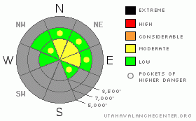
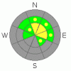
BOTTOM LINE
Danger by aspect and elevation on slopes approaching 35° or steeper.
(click HERE for tomorrow's danger rating)
|
Danger Rose Tutorial
|
Strong south and west winds along with snowfall over the weekend heightened avalanche conditions in the backcountry. There is a MODERATE danger of persistent wind slab avalanches on steep drifted upper elevation slopes. Sizable triggered slab avalanches are possible above 8500' on slopes steeper than about 35 degrees with preexisting snow. |
|
|
CURRENT CONDITIONS |

|
Snow cover before the weekend's snowfall was limited to north facing upper elevation slopes, and hitting rocks or other shallowly buried obstacles probably still presents the largest safety concern....The Tony Grove Snotel reports about 6 inches of new snow from Sunday, and it was very windy all weekend, with significant wind-drifting observed in exposed terrain.
Riding is still pretty much confined to upper elevation roadways, and you have to slow down and watch out for pedestrians, especially in congested areas like Tony Grove. |
|
|
RECENT ACTIVITY |

|
Yesterday, I triggered a fairly large avalanche from the ridge in the West Tony Grove Area. I stamped my ski on the drifted snow along the low angled ridge line when the slab pealed out along the ridge in front and washed into the bowl below. The avalanche, triggered at 9400' on a north northeast facing slope was 1 to 2 feet deep, around 300' wide, and ran around 600' vertical. It was a a bit larger and the slope a bit more sensitive than I'd expected, and it caused us to reevaluate our plan and return to safer, lower elevation sheltered terrain.
click:avalanche report |
|
|
THREAT #1 |

|
| WHERE |
PROBABILITY |
SIZE |
TREND |
|
|
|
|
| |
|
|
Over the next
24
hours.
|
|
|
Strong south and west winds over the weekend and yesterday built stiff slabs right on top of weak sugary faceted snow from last week's clear weather. Today, you might trigger persistent wind slab avalanches in the 1 to 2 foot deep category on steep drifted slopes with preexisting snow in exposed terrain. |
|
|
THREAT #2 |

|
| WHERE |
PROBABILITY |
SIZE |
TREND |
|
| No probability identified. |
|
|
|
|
|
Probably rocks will still be the biggest threat out there, but now you should certainly begin to follow proper traveling protocols and carry and practice with your avalanche rescue gear...
Remember; try to get into the habit of, when ever possible, only exposing one member of your party to avalanche risk at a time. This really means spread out farther when traveling on or under steep terrain... |
|
|
MOUNTAIN WEATHER |

|
A high pressure system will strengthen over the region in the next couple days, and we'll see fair weather in the mountains and haze trapped in the Valley. Hopefully winds will mix up the air on Thanksgiving Day, and it looks like our next storm is on track for the holiday weekend. |
|
|
GENERAL ANNOUNCEMENTS |
We will be issuing intermittent avalanche advisories as conditions warrant. I'll begin to issue regular advisories in December when the winter season gets rolling....
Our web site is now formatted for iPhone. You can also download a free iPhone application from Canyon Sports to display the Bottom Line. Search for Utah Avalanche on the Apple's iPhone Apps page or in iTunes.
If you want to get this avalanche advisory e-mailed to you daily click HERE.
Donate to your favorite non-profit – The Friends of the Utah Avalanche Center. The UAC depends on contributions from users like you to support our work. To find out more about how you can support our efforts to continue providing the avalanche forecasting and education that you expect please visit our Friends page.
We appreciate avalanche and snow observations. If there’s something we should know about give us a call at (435-)755-3638 or 1-800-662-4140, or email us at uac@utahavalanchecenter.org. (Fax 801-524-6301).
The information in this advisory is from the U.S. Forest Service, which is solely responsible for its content. This advisory describes general avalanche conditions and local variations always occur. |
|
|
This information does not apply to developed ski areas or highways where avalanche control is normally done. This advisory is from the U.S.D.A. Forest Service, which is solely responsible for its content. This advisory describes general avalanche conditions and local variations always occur. |
|
This advisory provided by the USDA Forest Service, in partnership with:
The Friends of the Utah Avalanche Center, Utah Division of State Parks and Recreation, Utah Division of Emergency Management, Salt Lake County, Salt Lake Unified Fire Authority and the friends of the La Sal Avalanche Center. See our Sponsors Page for a complete list. |
